Property Record
15180 S Dixie Hwy, Monroe, MI 48161
NEARBY LISTINGS FOR SALE OR LEASE
Property Detail
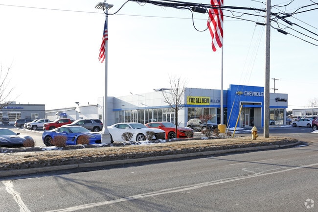
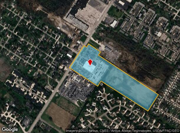
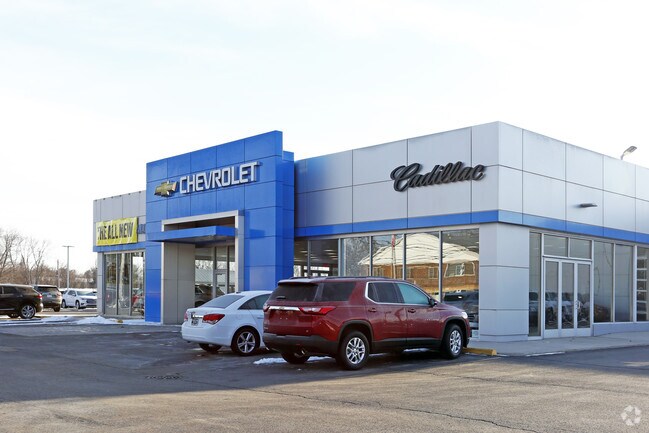
15180 S Dixie Hwy
12-010-316-01
Private Claims 230 & 498
Vehiclerentalsvehiclesales
MAPS 42 & 44 PC 230 & 498 18.61 AMOL COM AT THE NW COR OF SD PC 230 TH ALG THE NW'LY LI OF SD PC 230 S 34?15'00" W 10664.49
X
Monroe
26115C0243F
Michigan
2025
18.60 AC
2025
Monroe County
832500
Detroit
40,476 SF
Monroe, MI
DEMOGRAPHICS near 15180 S Dixie Hwy
1 Mile
3 Mile
5 Mile
2024 Total Population
5,531
33,477
49,746
2029 Population
5,580
33,991
50,509
Pop Growth 2024-2029
+ 0.89%
+ 1.54%
+ 1.53%
Average Age
44
41
42
2024 Total Households
2,411
13,635
20,397
HH Growth 2024-2029
+ 0.87%
+ 1.46%
+ 1.46%
Median Household Inc
$63,699
$57,043
$59,308
Avg Household Size
2.20
2.30
2.30
2024 Avg HH Vehicles
2.00
2.00
2.00
Median Home Value
$199,999
$155,702
$169,837
Median Year Built
1975
1963
1968
Nearby Places
Map Layers
Map Styles
 Street
 Aerial
- Restaurants
- Banks
- Shops
- Fitness
- Groceries
PUBLIC TRANSPORTATION
AIRPORT
Detroit Metro Wayne County
DRIVE
WALK
Distance
Detroit Metro Wayne County
40 min
26.6 mi
Eugene F Kranz Toledo Express
DRIVE
WALK
Distance
Eugene F Kranz Toledo Express
59 min
38.2 mi
Freight Ports
DRIVE
WALK
Distance
35 min
22.4 mi
Nearby Properties
Address
Land Use
TOTAL SIZE
Lot Size
Zoning
Address
Land Use
TOTAL SIZE
Lot Size
Zoning
97.18 AC
Address
Land Use
TOTAL SIZE
Lot Size
Zoning
Address
Land Use
TOTAL SIZE
Lot Size
Zoning
109,073 SF
47.32 AC
Address
Land Use
TOTAL SIZE
Lot Size
Zoning
183,508 SF
70 AC
Address
Land Use
TOTAL SIZE
Lot Size
Zoning
13.60 AC
Address
Land Use
TOTAL SIZE
Lot Size
Zoning
108,575 SF
38.21 AC
R-1A
Address
Land Use
TOTAL SIZE
Lot Size
Zoning
43,528 SF
16.06 AC
MHP
Address
Land Use
TOTAL SIZE
Lot Size
Zoning
317,482 SF
20.53 AC
Address
Land Use
TOTAL SIZE
Lot Size
Zoning
2,195 SF
86.71 AC
MHP
Address
Land Use
TOTAL SIZE
Lot Size
Zoning
41 AC
MHP
Address
Land Use
TOTAL SIZE
Lot Size
Zoning
149,282 SF
7.57 AC
R-1A
Address
Land Use
TOTAL SIZE
Lot Size
Zoning
13.38 AC
Address
Land Use
TOTAL SIZE
Lot Size
Zoning
6.78 AC
Address
Land Use
TOTAL SIZE
Lot Size
Zoning
975 SF
34.50 AC
MHP
Address
Land Use
TOTAL SIZE
Lot Size
Zoning
150,200 SF
5.68 AC
R-1A
Address
Land Use
TOTAL SIZE
Lot Size
Zoning
106,200 SF
10.83 AC
R-1A
Address
Land Use
TOTAL SIZE
Lot Size
Zoning
37,210 SF
0.57 AC
R-1A
Address
Land Use
TOTAL SIZE
Lot Size
Zoning
16.65 AC
Address
Land Use
TOTAL SIZE
Lot Size
Zoning
104,117 SF
12.04 AC
Address
Land Use
TOTAL SIZE
Lot Size
Zoning
88,131 SF
10.18 AC
R-1A
Address
Land Use
TOTAL SIZE
Lot Size
Zoning
38,011 SF
4.02 AC
R-1A
Address
Land Use
TOTAL SIZE
Lot Size
Zoning
57,022 SF
4 AC
R-1A
Address
Land Use
TOTAL SIZE
Lot Size
Zoning
29,100 SF
2.74 AC
Address
Land Use
TOTAL SIZE
Lot Size
Zoning
26,864 SF
7.57 AC
Address
Land Use
TOTAL SIZE
Lot Size
Zoning
18,894 SF
2.19 AC
R-1A
Address
Land Use
TOTAL SIZE
Lot Size
Zoning
66,912 SF
4.90 AC
Address
Land Use
TOTAL SIZE
Lot Size
Zoning
29.94 AC
Address
Land Use
TOTAL SIZE
Lot Size
Zoning
11,420 SF
200.20 AC
Address
Land Use
TOTAL SIZE
Lot Size
Zoning
55,923 SF
3.12 AC
R-1A
The World's #1 Commercial Real Estate Marketplace
Connect with us
© 2025 CoStar Group
The information above has been obtained from sources believed reliable. While we do not doubt its accuracy we have not verified it and make no guarantee, warranty or representation about it. It is your responsibility to independently confirm its accuracy and completeness. Any projections, opinions, assumptions, or estimates used are for example only and do not represent the current or future performance of the property. The value of this transaction to you depends on tax and other factors which should be evaluated by your tax, financial, and legal advisors. You and your advisors should conduct a careful, independent investigation of the property to determine to your satisfaction the suitability of the property for your needs.