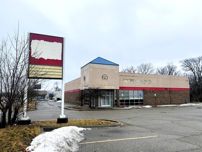
Property Record
15181 Telegraph Rd, Redford, MI 48239


Current Lease Availabilities
NEARBY LISTINGS FOR SALE OR LEASE
Property Detail
15181 Telegraph Rd
Detroit-Warren-Dearborn, MI
Twelfth St
79-025-01-0043-300
20A 43B TO 47 TH N 1/2 OF LOT 43 ALSO LOTS 44 TO 47 INCL TELEGRAPH TWELFTH ST SUB T1S R10E L53 P2 WCR
Storebuilding
Wayne
X
Michigan
26163C0069E
43-47
2025
0.53 AC
2025
Southern I-275 Corridor
554800
Detroit
11,163 SF
DEMOGRAPHICS near 15181 Telegraph Rd
1 Mile
3 Mile
5 Mile
2024 Total Population
10,232
112,042
318,664
2029 Population
9,963
108,649
310,658
Pop Growth 2024-2029
(2.63%)
(3.03%)
(2.51%)
Average Age
39
39
39
2024 Total Households
4,420
44,988
125,349
HH Growth 2024-2029
(2.81%)
(3.15%)
(2.61%)
Median Household Inc
$40,395
$50,586
$50,485
Avg Household Size
2.30
2.40
2.50
2024 Avg HH Vehicles
1.00
2.00
2.00
Median Home Value
$95,186
$121,813
$132,069
Median Year Built
1954
1953
1954
Nearby Places
Map Layers
Map Styles
 Street
 Aerial
- Restaurants
- Banks
- Shops
- Fitness
- Groceries
PUBLIC TRANSPORTATION
AIRPORT
Detroit Metro Wayne County
DRIVE
WALK
Distance
Detroit Metro Wayne County
32 min
17.4 mi
Windsor International
DRIVE
WALK
Distance
Windsor International
41 min
25.1 mi
Nearby Properties
Address
Land Use
TOTAL SIZE
Lot Size
Zoning
Address
Land Use
TOTAL SIZE
Lot Size
Zoning
1,071,675 SF
59.61 AC
M-2
Address
Land Use
TOTAL SIZE
Lot Size
Zoning
335,133 SF
22.08 AC
Address
Land Use
TOTAL SIZE
Lot Size
Zoning
909,159 SF
55.33 AC
M-2
Address
Land Use
TOTAL SIZE
Lot Size
Zoning
1,156,275 SF
75.88 AC
M-2
Address
Land Use
TOTAL SIZE
Lot Size
Zoning
85.45 AC
Address
Land Use
TOTAL SIZE
Lot Size
Zoning
261,917 SF
9.31 AC
PD
Address
Land Use
TOTAL SIZE
Lot Size
Zoning
399,770 SF
34.90 AC
M-2
Address
Land Use
TOTAL SIZE
Lot Size
Zoning
202,736 SF
20 AC
PD
Address
Land Use
TOTAL SIZE
Lot Size
Zoning
143,700 SF
3.27 AC
PD
Address
Land Use
TOTAL SIZE
Lot Size
Zoning
835,383 SF
36.85 AC
Address
Land Use
TOTAL SIZE
Lot Size
Zoning
300,936 SF
18.40 AC
M4
Address
Land Use
TOTAL SIZE
Lot Size
Zoning
158,354 SF
43.70 AC
M4
Address
Land Use
TOTAL SIZE
Lot Size
Zoning
216,268 SF
23.58 AC
C-2
Address
Land Use
TOTAL SIZE
Lot Size
Zoning
143,941 SF
11.66 AC
PD
Address
Land Use
TOTAL SIZE
Lot Size
Zoning
167,562 SF
9.25 AC
R5
Address
Land Use
TOTAL SIZE
Lot Size
Zoning
286,524 SF
16.58 AC
Address
Land Use
TOTAL SIZE
Lot Size
Zoning
129,975 SF
6.89 AC
R5
Address
Land Use
TOTAL SIZE
Lot Size
Zoning
57,739 SF
1.71 AC
Address
Land Use
TOTAL SIZE
Lot Size
Zoning
104,567 SF
2.14 AC
PD
Address
Land Use
TOTAL SIZE
Lot Size
Zoning
141,206 SF
14.01 AC
M-1
Address
Land Use
TOTAL SIZE
Lot Size
Zoning
186.50 AC
IND
Address
Land Use
TOTAL SIZE
Lot Size
Zoning
9.07 AC
R-7
Address
Land Use
TOTAL SIZE
Lot Size
Zoning
160,300 SF
11.15 AC
M-2
Address
Land Use
TOTAL SIZE
Lot Size
Zoning
53,157 SF
2.86 AC
C-1
Address
Land Use
TOTAL SIZE
Lot Size
Zoning
97,114 SF
2.10 AC
R1
Address
Land Use
TOTAL SIZE
Lot Size
Zoning
207,088 SF
14.25 AC
R-1
Address
Land Use
TOTAL SIZE
Lot Size
Zoning
79,340 SF
3.20 AC
PD
Address
Land Use
TOTAL SIZE
Lot Size
Zoning
76,117 SF
5.57 AC
R-9
Address
Land Use
TOTAL SIZE
Lot Size
Zoning
76,117 SF
5.50 AC
R-9
Address
Land Use
TOTAL SIZE
Lot Size
Zoning
65,576 SF
7.84 AC
B3
The World's #1 Commercial Real Estate Marketplace
Connect with us
© 2025 CoStar Group
The information above has been obtained from sources believed reliable. While we do not doubt its accuracy we have not verified it and make no guarantee, warranty or representation about it. It is your responsibility to independently confirm its accuracy and completeness. Any projections, opinions, assumptions, or estimates used are for example only and do not represent the current or future performance of the property. The value of this transaction to you depends on tax and other factors which should be evaluated by your tax, financial, and legal advisors. You and your advisors should conduct a careful, independent investigation of the property to determine to your satisfaction the suitability of the property for your needs.