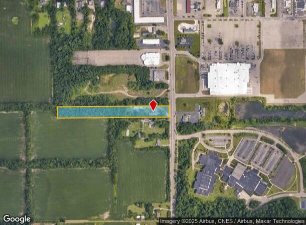
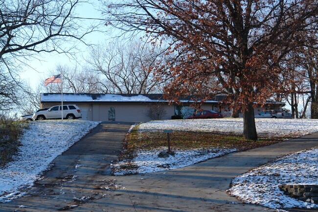
Property Record
15189 Helmer Rd S, Battle Creek, MI 49015

NEARBY LISTINGS FOR SALE OR LEASE
Property Detail
15189 Helmer Rd S
0066-00-630-0
SEC 16 T2S R8W N 132 FT OF SE 1/4 OF SE 1/4 OF SEC 16, CONT 4 AC, SUBJ TO HWY EASE OVER E 33 FT THEREOF
Officebuilding
Calhoun
X
Michigan
26025C0186C
4.03 AC
0
Battle Crk/W Calhoun Cnty
2025
West Michigan
001500
Battle Creek, MI
4,836 SF
DEMOGRAPHICS near 15189 Helmer Rd S
1 Mile
3 Mile
5 Mile
2024 Total Population
3,459
28,512
66,635
2029 Population
3,392
28,186
66,028
Pop Growth 2024-2029
(1.94%)
(1.14%)
(0.91%)
Average Age
40
39
39
2024 Total Households
1,298
11,304
27,126
HH Growth 2024-2029
(1.93%)
(1.19%)
(0.93%)
Median Household Inc
$96,690
$57,235
$47,654
Avg Household Size
2.50
2.40
2.30
2024 Avg HH Vehicles
2.00
2.00
2.00
Median Home Value
$169,238
$135,431
$113,535
Median Year Built
1958
1957
1957
Nearby Places
Map Layers
Map Styles
 Street
 Aerial
- Restaurants
- Banks
- Shops
- Fitness
- Groceries
PUBLIC TRANSPORTATION
AIRPORT
Kalamazoo/Battle Creek International
DRIVE
WALK
Distance
Kalamazoo/Battle Creek International
30 min
20.0 mi
Nearby Properties
Address
Land Use
TOTAL SIZE
Lot Size
Zoning
Address
Land Use
TOTAL SIZE
Lot Size
Zoning
158,242 SF
28.01 AC
B1
Address
Land Use
TOTAL SIZE
Lot Size
Zoning
183,198 SF
17.72 AC
RM-1
Address
Land Use
TOTAL SIZE
Lot Size
Zoning
123,060 SF
10.53 AC
I2
Address
Land Use
TOTAL SIZE
Lot Size
Zoning
131,048 SF
12.28 AC
R1A
Address
Land Use
TOTAL SIZE
Lot Size
Zoning
415,320 SF
50.04 AC
I2
Address
Land Use
TOTAL SIZE
Lot Size
Zoning
111,002 SF
AG
Address
Land Use
TOTAL SIZE
Lot Size
Zoning
158,242 SF
25.25 AC
B1
Address
Land Use
TOTAL SIZE
Lot Size
Zoning
134,355 SF
5.35 AC
MFR
Address
Land Use
TOTAL SIZE
Lot Size
Zoning
308,395 SF
24.34 AC
I2
Address
Land Use
TOTAL SIZE
Lot Size
Zoning
106,703 SF
9.69 AC
MFR
Address
Land Use
TOTAL SIZE
Lot Size
Zoning
94,222 SF
I2
Address
Land Use
TOTAL SIZE
Lot Size
Zoning
188,388 SF
18.15 AC
T3
Address
Land Use
TOTAL SIZE
Lot Size
Zoning
111,744 SF
9.75 AC
RM-1
Address
Land Use
TOTAL SIZE
Lot Size
Zoning
95,666 SF
46.56 AC
I1
Address
Land Use
TOTAL SIZE
Lot Size
Zoning
123,918 SF
24.50 AC
I2
Address
Land Use
TOTAL SIZE
Lot Size
Zoning
123,544 SF
17.11 AC
I2
Address
Land Use
TOTAL SIZE
Lot Size
Zoning
41,310 SF
3.53 AC
B2
Address
Land Use
TOTAL SIZE
Lot Size
Zoning
53,501 SF
7.34 AC
B1
Address
Land Use
TOTAL SIZE
Lot Size
Zoning
50,000 SF
8.48 AC
R-2
Address
Land Use
TOTAL SIZE
Lot Size
Zoning
225,000 SF
21.84 AC
I2
Address
Land Use
TOTAL SIZE
Lot Size
Zoning
350,559 SF
18.76 AC
I2
Address
Land Use
TOTAL SIZE
Lot Size
Zoning
45,864 SF
7.84 AC
B1
Address
Land Use
TOTAL SIZE
Lot Size
Zoning
21,200 SF
3.29 AC
B2
Address
Land Use
TOTAL SIZE
Lot Size
Zoning
64,008 SF
2.58 AC
B2
Address
Land Use
TOTAL SIZE
Lot Size
Zoning
49,228 SF
4.67 AC
MFR
Address
Land Use
TOTAL SIZE
Lot Size
Zoning
145,984 SF
10.93 AC
I2
Address
Land Use
TOTAL SIZE
Lot Size
Zoning
77,948 SF
13.10 AC
I2
Address
Land Use
TOTAL SIZE
Lot Size
Zoning
32,105 SF
7.51 AC
B1
Address
Land Use
TOTAL SIZE
Lot Size
Zoning
49,764 SF
5.67 AC
T3
Address
Land Use
TOTAL SIZE
Lot Size
Zoning
130,581 SF
8.40 AC
B2
The World's #1 Commercial Real Estate Marketplace
Connect with us
© 2025 CoStar Group
The information above has been obtained from sources believed reliable. While we do not doubt its accuracy we have not verified it and make no guarantee, warranty or representation about it. It is your responsibility to independently confirm its accuracy and completeness. Any projections, opinions, assumptions, or estimates used are for example only and do not represent the current or future performance of the property. The value of this transaction to you depends on tax and other factors which should be evaluated by your tax, financial, and legal advisors. You and your advisors should conduct a careful, independent investigation of the property to determine to your satisfaction the suitability of the property for your needs.