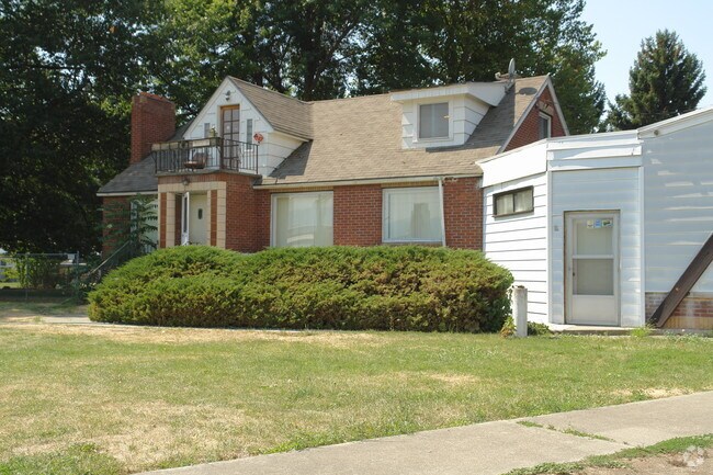
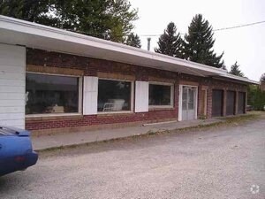
Property Record
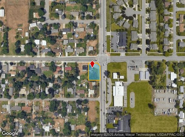
1519 N Barker Rd, Spokane Valley, WA 99016

NEARBY LISTINGS FOR SALE OR LEASE
Property Detail
1519 N Barker Rd
Spokane-Spokane Valley, WA
Valley View Add
55181.1901
VALLEY VIEW ADD N1/2 L1 B9; EXC BEG AT INTERSECTION OF S R/W LN OF MISSION AVE AND W R/W LN OF BARKER RD, TH SLY ALG SD W R/W LN 22.80FT, THE NWLY TO A PT ON SD S R/W LN, TH ELY ALG SD R/W LN 22.80FT TO POB
Storebuilding
Spokane
X
Washington
53063C0595D
1
2025
0.34 AC
2025
Valley
013101
Spokane
3,450 SF
DEMOGRAPHICS near 1519 N Barker Rd
1 Mile
3 Mile
5 Mile
2024 Total Population
9,434
46,787
105,442
2029 Population
10,279
50,454
112,973
Pop Growth 2024-2029
+ 8.96%
+ 7.84%
+ 7.14%
Average Age
40
40
40
2024 Total Households
3,871
18,577
41,712
HH Growth 2024-2029
+ 9.09%
+ 8.00%
+ 7.34%
Median Household Inc
$66,640
$72,325
$69,613
Avg Household Size
2.40
2.50
2.50
2024 Avg HH Vehicles
2.00
2.00
2.00
Median Home Value
$351,125
$385,670
$378,953
Median Year Built
2001
1998
1991
Nearby Places
Map Layers
Map Styles
 Street
 Aerial
- Restaurants
- Banks
- Shops
- Fitness
- Groceries
PUBLIC TRANSPORTATION
AIRPORT
Spokane International
DRIVE
WALK
Distance
Spokane International
26 min
19.3 mi
Freight Ports
Port of Everett
DRIVE
WALK
Distance
Port of Everett
354 min
314.9 mi
SALE & LEASE HISTORY
LISTING DATE
SALE/LEASE

Sep 25, 2016
For Lease
Sep 23, 2016
For Sale
Jan 22, 2019
For Lease
Jan 22, 2019
For Sale
Apr 04, 2017
For Sale
Nearby Properties
Address
Land Use
TOTAL SIZE
Lot Size
Zoning
Address
Land Use
TOTAL SIZE
Lot Size
Zoning
2,818,475 SF
466.05 AC
I-2
Address
Land Use
TOTAL SIZE
Lot Size
Zoning
1,326,772 SF
85.91 AC
I-2
Address
Land Use
TOTAL SIZE
Lot Size
Zoning
275,534 SF
67.98 AC
P
Address
Land Use
TOTAL SIZE
Lot Size
Zoning
373,111 SF
12.44 AC
MUC
Address
Land Use
TOTAL SIZE
Lot Size
Zoning
130,380 SF
11.10 AC
MUC
Address
Land Use
TOTAL SIZE
Lot Size
Zoning
237,094 SF
58.56 AC
R-3
Address
Land Use
TOTAL SIZE
Lot Size
Zoning
3,688,247 SF
244.85 AC
I-2
Address
Land Use
TOTAL SIZE
Lot Size
Zoning
296,760 SF
37.61 AC
I-1
Address
Land Use
TOTAL SIZE
Lot Size
Zoning
358,700 SF
16.41 AC
R3
Address
Land Use
TOTAL SIZE
Lot Size
Zoning
270,453 SF
28.62 AC
Address
Land Use
TOTAL SIZE
Lot Size
Zoning
216,965 SF
10.70 AC
MUC
Address
Land Use
TOTAL SIZE
Lot Size
Zoning
227,044 SF
7.20 AC
MUC
Address
Land Use
TOTAL SIZE
Lot Size
Zoning
98,088 SF
13.94 AC
SAP
Address
Land Use
TOTAL SIZE
Lot Size
Zoning
323,993 SF
10.97 AC
MUC
Address
Land Use
TOTAL SIZE
Lot Size
Zoning
197,868 SF
7.15 AC
MUC
Address
Land Use
TOTAL SIZE
Lot Size
Zoning
192,698 SF
9.55 AC
MUC
Address
Land Use
TOTAL SIZE
Lot Size
Zoning
346,589 SF
16.28 AC
MF-2
Address
Land Use
TOTAL SIZE
Lot Size
Zoning
123,400 SF
4.50 AC
MUC
Address
Land Use
TOTAL SIZE
Lot Size
Zoning
133,310 SF
10.93 AC
M2
Address
Land Use
TOTAL SIZE
Lot Size
Zoning
211,011 SF
8.81 AC
CMU
Address
Land Use
TOTAL SIZE
Lot Size
Zoning
139,122 SF
6.17 AC
MUC
Address
Land Use
TOTAL SIZE
Lot Size
Zoning
150,936 SF
9.30 AC
M2
Address
Land Use
TOTAL SIZE
Lot Size
Zoning
138,379 SF
17.39 AC
RC
Address
Land Use
TOTAL SIZE
Lot Size
Zoning
68,928 SF
10.96 AC
R-3
Address
Land Use
TOTAL SIZE
Lot Size
Zoning
231,172 SF
19.20 AC
RC
Address
Land Use
TOTAL SIZE
Lot Size
Zoning
145,884 SF
6.87 AC
M2
Address
Land Use
TOTAL SIZE
Lot Size
Zoning
107,279 SF
7.31 AC
MF-2
Address
Land Use
TOTAL SIZE
Lot Size
Zoning
144,544 SF
9.65 AC
I-1
Address
Land Use
TOTAL SIZE
Lot Size
Zoning
152,033 SF
6.14 AC
MF-2
Address
Land Use
TOTAL SIZE
Lot Size
Zoning
144,349 SF
8.06 AC
I-2
The World's #1 Commercial Real Estate Marketplace
Connect with us
© 2025 CoStar Group
The information above has been obtained from sources believed reliable. While we do not doubt its accuracy we have not verified it and make no guarantee, warranty or representation about it. It is your responsibility to independently confirm its accuracy and completeness. Any projections, opinions, assumptions, or estimates used are for example only and do not represent the current or future performance of the property. The value of this transaction to you depends on tax and other factors which should be evaluated by your tax, financial, and legal advisors. You and your advisors should conduct a careful, independent investigation of the property to determine to your satisfaction the suitability of the property for your needs.