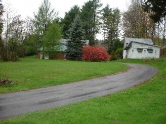
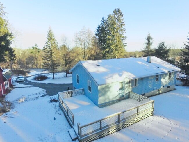
Property Record
1519 State Route 9, Lake George, NY 12845

NEARBY LISTINGS FOR SALE OR LEASE
-
-
View all Lake George listings for sale on LoopNet.com
Property Detail
1519 State Route 9
Glens Falls, NY
RES. 133.50'RF 34.-1-8
523400-288-012-0001-004-000-0000
Warren
Warehouse
New York
2025
4.000
2024
1.15 AC
070604
Warren County
1,824 SF
Albany/Schenectady/Troy
DEMOGRAPHICS near 1519 State Route 9
1 Mile
3 Mile
5 Mile
2024 Total Population
471
10,668
36,216
2029 Population
478
10,633
35,781
Pop Growth 2024-2029
+ 1.49%
(0.33%)
(1.20%)
Average Age
48
46
44
2024 Total Households
196
4,751
15,931
HH Growth 2024-2029
+ 1.53%
(0.25%)
(1.22%)
Median Household Inc
$83,654
$83,317
$75,222
Avg Household Size
2.30
2.10
2.20
2024 Avg HH Vehicles
2.00
2.00
2.00
Median Home Value
$284,126
$274,515
$245,290
Median Year Built
1982
1985
1977
Nearby Places
- Restaurants
- Banks
- Shops
- Fitness
- Groceries
SALE & LEASE HISTORY
LISTING DATE
SALE/LEASE

Feb 23, 2022
For Sale
Apr 01, 2021
For Sale
Nearby Properties
Address
Land Use
TOTAL SIZE
Lot Size
Zoning
Address
Land Use
TOTAL SIZE
Lot Size
Zoning
27,660 SF
130.13 AC
O
Address
Land Use
TOTAL SIZE
Lot Size
Zoning
154,236 SF
104.60 AC
RR-3A
Address
Land Use
TOTAL SIZE
Lot Size
Zoning
Address
Land Use
TOTAL SIZE
Lot Size
Zoning
216,921 SF
10.76 AC
CI
Address
Land Use
TOTAL SIZE
Lot Size
Zoning
116,357 SF
34.05 AC
PUD
Address
Land Use
TOTAL SIZE
Lot Size
Zoning
6,112 SF
28.50 AC
O
Address
Land Use
TOTAL SIZE
Lot Size
Zoning
Address
Land Use
TOTAL SIZE
Lot Size
Zoning
3,060 SF
129.15 AC
RC
Address
Land Use
TOTAL SIZE
Lot Size
Zoning
27,470 SF
14.76 AC
MDR
Address
Land Use
TOTAL SIZE
Lot Size
Zoning
31,456 SF
15.49 AC
MDR
Address
Land Use
TOTAL SIZE
Lot Size
Zoning
89,151 SF
16.53 AC
O
Address
Land Use
TOTAL SIZE
Lot Size
Zoning
215,447 SF
17.74 AC
CI
Address
Land Use
TOTAL SIZE
Lot Size
Zoning
130,142 SF
20.71 AC
CI
Address
Land Use
TOTAL SIZE
Lot Size
Zoning
117,258 SF
54.25 AC
MDR
Address
Land Use
TOTAL SIZE
Lot Size
Zoning
Address
Land Use
TOTAL SIZE
Lot Size
Zoning
71,996 SF
40.15 AC
RR-3A
Address
Land Use
TOTAL SIZE
Lot Size
Zoning
86,968 SF
7.05 AC
CI
Address
Land Use
TOTAL SIZE
Lot Size
Zoning
53,853 SF
5.99 AC
CI
Address
Land Use
TOTAL SIZE
Lot Size
Zoning
9,678 SF
11.46 AC
O
Address
Land Use
TOTAL SIZE
Lot Size
Zoning
49,615 SF
6.21 AC
CI
Address
Land Use
TOTAL SIZE
Lot Size
Zoning
56,924 SF
3.45 AC
07 - MIXED
Address
Land Use
TOTAL SIZE
Lot Size
Zoning
4,800 SF
237.64 AC
LC-42A
Address
Land Use
TOTAL SIZE
Lot Size
Zoning
59,690 SF
6.27 AC
05 - COMME
Address
Land Use
TOTAL SIZE
Lot Size
Zoning
69,646 SF
4.96 AC
CI
Address
Land Use
TOTAL SIZE
Lot Size
Zoning
45,645 SF
6 AC
CI
Address
Land Use
TOTAL SIZE
Lot Size
Zoning
94,992 SF
10.62 AC
CI
Address
Land Use
TOTAL SIZE
Lot Size
Zoning
696 SF
55.11 AC
MDR
Address
Land Use
TOTAL SIZE
Lot Size
Zoning
55,417 SF
12.88 AC
O
Address
Land Use
TOTAL SIZE
Lot Size
Zoning
Address
Land Use
TOTAL SIZE
Lot Size
Zoning
1,600 SF
38.51 AC
CI
The World's #1 Commercial Real Estate Marketplace
Connect with us
© 2025 CoStar Group
The information above has been obtained from sources believed reliable. While we do not doubt its accuracy we have not verified it and make no guarantee, warranty or representation about it. It is your responsibility to independently confirm its accuracy and completeness. Any projections, opinions, assumptions, or estimates used are for example only and do not represent the current or future performance of the property. The value of this transaction to you depends on tax and other factors which should be evaluated by your tax, financial, and legal advisors. You and your advisors should conduct a careful, independent investigation of the property to determine to your satisfaction the suitability of the property for your needs.