Property Record
152 American Dr, Oakboro, NC 28129
NEARBY LISTINGS FOR SALE OR LEASE
-
-
View all Oakboro listings for sale on LoopNet.com
Property Detail
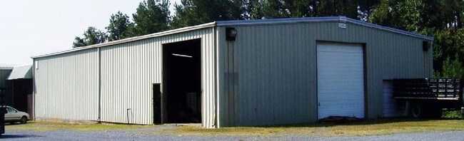
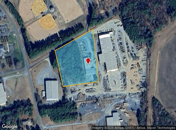
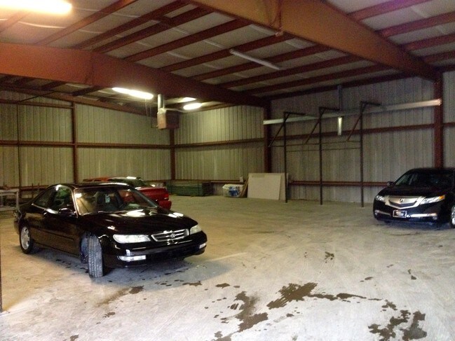
152 American Dr
6503-02-65-7847
Survey For Construction And Preventative
Warehouse
BLDG 152 AMERICAN DR 650300023
X
Stanly
3710650300J
North Carolina
2025
4.64 AC
2025
Stanly County
930901
Charlotte
12,000 SF
Albemarle, NC
DEMOGRAPHICS near 152 American Dr
1 Mile
3 Mile
5 Mile
2024 Total Population
704
3,916
8,351
2029 Population
763
4,207
9,026
Pop Growth 2024-2029
+ 8.38%
+ 7.43%
+ 8.08%
Average Age
42
41
41
2024 Total Households
288
1,572
3,305
HH Growth 2024-2029
+ 7.99%
+ 7.25%
+ 7.90%
Median Household Inc
$68,863
$67,176
$65,925
Avg Household Size
2.50
2.50
2.50
2024 Avg HH Vehicles
3.00
2.00
2.00
Median Home Value
$241,428
$227,864
$226,254
Median Year Built
1974
1977
1983
Nearby Places
Map Layers
Map Styles
 Street
 Aerial
- Restaurants
- Banks
- Shops
- Fitness
- Groceries
PUBLIC TRANSPORTATION
AIRPORT
Concord-Padgett Regional
DRIVE
WALK
Distance
Concord-Padgett Regional
56 min
37.2 mi
SALE & LEASE HISTORY
LISTING DATE
SALE/LEASE

Sep 23, 2016
For Sale
Feb 16, 2018
For Sale
Dec 14, 2017
For Sale
Nearby Properties
Address
Land Use
TOTAL SIZE
Lot Size
Zoning
Address
Land Use
TOTAL SIZE
Lot Size
Zoning
502,619 SF
304.52 AC
R-A
Address
Land Use
TOTAL SIZE
Lot Size
Zoning
132,022 SF
162.56 AC
I
Address
Land Use
TOTAL SIZE
Lot Size
Zoning
40,059 SF
14.23 AC
R-20
Address
Land Use
TOTAL SIZE
Lot Size
Zoning
42,685 SF
6.91 AC
MULTIPLE
Address
Land Use
TOTAL SIZE
Lot Size
Zoning
11,034 SF
13.50 AC
I
Address
Land Use
TOTAL SIZE
Lot Size
Zoning
198,569 SF
15.40 AC
I
Address
Land Use
TOTAL SIZE
Lot Size
Zoning
1,421 SF
44.47 AC
I
Address
Land Use
TOTAL SIZE
Lot Size
Zoning
63,750 SF
9.33 AC
I
Address
Land Use
TOTAL SIZE
Lot Size
Zoning
27,000 SF
8.62 AC
I
Address
Land Use
TOTAL SIZE
Lot Size
Zoning
13,909 SF
3.21 AC
Address
Land Use
TOTAL SIZE
Lot Size
Zoning
43.19 AC
R-A
Address
Land Use
TOTAL SIZE
Lot Size
Zoning
9,785 SF
9.30 AC
R-20
Address
Land Use
TOTAL SIZE
Lot Size
Zoning
55,625 SF
13.23 AC
I
Address
Land Use
TOTAL SIZE
Lot Size
Zoning
12,859 SF
12.61 AC
I
Address
Land Use
TOTAL SIZE
Lot Size
Zoning
6,456 SF
2 AC
Address
Land Use
TOTAL SIZE
Lot Size
Zoning
12,188 SF
1.64 AC
R-20
Address
Land Use
TOTAL SIZE
Lot Size
Zoning
6,849 SF
0.91 AC
C-B
Address
Land Use
TOTAL SIZE
Lot Size
Zoning
11,874 SF
0.48 AC
C-B
Address
Land Use
TOTAL SIZE
Lot Size
Zoning
2,240 SF
13.85 AC
I
Address
Land Use
TOTAL SIZE
Lot Size
Zoning
9,373 SF
1.34 AC
H-B
Address
Land Use
TOTAL SIZE
Lot Size
Zoning
11,220 SF
1.41 AC
R-20
Address
Land Use
TOTAL SIZE
Lot Size
Zoning
56,437 SF
11.53 AC
I
Address
Land Use
TOTAL SIZE
Lot Size
Zoning
7,773 SF
1.05 AC
R-9
Address
Land Use
TOTAL SIZE
Lot Size
Zoning
26,800 SF
4.64 AC
I
Address
Land Use
TOTAL SIZE
Lot Size
Zoning
4,982 SF
8.09 AC
R-20
Address
Land Use
TOTAL SIZE
Lot Size
Zoning
19,762 SF
9.16 AC
MULTIPLE
Address
Land Use
TOTAL SIZE
Lot Size
Zoning
4,990 SF
3.84 AC
R-20
Address
Land Use
TOTAL SIZE
Lot Size
Zoning
3,982 SF
0.91 AC
H-B
Address
Land Use
TOTAL SIZE
Lot Size
Zoning
3,293 SF
0.74 AC
C-B
Address
Land Use
TOTAL SIZE
Lot Size
Zoning
2,812 SF
3.91 AC
The World's #1 Commercial Real Estate Marketplace
Connect with us
© 2026 CoStar Group
The information above has been obtained from sources believed reliable. While we do not doubt its accuracy we have not verified it and make no guarantee, warranty or representation about it. It is your responsibility to independently confirm its accuracy and completeness. Any projections, opinions, assumptions, or estimates used are for example only and do not represent the current or future performance of the property. The value of this transaction to you depends on tax and other factors which should be evaluated by your tax, financial, and legal advisors. You and your advisors should conduct a careful, independent investigation of the property to determine to your satisfaction the suitability of the property for your needs.