Property Record
152 Colebrook River Rd, Winsted, CT 06098
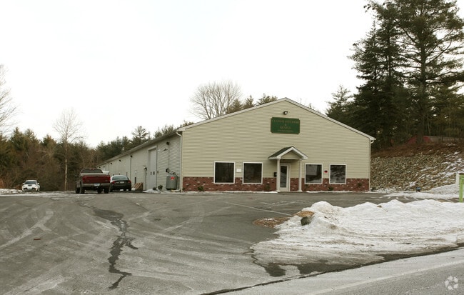

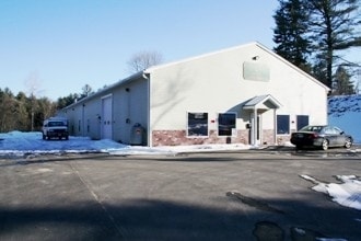
Property Detail
152 Colebrook River Rd
WINC-000006-000150-000005A
LITCHFIELD
Commercialbuilding
Connecticut
IB-1
5a
2025
2 AC
2025
Rt 8/Winsted
320102
Hartford
10,000 SF
Torrington, CT
NEARBY LISTINGS FOR SALE OR LEASE
-
-
View all Winsted listings for sale on LoopNet.com
DEMOGRAPHICS near 152 Colebrook River Rd
1 mile
3 mile
5 mile
2025 Total Population
603
7,467
13,734
2030 Population
626
7,557
14,017
Pop Growth 2025-2030
+ 3.81%
+ 1.21%
+ 2.06%
Average Age
44
44
45
2025 Total Households
281
3,397
6,118
HH Growth 2025-2030
+ 3.91%
+ 1.24%
+ 2.09%
Median Household Inc
$79,500
$71,363
$80,952
Avg Household Size
2.10
2.10
2.20
2025 Avg HH Vehicles
2.00
2.00
2.00
Median Home Value
$279,486
$257,277
$295,040
Median Year Built
1964
1951
1957
Nearby Places
Map Layers
Map Styles
 Street
 Aerial
Transit
 Traffic
 Biking
Places
Listings with unknown addresses are not visible on the map
- Restaurants
- Banks
- Shops
- Fitness
- Groceries
PUBLIC TRANSPORTATION
AIRPORT
Bradley International
Drive
Walk
Distance
Bradley International
57 min
28.0 mi
Freight Ports
Port of New Haven
Drive
Walk
Distance
Port of New Haven
80 min
56.3 mi
Nearby Properties
Address
Land Use
TOTAL SIZE
Lot Size
Zoning
Address
Land Use
TOTAL SIZE
Lot Size
Zoning
1,500 SF
2,295.68 AC
GB
Address
Land Use
TOTAL SIZE
Lot Size
Zoning
95,810 SF
5.60 AC
R-3
Address
Land Use
TOTAL SIZE
Lot Size
Zoning
76,339 SF
124.53 AC
R-1
Address
Land Use
TOTAL SIZE
Lot Size
Zoning
56,852 SF
3 AC
R-3
Address
Land Use
TOTAL SIZE
Lot Size
Zoning
54,920 SF
11.87 AC
R-3
Address
Land Use
TOTAL SIZE
Lot Size
Zoning
5.11 AC
R-3
Address
Land Use
TOTAL SIZE
Lot Size
Zoning
2.32 AC
CB-2
Address
Land Use
TOTAL SIZE
Lot Size
Zoning
9,976 SF
13.10 AC
RU-2
Address
Land Use
TOTAL SIZE
Lot Size
Zoning
32,000 SF
6.33 AC
IB-1
Address
Land Use
TOTAL SIZE
Lot Size
Zoning
7,888 SF
8.72 AC
RU-2
Address
Land Use
TOTAL SIZE
Lot Size
Zoning
2.21 AC
IB-1
Address
Land Use
TOTAL SIZE
Lot Size
Zoning
50,068 SF
1.97 AC
R-3
Address
Land Use
TOTAL SIZE
Lot Size
Zoning
24,000 SF
0.44 AC
CB-2
Address
Land Use
TOTAL SIZE
Lot Size
Zoning
120,472 SF
28.82 AC
IA-1
Address
Land Use
TOTAL SIZE
Lot Size
Zoning
42,850 SF
0.36 AC
CB-3
Address
Land Use
TOTAL SIZE
Lot Size
Zoning
45 AC
RU-1
Address
Land Use
TOTAL SIZE
Lot Size
Zoning
3.17 AC
IB-3
Address
Land Use
TOTAL SIZE
Lot Size
Zoning
10,125 SF
1.34 AC
CB-2
Address
Land Use
TOTAL SIZE
Lot Size
Zoning
28,226 SF
0.96 AC
CX
Address
Land Use
TOTAL SIZE
Lot Size
Zoning
38,896 SF
0.96 AC
IB-1
Address
Land Use
TOTAL SIZE
Lot Size
Zoning
88,168 SF
14.59 AC
IA-1
Address
Land Use
TOTAL SIZE
Lot Size
Zoning
81,171 SF
17.55 AC
IB-1
Address
Land Use
TOTAL SIZE
Lot Size
Zoning
2.16 AC
R-3
Address
Land Use
TOTAL SIZE
Lot Size
Zoning
49,355 SF
13.57 AC
IA-1
Address
Land Use
TOTAL SIZE
Lot Size
Zoning
11,584 SF
1.22 AC
R-3
Address
Land Use
TOTAL SIZE
Lot Size
Zoning
70,633 SF
7.59 AC
IA-1
Address
Land Use
TOTAL SIZE
Lot Size
Zoning
69,092 SF
18.40 AC
IA-1
Address
Land Use
TOTAL SIZE
Lot Size
Zoning
3,712 SF
226 AC
R-1
Address
Land Use
TOTAL SIZE
Lot Size
Zoning
10,982 SF
0.99 AC
R-2
Address
Land Use
TOTAL SIZE
Lot Size
Zoning
19,192 SF
5.99 AC
R2
The World's #1 Commercial Real Estate Marketplace
Connect with us
© 2026 CoStar Group
The information above has been obtained from sources believed reliable. While we do not doubt its accuracy we have not verified it and make no guarantee, warranty or representation about it. It is your responsibility to independently confirm its accuracy and completeness. Any projections, opinions, assumptions, or estimates used are for example only and do not represent the current or future performance of the property. The value of this transaction to you depends on tax and other factors which should be evaluated by your tax, financial, and legal advisors. You and your advisors should conduct a careful, independent investigation of the property to determine to your satisfaction the suitability of the property for your needs.