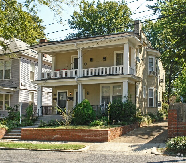
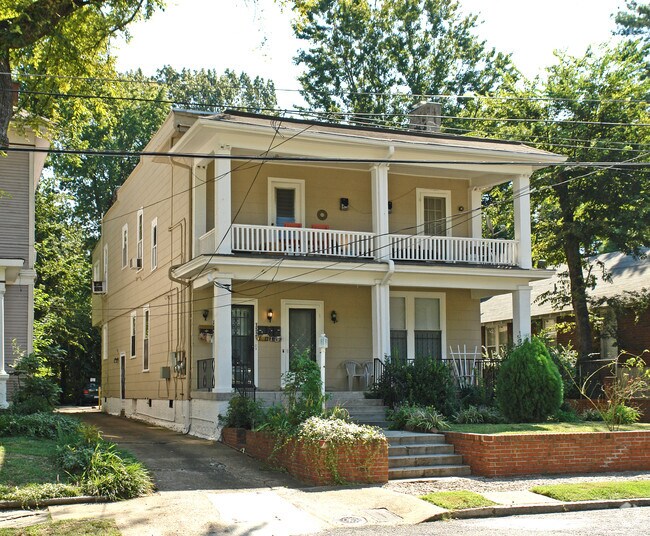
Property Record
152 N Tucker St, Memphis, TN 38104
NEARBY LISTINGS FOR SALE OR LEASE
Property Detail
152 N Tucker St
Memphis, TN-MS-AR
East End Park Place
01-7058-0-0040
ES N TUCKER 217.5 FT S OF POPLAR
Officebuilding
Shelby
X
Tennessee
47157C0290F
8
2024
0.17 AC
2025
Midtown Memphis
003200
Memphis
3,312 SF
DEMOGRAPHICS near 152 N Tucker St
1 Mile
3 Mile
5 Mile
2024 Total Population
15,095
110,877
235,838
2029 Population
15,081
111,795
237,212
Pop Growth 2024-2029
(0.09%)
+ 0.83%
+ 0.58%
Average Age
39
39
38
2024 Total Households
7,872
49,682
102,602
HH Growth 2024-2029
+ 0.03%
+ 0.67%
+ 0.43%
Median Household Inc
$59,139
$39,106
$40,451
Avg Household Size
1.80
2.10
2.20
2024 Avg HH Vehicles
1.00
1.00
1.00
Median Home Value
$357,107
$202,791
$148,006
Median Year Built
1949
1954
1957
Nearby Places
Map Layers
Map Styles
 Street
 Aerial
- Restaurants
- Banks
- Shops
- Fitness
- Groceries
PUBLIC TRANSPORTATION
COMMUTER RAIL
Central Station (Riverfront Loop - Memphis Area Transit Authority Trolley (MataTrolley))
DRIVE
WALK
Distance
Central Station (Riverfront Loop - Memphis Area Transit Authority Trolley (MataTrolley))
9 min
4.7 mi
AIRPORT
Memphis International
DRIVE
WALK
Distance
Memphis International
17 min
8.3 mi
Nearby Properties
Address
Land Use
TOTAL SIZE
Lot Size
Zoning
Address
Land Use
TOTAL SIZE
Lot Size
Zoning
409,950 SF
5.16 AC
CMP-1
Address
Land Use
TOTAL SIZE
Lot Size
Zoning
660,788 SF
8.28 AC
CMP-1
Address
Land Use
TOTAL SIZE
Lot Size
Zoning
61,983 SF
3.95 AC
U
Address
Land Use
TOTAL SIZE
Lot Size
Zoning
413,375 SF
33.87 AC
U
Address
Land Use
TOTAL SIZE
Lot Size
Zoning
300,225 SF
9.61 AC
U
Address
Land Use
TOTAL SIZE
Lot Size
Zoning
138,093 SF
7.05 AC
EMP
Address
Land Use
TOTAL SIZE
Lot Size
Zoning
218,327 SF
4.89 AC
R-6
Address
Land Use
TOTAL SIZE
Lot Size
Zoning
516,768 SF
6.11 AC
CMP-1
Address
Land Use
TOTAL SIZE
Lot Size
Zoning
79,200 SF
1.91 AC
CMP-1
Address
Land Use
TOTAL SIZE
Lot Size
Zoning
99,590 SF
1.73 AC
SE
Address
Land Use
TOTAL SIZE
Lot Size
Zoning
116,399 SF
4.30 AC
SDR
Address
Land Use
TOTAL SIZE
Lot Size
Zoning
115,053 SF
4.63 AC
CMU-1
Address
Land Use
TOTAL SIZE
Lot Size
Zoning
2,137 SF
346 AC
R-15
Address
Land Use
TOTAL SIZE
Lot Size
Zoning
109,000 SF
1.18 AC
SE
Address
Land Use
TOTAL SIZE
Lot Size
Zoning
43,779 SF
2.11 AC
RU-3
Address
Land Use
TOTAL SIZE
Lot Size
Zoning
82,064 SF
3.53 AC
CMP-1
Address
Land Use
TOTAL SIZE
Lot Size
Zoning
99,732 SF
1.08 AC
CMU-3
Address
Land Use
TOTAL SIZE
Lot Size
Zoning
100,246 SF
0.93 AC
CMU-3
Address
Land Use
TOTAL SIZE
Lot Size
Zoning
33,391 SF
1.26 AC
CMU-1
Address
Land Use
TOTAL SIZE
Lot Size
Zoning
110,072 SF
1.38 AC
SE
Address
Land Use
TOTAL SIZE
Lot Size
Zoning
87,504 SF
0.88 AC
CMU-3
Address
Land Use
TOTAL SIZE
Lot Size
Zoning
222,671 SF
8.77 AC
EMP
Address
Land Use
TOTAL SIZE
Lot Size
Zoning
66,004 SF
0.51 AC
SE
Address
Land Use
TOTAL SIZE
Lot Size
Zoning
53,088 SF
1.51 AC
CMU-3
Address
Land Use
TOTAL SIZE
Lot Size
Zoning
38,348 SF
1.74 AC
RW
Address
Land Use
TOTAL SIZE
Lot Size
Zoning
26,580 SF
3.13 AC
RU-4
Address
Land Use
TOTAL SIZE
Lot Size
Zoning
120.15 AC
RU-1
Address
Land Use
TOTAL SIZE
Lot Size
Zoning
38,409 SF
0.43 AC
SE
Address
Land Use
TOTAL SIZE
Lot Size
Zoning
114,326 SF
1.99 AC
R-6
Address
Land Use
TOTAL SIZE
Lot Size
Zoning
18,014 SF
1.28 AC
HDR
The World's #1 Commercial Real Estate Marketplace
Connect with us
© 2026 CoStar Group
The information above has been obtained from sources believed reliable. While we do not doubt its accuracy we have not verified it and make no guarantee, warranty or representation about it. It is your responsibility to independently confirm its accuracy and completeness. Any projections, opinions, assumptions, or estimates used are for example only and do not represent the current or future performance of the property. The value of this transaction to you depends on tax and other factors which should be evaluated by your tax, financial, and legal advisors. You and your advisors should conduct a careful, independent investigation of the property to determine to your satisfaction the suitability of the property for your needs.