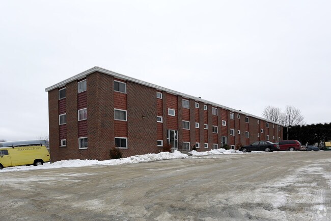
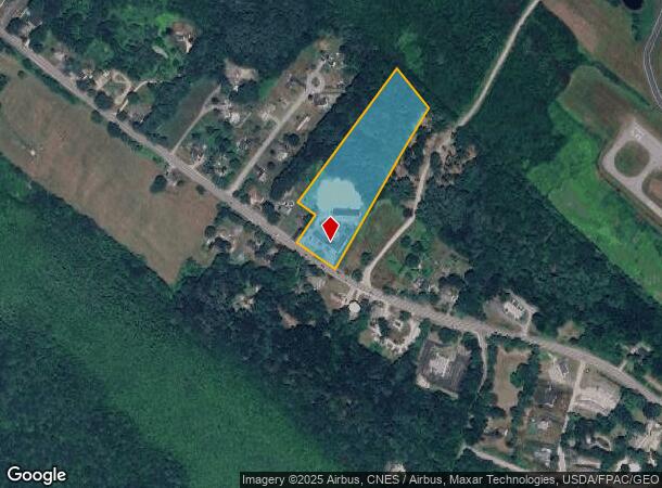
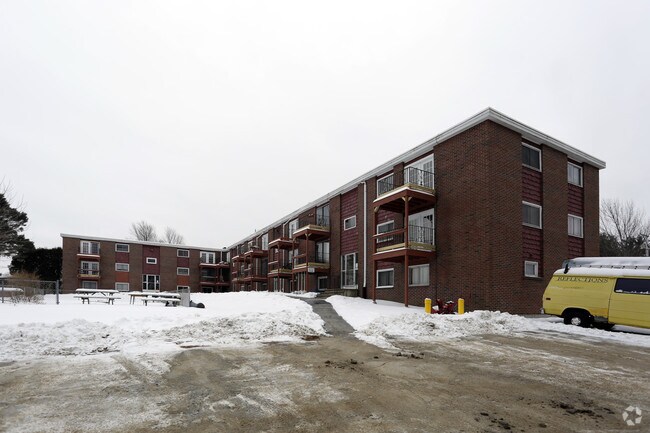
Property Record
152 Rochester Hill Rd, Rochester, NH 03867
NEARBY LISTINGS FOR SALE OR LEASE
Property Detail
152 Rochester Hill Rd
Apartment
Strafford
X
New Hampshire
33017C0212D
6.73 AC
2024
Strafford County
2024
Boston
084100
Boston-Cambridge-Newton, MA-NH
29,421 SF
RCHE-000243-000012
DEMOGRAPHICS near 152 Rochester Hill Rd
1 Mile
3 Mile
5 Mile
2024 Total Population
1,693
24,855
52,814
2029 Population
1,750
26,070
55,306
Pop Growth 2024-2029
+ 3.37%
+ 4.89%
+ 4.72%
Average Age
44
43
42
2024 Total Households
651
10,494
21,815
HH Growth 2024-2029
+ 3.53%
+ 4.96%
+ 4.79%
Median Household Inc
$105,334
$78,511
$84,934
Avg Household Size
2.50
2.30
2.30
2024 Avg HH Vehicles
2.00
2.00
2.00
Median Home Value
$262,867
$243,149
$262,433
Median Year Built
1975
1975
1978
Nearby Places
- Restaurants
- Banks
- Shops
- Fitness
- Groceries
PUBLIC TRANSPORTATION
COMMUTER RAIL
Dover (Downeaster - Amtrak)
DRIVE
WALK
Distance
Dover (Downeaster - Amtrak)
17 min
7.7 mi
AIRPORT
Portsmouth International at Pease
DRIVE
WALK
Distance
Portsmouth International at Pease
31 min
17.8 mi
Freight Ports
Portland, ME
DRIVE
WALK
Distance
Portland, ME
72 min
50.8 mi
Nearby Properties
Address
Land Use
TOTAL SIZE
Lot Size
Zoning
Address
Land Use
TOTAL SIZE
Lot Size
Zoning
483,789 SF
37 AC
R2
Address
Land Use
TOTAL SIZE
Lot Size
Zoning
Address
Land Use
TOTAL SIZE
Lot Size
Zoning
345,277 SF
49.30 AC
IND
Address
Land Use
TOTAL SIZE
Lot Size
Zoning
219,360 SF
6.23 AC
HSP
Address
Land Use
TOTAL SIZE
Lot Size
Zoning
277,667 SF
45.36 AC
HC
Address
Land Use
TOTAL SIZE
Lot Size
Zoning
207,125 SF
22 AC
R2
Address
Land Use
TOTAL SIZE
Lot Size
Zoning
428,428 SF
210.42 AC
CI
Address
Land Use
TOTAL SIZE
Lot Size
Zoning
1,273 SF
29.90 AC
R2
Address
Land Use
TOTAL SIZE
Lot Size
Zoning
77,916 SF
6.58 AC
A
Address
Land Use
TOTAL SIZE
Lot Size
Zoning
86,420 SF
3.30 AC
DTC
Address
Land Use
TOTAL SIZE
Lot Size
Zoning
9.53 AC
R1
Address
Land Use
TOTAL SIZE
Lot Size
Zoning
2.41 AC
Address
Land Use
TOTAL SIZE
Lot Size
Zoning
97,792 SF
23.89 AC
R1
Address
Land Use
TOTAL SIZE
Lot Size
Zoning
68,535 SF
7.10 AC
R2
Address
Land Use
TOTAL SIZE
Lot Size
Zoning
236,340 SF
27.68 AC
HC
Address
Land Use
TOTAL SIZE
Lot Size
Zoning
49,146 SF
7.10 AC
R2
Address
Land Use
TOTAL SIZE
Lot Size
Zoning
150,000 SF
29.85 AC
IND
Address
Land Use
TOTAL SIZE
Lot Size
Zoning
53,517 SF
30 AC
A
Address
Land Use
TOTAL SIZE
Lot Size
Zoning
61,063 SF
8.26 AC
R2
Address
Land Use
TOTAL SIZE
Lot Size
Zoning
59,160 SF
10.44 AC
R1
Address
Land Use
TOTAL SIZE
Lot Size
Zoning
33.57 AC
CI
Address
Land Use
TOTAL SIZE
Lot Size
Zoning
4,916 SF
93 AC
A
Address
Land Use
TOTAL SIZE
Lot Size
Zoning
82,752 SF
9.88 AC
R2
Address
Land Use
TOTAL SIZE
Lot Size
Zoning
51,968 SF
5.40 AC
R2
Address
Land Use
TOTAL SIZE
Lot Size
Zoning
44,530 SF
2.03 AC
A
Address
Land Use
TOTAL SIZE
Lot Size
Zoning
44,530 SF
5.67 AC
A
Address
Land Use
TOTAL SIZE
Lot Size
Zoning
90,112 SF
7.88 AC
CI
Address
Land Use
TOTAL SIZE
Lot Size
Zoning
66,786 SF
2.41 AC
R2
Address
Land Use
TOTAL SIZE
Lot Size
Zoning
14,552 SF
18 AC
R2
Address
Land Use
TOTAL SIZE
Lot Size
Zoning
289 AC
IND
The World's #1 Commercial Real Estate Marketplace
Connect with us
© 2025 CoStar Group
The information above has been obtained from sources believed reliable. While we do not doubt its accuracy we have not verified it and make no guarantee, warranty or representation about it. It is your responsibility to independently confirm its accuracy and completeness. Any projections, opinions, assumptions, or estimates used are for example only and do not represent the current or future performance of the property. The value of this transaction to you depends on tax and other factors which should be evaluated by your tax, financial, and legal advisors. You and your advisors should conduct a careful, independent investigation of the property to determine to your satisfaction the suitability of the property for your needs.