Property Record
1520 Fillmore St, Twin Falls, ID 83301
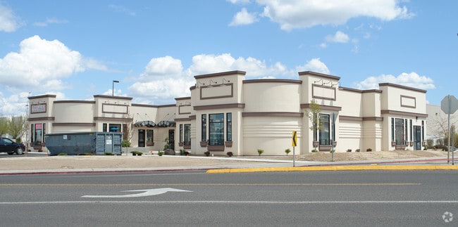

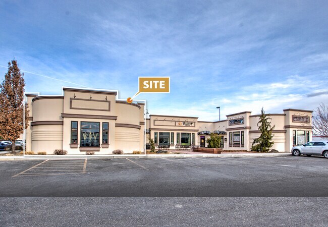
Property Detail
1520 Fillmore St
RPT0352002015AA
TWIN FALLS BRECKENRIDGE FARMS PHASE 2 1ST AMD LOT 15 BLOCK 2, EXC N 11.40 (4-10-17 NE)
Storebuilding
Twin Falls
C-1
Idaho
B and X Area of moderate flood hazard, usually the area between the limits of the 100-year and 500-year floods.
15
2025
0.83 AC
2025
Idaho South Area
000800
Other Market Areas
7,830 SF
Twin Falls, ID
NEARBY LISTINGS FOR SALE OR LEASE
DEMOGRAPHICS near 1520 Fillmore St
1 mile
3 mile
5 mile
2024 Total Population
6,328
51,346
65,799
2029 Population
6,717
54,201
69,479
Pop Growth 2024-2029
+ 6.15%
+ 5.56%
+ 5.59%
Average Age
40
38
38
2024 Total Households
2,262
19,119
24,300
HH Growth 2024-2029
+ 6.45%
+ 5.66%
+ 5.68%
Median Household Inc
$74,038
$65,443
$66,986
Avg Household Size
2.60
2.60
2.60
2024 Avg HH Vehicles
2.00
2.00
2.00
Median Home Value
$360,893
$328,883
$332,583
Median Year Built
1993
1979
1988
Nearby Places
Map Layers
Map Styles
 Street
 Aerial
Transit
 Traffic
 Biking
Places
Listings with unknown addresses are not visible on the map
- Restaurants
- Banks
- Shops
- Fitness
- Groceries
SALE & LEASE HISTORY
LISTING DATE
SALE/LEASE

Sep 25, 2016
For Lease
Jul 20, 2017
For Lease
Aug 31, 2022
For Lease
Aug 27, 2019
For Lease
Apr 17, 2023
For Lease
Nearby Properties
Address
Land Use
TOTAL SIZE
Lot Size
Zoning
Address
Land Use
TOTAL SIZE
Lot Size
Zoning
38,811 SF
40.92 AC
C-1
Address
Land Use
TOTAL SIZE
Lot Size
Zoning
6,384 SF
5.89 AC
M-2
Address
Land Use
TOTAL SIZE
Lot Size
Zoning
225,980 SF
24.47 AC
C-1
Address
Land Use
TOTAL SIZE
Lot Size
Zoning
382,261 SF
11.44 AC
M-2
Address
Land Use
TOTAL SIZE
Lot Size
Zoning
35,638 SF
15.98 AC
C-1
Address
Land Use
TOTAL SIZE
Lot Size
Zoning
8.53 AC
C-1
Address
Land Use
TOTAL SIZE
Lot Size
Zoning
28,224 SF
7.10 AC
C-1
Address
Land Use
TOTAL SIZE
Lot Size
Zoning
48,191 SF
3.46 AC
C-1
Address
Land Use
TOTAL SIZE
Lot Size
Zoning
167,708 SF
14.90 AC
C-1
Address
Land Use
TOTAL SIZE
Lot Size
Zoning
24,284 SF
3.68 AC
C-1
Address
Land Use
TOTAL SIZE
Lot Size
Zoning
100,034 SF
8.01 AC
C-1
Address
Land Use
TOTAL SIZE
Lot Size
Zoning
160,432 SF
11.25 AC
C-1
Address
Land Use
TOTAL SIZE
Lot Size
Zoning
137,048 SF
12.66 AC
C-1
Address
Land Use
TOTAL SIZE
Lot Size
Zoning
71,798 SF
5.97 AC
C-1
Address
Land Use
TOTAL SIZE
Lot Size
Zoning
76,913 SF
2.88 AC
C-1
Address
Land Use
TOTAL SIZE
Lot Size
Zoning
240,740 SF
6.74 AC
M-2
Address
Land Use
TOTAL SIZE
Lot Size
Zoning
91,588 SF
3.16 AC
C-1
Address
Land Use
TOTAL SIZE
Lot Size
Zoning
116,676 SF
12.13 AC
C-1
Address
Land Use
TOTAL SIZE
Lot Size
Zoning
48,730 SF
4.67 AC
C-1
Address
Land Use
TOTAL SIZE
Lot Size
Zoning
9,440 SF
7.05 AC
R-6
Address
Land Use
TOTAL SIZE
Lot Size
Zoning
71,900 SF
2.67 AC
C-1
Address
Land Use
TOTAL SIZE
Lot Size
Zoning
114,844 SF
7.70 AC
C-1
Address
Land Use
TOTAL SIZE
Lot Size
Zoning
20,016 SF
4.40 AC
R-6
Address
Land Use
TOTAL SIZE
Lot Size
Zoning
65,565 SF
2.14 AC
C-1
Address
Land Use
TOTAL SIZE
Lot Size
Zoning
40,730 SF
0.36 AC
O-T
Address
Land Use
TOTAL SIZE
Lot Size
Zoning
78,849 SF
18.66 AC
M-2
Address
Land Use
TOTAL SIZE
Lot Size
Zoning
24,650 SF
2.13 AC
C-1
Address
Land Use
TOTAL SIZE
Lot Size
Zoning
9,220 SF
5.92 AC
R-4
Address
Land Use
TOTAL SIZE
Lot Size
Zoning
5,234 SF
5 AC
R-6
Address
Land Use
TOTAL SIZE
Lot Size
Zoning
27,652 SF
4.64 AC
C-1
The World's #1 Commercial Real Estate Marketplace
Connect with us
© 2026 CoStar Group
The information above has been obtained from sources believed reliable. While we do not doubt its accuracy we have not verified it and make no guarantee, warranty or representation about it. It is your responsibility to independently confirm its accuracy and completeness. Any projections, opinions, assumptions, or estimates used are for example only and do not represent the current or future performance of the property. The value of this transaction to you depends on tax and other factors which should be evaluated by your tax, financial, and legal advisors. You and your advisors should conduct a careful, independent investigation of the property to determine to your satisfaction the suitability of the property for your needs.