Property Record
1532 Industrial Blvd, Birmingham, AL 35221
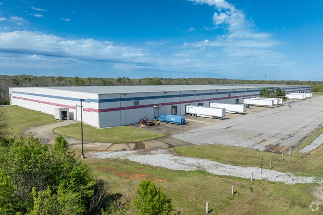
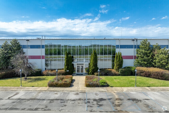
This Property Is For Sale
Current Lease Availabilities
Industrial LEASE
Negotiable
100,000 - 307,200 SF
NEARBY LISTINGS FOR SALE OR LEASE
Property Detail
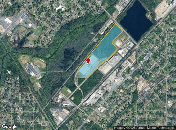
1532 Industrial Blvd
Birmingham-Hoover, AL
Midfield Southern Ind Pk
30-00-24-4-004-001.002
THAT PART OF LOT A MIDFIELD SOUTHERN INDUSTRIAL PARK LYING IN SE4 OF SEC 24 LESS & EXCEPT LOT 2-A RESURVEY PART OF LOT A MIDFIELD SOUTHERN INDUSTRIAL PARK WHCH IS NE CORNER
Warehouse
Jefferson
X
Alabama
01073C0533G
a
2023
39.40 AC
2024
Bessemer
013200
Birmingham
288,000 SF
DEMOGRAPHICS near 1532 Industrial Blvd
1 Mile
3 Mile
5 Mile
2024 Total Population
5,053
47,532
123,763
2029 Population
5,036
47,376
123,275
Pop Growth 2024-2029
(0.34%)
(0.33%)
(0.39%)
Average Age
42
41
40
2024 Total Households
2,162
19,643
52,093
HH Growth 2024-2029
(0.32%)
(0.50%)
(0.44%)
Median Household Inc
$41,515
$40,684
$41,870
Avg Household Size
2.30
2.30
2.30
2024 Avg HH Vehicles
2.00
2.00
2.00
Median Home Value
$66,533
$79,514
$110,510
Median Year Built
1957
1961
1966
Nearby Places
- Restaurants
- Banks
- Shops
- Fitness
- Groceries
PUBLIC TRANSPORTATION
COMMUTER RAIL
Birmingham (Crescent - Amtrak)
DRIVE
WALK
Distance
Birmingham (Crescent - Amtrak)
16 min
8.9 mi
AIRPORT
Birmingham-Shuttlesworth International
DRIVE
WALK
Distance
Birmingham-Shuttlesworth International
24 min
14.0 mi
Freight Ports
Port of Mobile
DRIVE
WALK
Distance
Port of Mobile
288 min
257.6 mi
Nearby Properties
Address
Land Use
TOTAL SIZE
Lot Size
Zoning
Address
Land Use
TOTAL SIZE
Lot Size
Zoning
321,783 SF
19.40 AC
MXD
Address
Land Use
TOTAL SIZE
Lot Size
Zoning
1.77 AC
QO&I
Address
Land Use
TOTAL SIZE
Lot Size
Zoning
1,244,986 SF
I2
Address
Land Use
TOTAL SIZE
Lot Size
Zoning
120,238 SF
10 AC
I3
Address
Land Use
TOTAL SIZE
Lot Size
Zoning
2,573,547 SF
112 AC
I2
Address
Land Use
TOTAL SIZE
Lot Size
Zoning
118,309 SF
88.50 AC
I3
Address
Land Use
TOTAL SIZE
Lot Size
Zoning
96,446 SF
10 AC
I3
Address
Land Use
TOTAL SIZE
Lot Size
Zoning
51,572 SF
494.91 AC
I3
Address
Land Use
TOTAL SIZE
Lot Size
Zoning
202,775 SF
10.40 AC
I3
Address
Land Use
TOTAL SIZE
Lot Size
Zoning
200,650 SF
19.48 AC
R4
Address
Land Use
TOTAL SIZE
Lot Size
Zoning
116,442 SF
2.67 AC
B6
Address
Land Use
TOTAL SIZE
Lot Size
Zoning
72,468 SF
8.70 AC
I3
Address
Land Use
TOTAL SIZE
Lot Size
Zoning
73,033 SF
15.20 AC
R-6
Address
Land Use
TOTAL SIZE
Lot Size
Zoning
35,826 SF
3.77 AC
I-3
Address
Land Use
TOTAL SIZE
Lot Size
Zoning
191,910 SF
13.88 AC
I3
Address
Land Use
TOTAL SIZE
Lot Size
Zoning
68,191 SF
16.20 AC
I3
Address
Land Use
TOTAL SIZE
Lot Size
Zoning
68,191 SF
12.50 AC
I3
Address
Land Use
TOTAL SIZE
Lot Size
Zoning
191,664 SF
14.73 AC
R4
Address
Land Use
TOTAL SIZE
Lot Size
Zoning
88.50 AC
I3
Address
Land Use
TOTAL SIZE
Lot Size
Zoning
145,300 SF
25 AC
R3
Address
Land Use
TOTAL SIZE
Lot Size
Zoning
48,320 SF
7.81 AC
I3
Address
Land Use
TOTAL SIZE
Lot Size
Zoning
46,155 SF
0.77 AC
R4
Address
Land Use
TOTAL SIZE
Lot Size
Zoning
101,671 SF
14.73 AC
B2
Address
Land Use
TOTAL SIZE
Lot Size
Zoning
114,345 SF
11.20 AC
I-3
Address
Land Use
TOTAL SIZE
Lot Size
Zoning
78,252 SF
7.30 AC
I3
Address
Land Use
TOTAL SIZE
Lot Size
Zoning
37,619 SF
9.36 AC
R3
Address
Land Use
TOTAL SIZE
Lot Size
Zoning
29,906 SF
5.40 AC
I3
Address
Land Use
TOTAL SIZE
Lot Size
Zoning
56,036 SF
6.15 AC
I-3
The World's #1 Commercial Real Estate Marketplace
Connect with us
© 2025 CoStar Group
The information above has been obtained from sources believed reliable. While we do not doubt its accuracy we have not verified it and make no guarantee, warranty or representation about it. It is your responsibility to independently confirm its accuracy and completeness. Any projections, opinions, assumptions, or estimates used are for example only and do not represent the current or future performance of the property. The value of this transaction to you depends on tax and other factors which should be evaluated by your tax, financial, and legal advisors. You and your advisors should conduct a careful, independent investigation of the property to determine to your satisfaction the suitability of the property for your needs.