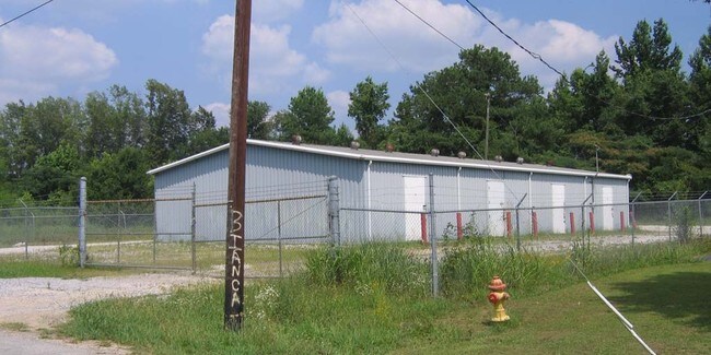
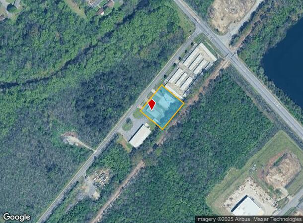
Property Record
1520 Midfield High School Rd, Birmingham, AL 35228
NEARBY LISTINGS FOR SALE OR LEASE
Property Detail
1520 Midfield High School Rd
Birmingham-Hoover, AL
Amended Map Vincent Add
30-00-24-4-002-001.004
LOT 1 AMENDED MAP VINCENT ADD TO MIDFIELD PARK PB 24 PG 95
Warehouse
Jefferson
X
Alabama
01073C0534G
1
2024
0.45 AC
2024
Bessemer
010603
Birmingham
3,200 SF
DEMOGRAPHICS near 1520 Midfield High School Rd
1 Mile
3 Mile
5 Mile
2024 Total Population
5,585
50,741
125,869
2029 Population
5,535
50,581
125,573
Pop Growth 2024-2029
(0.90%)
(0.32%)
(0.24%)
Average Age
42
41
40
2024 Total Households
2,378
20,979
53,121
HH Growth 2024-2029
(0.84%)
(0.47%)
(0.27%)
Median Household Inc
$44,177
$40,422
$41,256
Avg Household Size
2.30
2.30
2.20
2024 Avg HH Vehicles
2.00
2.00
2.00
Median Home Value
$68,079
$77,447
$108,773
Median Year Built
1956
1960
1966
Nearby Places
Map Layers
Map Styles
 Street
 Aerial
- Restaurants
- Banks
- Shops
- Fitness
- Groceries
PUBLIC TRANSPORTATION
AIRPORT
Birmingham-Shuttlesworth International
DRIVE
WALK
Distance
Birmingham-Shuttlesworth International
24 min
15.5 mi
Freight Ports
Port of Mobile
DRIVE
WALK
Distance
Port of Mobile
1 min
201.9 mi
SALE & LEASE HISTORY
LISTING DATE
SALE/LEASE

Sep 24, 2016
For Sale
Nearby Properties
Address
Land Use
TOTAL SIZE
Lot Size
Zoning
Address
Land Use
TOTAL SIZE
Lot Size
Zoning
209,765 SF
19.20 AC
I-3
Address
Land Use
TOTAL SIZE
Lot Size
Zoning
321,783 SF
19.40 AC
MXD
Address
Land Use
TOTAL SIZE
Lot Size
Zoning
1.77 AC
QO&I
Address
Land Use
TOTAL SIZE
Lot Size
Zoning
1,244,986 SF
I2
Address
Land Use
TOTAL SIZE
Lot Size
Zoning
120,238 SF
10 AC
I3
Address
Land Use
TOTAL SIZE
Lot Size
Zoning
2,573,547 SF
112 AC
I2
Address
Land Use
TOTAL SIZE
Lot Size
Zoning
96,446 SF
10 AC
I3
Address
Land Use
TOTAL SIZE
Lot Size
Zoning
51,572 SF
494.91 AC
I3
Address
Land Use
TOTAL SIZE
Lot Size
Zoning
127,240 SF
3.50 AC
R4
Address
Land Use
TOTAL SIZE
Lot Size
Zoning
202,775 SF
10.40 AC
I3
Address
Land Use
TOTAL SIZE
Lot Size
Zoning
200,650 SF
19.48 AC
R4
Address
Land Use
TOTAL SIZE
Lot Size
Zoning
116,442 SF
2.67 AC
B6
Address
Land Use
TOTAL SIZE
Lot Size
Zoning
72,468 SF
8.70 AC
I3
Address
Land Use
TOTAL SIZE
Lot Size
Zoning
73,033 SF
15.20 AC
R-6
Address
Land Use
TOTAL SIZE
Lot Size
Zoning
35,826 SF
3.77 AC
I-3
Address
Land Use
TOTAL SIZE
Lot Size
Zoning
191,910 SF
13.88 AC
I3
Address
Land Use
TOTAL SIZE
Lot Size
Zoning
191,664 SF
14.73 AC
R4
Address
Land Use
TOTAL SIZE
Lot Size
Zoning
48,320 SF
7.81 AC
I3
Address
Land Use
TOTAL SIZE
Lot Size
Zoning
288,000 SF
39.40 AC
I2-I
Address
Land Use
TOTAL SIZE
Lot Size
Zoning
46,155 SF
0.77 AC
R4
Address
Land Use
TOTAL SIZE
Lot Size
Zoning
101,671 SF
14.73 AC
B2
Address
Land Use
TOTAL SIZE
Lot Size
Zoning
114,345 SF
11.20 AC
I-3
Address
Land Use
TOTAL SIZE
Lot Size
Zoning
78,252 SF
7.30 AC
I3
Address
Land Use
TOTAL SIZE
Lot Size
Zoning
37,619 SF
9.36 AC
R3
Address
Land Use
TOTAL SIZE
Lot Size
Zoning
29,906 SF
5.40 AC
I3
Address
Land Use
TOTAL SIZE
Lot Size
Zoning
56,036 SF
6.15 AC
I-3
Address
Land Use
TOTAL SIZE
Lot Size
Zoning
157,183 SF
6.50 AC
B2
Address
Land Use
TOTAL SIZE
Lot Size
Zoning
104,775 SF
9.40 AC
B-2
Address
Land Use
TOTAL SIZE
Lot Size
Zoning
1,437,077 SF
I2
The World's #1 Commercial Real Estate Marketplace
Connect with us
© 2025 CoStar Group
The information above has been obtained from sources believed reliable. While we do not doubt its accuracy we have not verified it and make no guarantee, warranty or representation about it. It is your responsibility to independently confirm its accuracy and completeness. Any projections, opinions, assumptions, or estimates used are for example only and do not represent the current or future performance of the property. The value of this transaction to you depends on tax and other factors which should be evaluated by your tax, financial, and legal advisors. You and your advisors should conduct a careful, independent investigation of the property to determine to your satisfaction the suitability of the property for your needs.