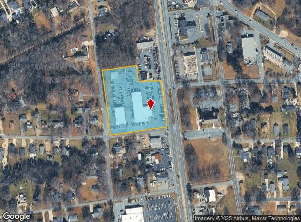
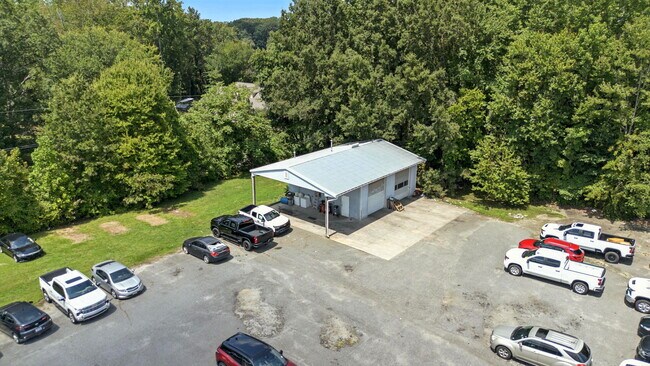
Property Record
1520 S Cannon Blvd, Kannapolis, NC 28083
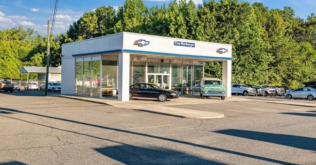
This Property Is For Sale
NEARBY LISTINGS FOR SALE OR LEASE
Property Detail
1520 S Cannon Blvd
5623-00-2911-0000
South Cannon Blvd
Vehiclerentalsvehiclesales
PART LOTS7&11
X
Cabarrus
3710562300K
North Carolina
2025
3.12 AC
2025
Cabarrus County
040900
Charlotte
16,637 SF
Charlotte-Concord-Gastonia, NC-SC
DEMOGRAPHICS near 1520 S Cannon Blvd
1 Mile
3 Mile
5 Mile
2024 Total Population
8,490
55,560
97,707
2029 Population
9,602
62,597
109,502
Pop Growth 2024-2029
+ 13.10%
+ 12.67%
+ 12.07%
Average Age
38
39
39
2024 Total Households
3,323
21,773
38,272
HH Growth 2024-2029
+ 11.68%
+ 11.39%
+ 10.90%
Median Household Inc
$48,333
$56,479
$58,866
Avg Household Size
2.50
2.50
2.50
2024 Avg HH Vehicles
2.00
2.00
2.00
Median Home Value
$172,632
$186,208
$200,530
Median Year Built
1980
1981
1982
Nearby Places
- Restaurants
- Banks
- Shops
- Fitness
- Groceries
PUBLIC TRANSPORTATION
COMMUTER RAIL
Kannapolis Station (Piedmont - North Carolina by Train (NC Train))
DRIVE
WALK
Distance
Kannapolis Station (Piedmont - North Carolina by Train (NC Train))
5 min
2.6 mi
AIRPORT
Concord-Padgett Regional
DRIVE
WALK
Distance
Concord-Padgett Regional
18 min
11.3 mi
Charlotte/Douglas International
DRIVE
WALK
Distance
Charlotte/Douglas International
44 min
31.5 mi
Freight Ports
Port of Wilmington
DRIVE
WALK
Distance
Port of Wilmington
259 min
200.6 mi
Nearby Properties
Address
Land Use
TOTAL SIZE
Lot Size
Zoning
Address
Land Use
TOTAL SIZE
Lot Size
Zoning
280,149 SF
54.88 AC
C-2
Address
Land Use
TOTAL SIZE
Lot Size
Zoning
276,070 SF
CC
Address
Land Use
TOTAL SIZE
Lot Size
Zoning
42,409 SF
16 AC
GC
Address
Land Use
TOTAL SIZE
Lot Size
Zoning
114,382 SF
24.64 AC
R4
Address
Land Use
TOTAL SIZE
Lot Size
Zoning
6,880 SF
18.34 AC
RC
Address
Land Use
TOTAL SIZE
Lot Size
Zoning
176,676 SF
31.80 AC
R4
Address
Land Use
TOTAL SIZE
Lot Size
Zoning
128,064 SF
2.68 AC
CC
Address
Land Use
TOTAL SIZE
Lot Size
Zoning
121,156 SF
3.57 AC
CC
Address
Land Use
TOTAL SIZE
Lot Size
Zoning
106,804 SF
1.81 AC
CC
Address
Land Use
TOTAL SIZE
Lot Size
Zoning
15,156 SF
12.54 AC
RC
Address
Land Use
TOTAL SIZE
Lot Size
Zoning
90,350 SF
10.20 AC
PID
Address
Land Use
TOTAL SIZE
Lot Size
Zoning
44,136 SF
15.42 AC
R18
Address
Land Use
TOTAL SIZE
Lot Size
Zoning
83,152 SF
7.11 AC
CC
Address
Land Use
TOTAL SIZE
Lot Size
Zoning
15,924 SF
16.90 AC
RC
Address
Land Use
TOTAL SIZE
Lot Size
Zoning
24,618 SF
21.33 AC
R18
Address
Land Use
TOTAL SIZE
Lot Size
Zoning
29,957 SF
18.10 AC
PID
Address
Land Use
TOTAL SIZE
Lot Size
Zoning
176,075 SF
2.35 AC
CC
Address
Land Use
TOTAL SIZE
Lot Size
Zoning
279,000 SF
23.48 AC
Address
Land Use
TOTAL SIZE
Lot Size
Zoning
29,259 SF
8.48 AC
RC
Address
Land Use
TOTAL SIZE
Lot Size
Zoning
122,182 SF
16.70 AC
C-2
Address
Land Use
TOTAL SIZE
Lot Size
Zoning
114,250 SF
18.50 AC
RM-2
Address
Land Use
TOTAL SIZE
Lot Size
Zoning
5,308 SF
15.16 AC
RC
Address
Land Use
TOTAL SIZE
Lot Size
Zoning
12,696 SF
9.71 AC
RC
Address
Land Use
TOTAL SIZE
Lot Size
Zoning
13,824 SF
9.78 AC
RC
Address
Land Use
TOTAL SIZE
Lot Size
Zoning
18,288 SF
9.45 AC
RC
Address
Land Use
TOTAL SIZE
Lot Size
Zoning
88,934 SF
8 AC
PID
Address
Land Use
TOTAL SIZE
Lot Size
Zoning
207,899 SF
21.62 AC
C-2
Address
Land Use
TOTAL SIZE
Lot Size
Zoning
85,422 SF
6.30 AC
R8
Address
Land Use
TOTAL SIZE
Lot Size
Zoning
67,862 SF
1.77 AC
CC
Address
Land Use
TOTAL SIZE
Lot Size
Zoning
10,072 SF
12.03 AC
RC
The World's #1 Commercial Real Estate Marketplace
Connect with us
© 2025 CoStar Group
The information above has been obtained from sources believed reliable. While we do not doubt its accuracy we have not verified it and make no guarantee, warranty or representation about it. It is your responsibility to independently confirm its accuracy and completeness. Any projections, opinions, assumptions, or estimates used are for example only and do not represent the current or future performance of the property. The value of this transaction to you depends on tax and other factors which should be evaluated by your tax, financial, and legal advisors. You and your advisors should conduct a careful, independent investigation of the property to determine to your satisfaction the suitability of the property for your needs.