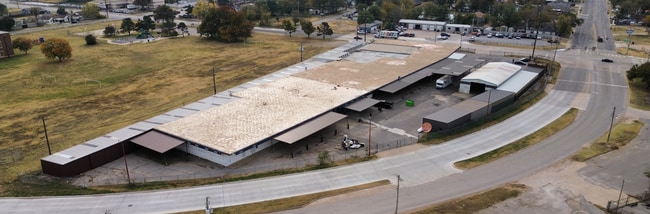
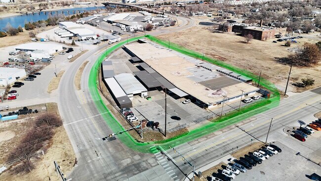
Property Record
1520 S Central Ave, Oklahoma City, OK 73129

Current Lease Availabilities
NEARBY LISTINGS FOR SALE OR LEASE
Property Detail
1520 S Central Ave
131746416
Unpltd Pt Sec 03 11N 3W
Warehouse
UNPLTD PT SEC 03 11N 3W 000 000 PT OF SW4 SEC 3 11N 3W BEG 33FT N & 914.80FT W OF SE/C OF SW4 SD PT BEING INTERSECTION OF N R/W LINE SE 15 ST & E R/W LINE CENTRAL AV TH N129.55FT NELY 594.43FT S609.51FT W283.59FT TO BEG KNOWN AS TR 6B
X
Oklahoma
40109C0284J
Oklahoma
2023
3.01 AC
2024
South
103900
Oklahoma City
42,485 SF
Oklahoma City, OK
DEMOGRAPHICS near 1520 S Central Ave
1 Mile
3 Mile
5 Mile
2024 Total Population
6,429
77,102
222,003
2029 Population
6,675
80,178
229,083
Pop Growth 2024-2029
+ 3.83%
+ 3.99%
+ 3.19%
Average Age
33
35
36
2024 Total Households
2,188
29,978
87,371
HH Growth 2024-2029
+ 3.84%
+ 4.17%
+ 3.31%
Median Household Inc
$41,887
$39,722
$42,412
Avg Household Size
2.80
2.40
2.40
2024 Avg HH Vehicles
2.00
2.00
2.00
Median Home Value
$86,684
$81,372
$97,608
Median Year Built
1967
1960
1960
Nearby Places
Map Layers
Map Styles
 Street
 Aerial
- Restaurants
- Banks
- Shops
- Fitness
- Groceries
PUBLIC TRANSPORTATION
COMMUTER RAIL
DRIVE
WALK
Distance
4 min
2.0 mi
AIRPORT
Will Rogers World
DRIVE
WALK
Distance
Will Rogers World
22 min
9.3 mi
Nearby Properties
Address
Land Use
TOTAL SIZE
Lot Size
Zoning
Address
Land Use
TOTAL SIZE
Lot Size
Zoning
3,029,769 SF
7.21 AC
DBD
Address
Land Use
TOTAL SIZE
Lot Size
Zoning
187,346 SF
13.75 AC
PUD
Address
Land Use
TOTAL SIZE
Lot Size
Zoning
1,376,216 SF
3.22 AC
DBD
Address
Land Use
TOTAL SIZE
Lot Size
Zoning
52,331 SF
2.72 AC
DBD
Address
Land Use
TOTAL SIZE
Lot Size
Zoning
324,688 SF
1.36 AC
DBD
Address
Land Use
TOTAL SIZE
Lot Size
Zoning
101,216 SF
1.23 AC
Address
Land Use
TOTAL SIZE
Lot Size
Zoning
951,493 SF
2.24 AC
DBD
Address
Land Use
TOTAL SIZE
Lot Size
Zoning
64,658 SF
1.86 AC
SPUD
Address
Land Use
TOTAL SIZE
Lot Size
Zoning
628,486 SF
0.53 AC
DBD
Address
Land Use
TOTAL SIZE
Lot Size
Zoning
511,817 SF
3.85 AC
DBD
Address
Land Use
TOTAL SIZE
Lot Size
Zoning
40,914 SF
0.50 AC
DTD-1
Address
Land Use
TOTAL SIZE
Lot Size
Zoning
417,965 SF
3.48 AC
DTD-1
Address
Land Use
TOTAL SIZE
Lot Size
Zoning
413,783 SF
6.25 AC
DBD
Address
Land Use
TOTAL SIZE
Lot Size
Zoning
194,762 SF
3 AC
DTD-1
Address
Land Use
TOTAL SIZE
Lot Size
Zoning
91,352 SF
0.68 AC
DBD
Address
Land Use
TOTAL SIZE
Lot Size
Zoning
303,589 SF
7.17 AC
PUD
Address
Land Use
TOTAL SIZE
Lot Size
Zoning
382,618 SF
5.13 AC
BC
Address
Land Use
TOTAL SIZE
Lot Size
Zoning
164,861 SF
0.32 AC
Address
Land Use
TOTAL SIZE
Lot Size
Zoning
2.59 AC
DBD
Address
Land Use
TOTAL SIZE
Lot Size
Zoning
38,866 SF
2.89 AC
DBD
Address
Land Use
TOTAL SIZE
Lot Size
Zoning
307,772 SF
1.32 AC
DBD
Address
Land Use
TOTAL SIZE
Lot Size
Zoning
281,052 SF
1.89 AC
DBD
Address
Land Use
TOTAL SIZE
Lot Size
Zoning
42,450 SF
0.32 AC
BC
Address
Land Use
TOTAL SIZE
Lot Size
Zoning
302,236 SF
2.62 AC
SPUD
Address
Land Use
TOTAL SIZE
Lot Size
Zoning
279,464 SF
1.49 AC
DBD
Address
Land Use
TOTAL SIZE
Lot Size
Zoning
188,121 SF
0.83 AC
BC
Address
Land Use
TOTAL SIZE
Lot Size
Zoning
344,045 SF
0.55 AC
DBD
Address
Land Use
TOTAL SIZE
Lot Size
Zoning
246,881 SF
1.10 AC
DBD
Address
Land Use
TOTAL SIZE
Lot Size
Zoning
502,508 SF
2.27 AC
DBD
Address
Land Use
TOTAL SIZE
Lot Size
Zoning
184,398 SF
8.09 AC
PUD
The World's #1 Commercial Real Estate Marketplace
Connect with us
© 2026 CoStar Group
The information above has been obtained from sources believed reliable. While we do not doubt its accuracy we have not verified it and make no guarantee, warranty or representation about it. It is your responsibility to independently confirm its accuracy and completeness. Any projections, opinions, assumptions, or estimates used are for example only and do not represent the current or future performance of the property. The value of this transaction to you depends on tax and other factors which should be evaluated by your tax, financial, and legal advisors. You and your advisors should conduct a careful, independent investigation of the property to determine to your satisfaction the suitability of the property for your needs.