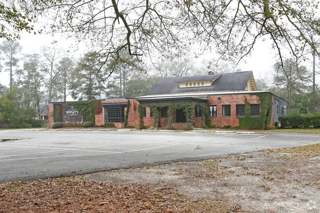
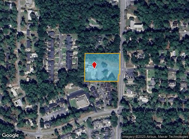
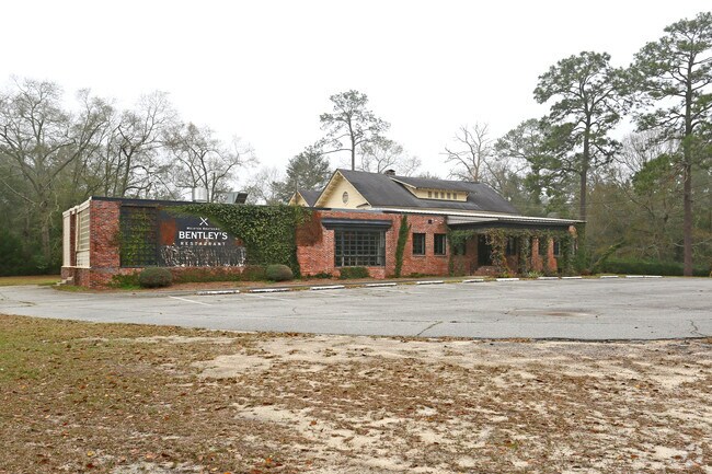
Property Record
1520 S Main St, Moultrie, GA 31768
NEARBY LISTINGS FOR SALE OR LEASE
Property Detail
1520 S Main St
Moultrie, GA
Colonial Heights
M027-051
LOT 12 13 14 BL 2
Restaurantbuilding
Colquitt
X
Georgia
13071C0191E
12
2024
2.76 AC
2024
Albany/Southwest
970800
Other Market Areas
7,297 SF
DEMOGRAPHICS near 1520 S Main St
1 Mile
3 Mile
5 Mile
2024 Total Population
4,733
18,880
26,776
2029 Population
4,747
19,014
26,845
Pop Growth 2024-2029
+ 0.30%
+ 0.71%
+ 0.26%
Average Age
39
39
39
2024 Total Households
1,819
7,332
10,117
HH Growth 2024-2029
+ 0.22%
+ 0.67%
+ 0.26%
Median Household Inc
$39,575
$35,404
$38,433
Avg Household Size
2.50
2.50
2.50
2024 Avg HH Vehicles
2.00
2.00
2.00
Median Home Value
$132,987
$118,093
$124,519
Median Year Built
1965
1976
1980
Nearby Places
Map Layers
Map Styles
 Street
 Aerial
- Restaurants
- Banks
- Shops
- Fitness
- Groceries
PUBLIC TRANSPORTATION
AIRPORT
Southwest Georgia Regional
DRIVE
WALK
Distance
Southwest Georgia Regional
59 min
41.4 mi
Valdosta Regional
DRIVE
WALK
Distance
Valdosta Regional
66 min
45.4 mi
SALE & LEASE HISTORY
LISTING DATE
SALE/LEASE

Oct 23, 2018
For Sale
May 15, 2017
For Sale
Feb 21, 2017
For Sale
Nearby Properties
Address
Land Use
TOTAL SIZE
Lot Size
Zoning
Address
Land Use
TOTAL SIZE
Lot Size
Zoning
11,040 SF
29.97 AC
Address
Land Use
TOTAL SIZE
Lot Size
Zoning
200,104 SF
186.32 AC
Address
Land Use
TOTAL SIZE
Lot Size
Zoning
38,268 SF
2.07 AC
Address
Land Use
TOTAL SIZE
Lot Size
Zoning
24.25 AC
Address
Land Use
TOTAL SIZE
Lot Size
Zoning
21,678 SF
5.75 AC
Address
Land Use
TOTAL SIZE
Lot Size
Zoning
115.93 AC
COMMERCIAL
Address
Land Use
TOTAL SIZE
Lot Size
Zoning
21,866 SF
1.44 AC
Address
Land Use
TOTAL SIZE
Lot Size
Zoning
11.45 AC
Address
Land Use
TOTAL SIZE
Lot Size
Zoning
15.56 AC
Address
Land Use
TOTAL SIZE
Lot Size
Zoning
2,606 SF
15 AC
Address
Land Use
TOTAL SIZE
Lot Size
Zoning
17,574 SF
1.59 AC
Address
Land Use
TOTAL SIZE
Lot Size
Zoning
149,407 SF
15.29 AC
Address
Land Use
TOTAL SIZE
Lot Size
Zoning
27,504 SF
1.98 AC
Address
Land Use
TOTAL SIZE
Lot Size
Zoning
64,000 SF
13.98 AC
Address
Land Use
TOTAL SIZE
Lot Size
Zoning
18,096 SF
12.13 AC
Address
Land Use
TOTAL SIZE
Lot Size
Zoning
111,860 SF
13.50 AC
002
Address
Land Use
TOTAL SIZE
Lot Size
Zoning
105,612 SF
13.19 AC
002
Address
Land Use
TOTAL SIZE
Lot Size
Zoning
40,781 SF
25.47 AC
Address
Land Use
TOTAL SIZE
Lot Size
Zoning
61,200 SF
9.50 AC
Address
Land Use
TOTAL SIZE
Lot Size
Zoning
42,592 SF
9.75 AC
Address
Land Use
TOTAL SIZE
Lot Size
Zoning
189,470 SF
12.68 AC
Address
Land Use
TOTAL SIZE
Lot Size
Zoning
90,694 SF
19.17 AC
Address
Land Use
TOTAL SIZE
Lot Size
Zoning
48,965 SF
5.24 AC
Address
Land Use
TOTAL SIZE
Lot Size
Zoning
27,217 SF
20.32 AC
Address
Land Use
TOTAL SIZE
Lot Size
Zoning
9,916 SF
6.24 AC
002
Address
Land Use
TOTAL SIZE
Lot Size
Zoning
19,702 SF
0.59 AC
Address
Land Use
TOTAL SIZE
Lot Size
Zoning
21,574 SF
1.11 AC
Address
Land Use
TOTAL SIZE
Lot Size
Zoning
64,840 SF
9 AC
Address
Land Use
TOTAL SIZE
Lot Size
Zoning
2,614 SF
8.30 AC
Address
Land Use
TOTAL SIZE
Lot Size
Zoning
37,295 SF
8.30 AC
The World's #1 Commercial Real Estate Marketplace
Connect with us
© 2025 CoStar Group
The information above has been obtained from sources believed reliable. While we do not doubt its accuracy we have not verified it and make no guarantee, warranty or representation about it. It is your responsibility to independently confirm its accuracy and completeness. Any projections, opinions, assumptions, or estimates used are for example only and do not represent the current or future performance of the property. The value of this transaction to you depends on tax and other factors which should be evaluated by your tax, financial, and legal advisors. You and your advisors should conduct a careful, independent investigation of the property to determine to your satisfaction the suitability of the property for your needs.