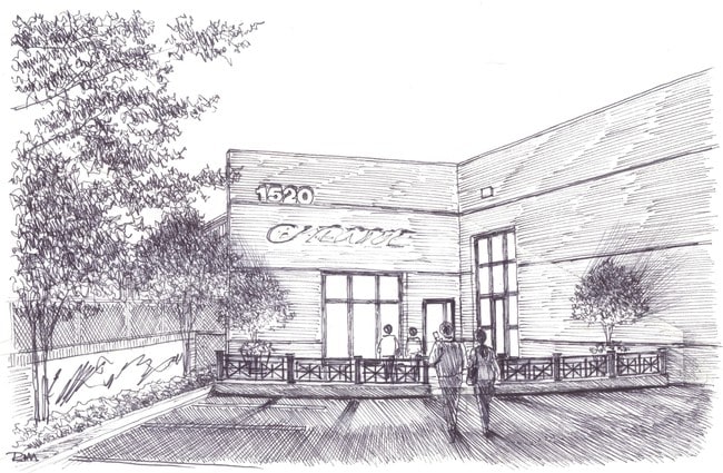
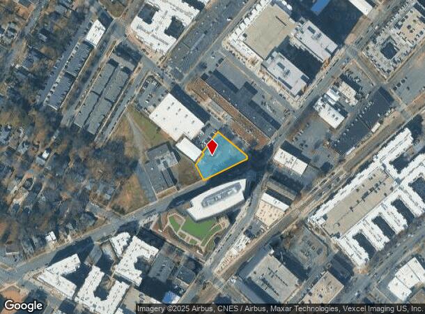
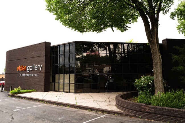
Property Record
1520 S Tryon St, Charlotte, NC 28203
Current Lease Availabilities
NEARBY LISTINGS FOR SALE OR LEASE
Property Detail
1520 S Tryon St
Charlotte-Concord-Gastonia, NC-SC
B
119-088-34
L22-26B7M332-96&ADJ TR&STR
Officebuilding
Mecklenburg
X
North Carolina
3710454300L
34
2024
0.61 AC
2025
I-277/Remount Rd
000402
Charlotte
4,524 SF
DEMOGRAPHICS near 1520 S Tryon St
1 Mile
3 Mile
5 Mile
2024 Total Population
21,478
126,562
255,671
2029 Population
23,116
135,603
273,044
Pop Growth 2024-2029
+ 7.63%
+ 7.14%
+ 6.80%
Average Age
33
36
36
2024 Total Households
13,093
63,715
119,666
HH Growth 2024-2029
+ 7.66%
+ 7.32%
+ 6.99%
Median Household Inc
$96,470
$78,984
$70,589
Avg Household Size
1.60
1.90
2.10
2024 Avg HH Vehicles
1.00
1.00
1.00
Median Home Value
$632,888
$491,593
$419,045
Median Year Built
2010
2000
1991
Nearby Places
- Restaurants
- Banks
- Shops
- Fitness
- Groceries
PUBLIC TRANSPORTATION
TRANSIT/SUBWAY
Bland Street (Charlotte Trolley - Charlotte Area Transit System (CATS), LYNX Blue Line - Charlotte Area Transit System (CATS))
DRIVE
WALK
Distance
Bland Street (Charlotte Trolley - Charlotte Area Transit System (CATS), LYNX Blue Line - Charlotte Area Transit System (CATS))
0 min
4 min
0.1 mi
East/West (Charlotte Trolley - Charlotte Area Transit System (CATS), LYNX Blue Line - Charlotte Area Transit System (CATS))
DRIVE
WALK
Distance
East/West (Charlotte Trolley - Charlotte Area Transit System (CATS), LYNX Blue Line - Charlotte Area Transit System (CATS))
1 min
7 min
0.4 mi
Carson (Charlotte Trolley - Charlotte Area Transit System (CATS), LYNX Blue Line - Charlotte Area Transit System (CATS))
DRIVE
WALK
Distance
Carson (Charlotte Trolley - Charlotte Area Transit System (CATS), LYNX Blue Line - Charlotte Area Transit System (CATS))
2 min
9 min
0.5 mi
Morehead (Charlotte Trolley - Charlotte Area Transit System (CATS))
DRIVE
WALK
Distance
Morehead (Charlotte Trolley - Charlotte Area Transit System (CATS))
2 min
11 min
0.6 mi
Stonewall (Charlotte Trolley - Charlotte Area Transit System (CATS), LYNX Blue Line - Charlotte Area Transit System (CATS))
DRIVE
WALK
Distance
Stonewall (Charlotte Trolley - Charlotte Area Transit System (CATS), LYNX Blue Line - Charlotte Area Transit System (CATS))
2 min
15 min
0.8 mi
COMMUTER RAIL
Charlotte Amtrak Station (Carolinian - Amtrak, Crescent - Amtrak, Piedmont - Amtrak)
DRIVE
WALK
Distance
Charlotte Amtrak Station (Carolinian - Amtrak, Crescent - Amtrak, Piedmont - Amtrak)
5 min
2.7 mi
AIRPORT
Charlotte/Douglas International
DRIVE
WALK
Distance
Charlotte/Douglas International
13 min
6.5 mi
Concord-Padgett Regional
DRIVE
WALK
Distance
Concord-Padgett Regional
26 min
17.9 mi
Freight Ports
North Charleston Terminal
DRIVE
WALK
Distance
North Charleston Terminal
225 min
198.3 mi
Nearby Properties
Address
Land Use
TOTAL SIZE
Lot Size
Zoning
Address
Land Use
TOTAL SIZE
Lot Size
Zoning
3,286,640 SF
55.70 AC
O6CD
Address
Land Use
TOTAL SIZE
Lot Size
Zoning
1,652,470 SF
10.96 AC
UMUD
Address
Land Use
TOTAL SIZE
Lot Size
Zoning
780,000 SF
7.69 AC
UMUD-O
Address
Land Use
TOTAL SIZE
Lot Size
Zoning
1,097,257 SF
2.34 AC
UMUD-O
Address
Land Use
TOTAL SIZE
Lot Size
Zoning
1,498,190 SF
2.09 AC
UMUD
Address
Land Use
TOTAL SIZE
Lot Size
Zoning
955,273 SF
1.83 AC
Address
Land Use
TOTAL SIZE
Lot Size
Zoning
1,483,634 SF
1.49 AC
Address
Land Use
TOTAL SIZE
Lot Size
Zoning
1,250,218 SF
17.75 AC
O2
Address
Land Use
TOTAL SIZE
Lot Size
Zoning
1,097,857 SF
2.40 AC
UMUDO
Address
Land Use
TOTAL SIZE
Lot Size
Zoning
1,052,203 SF
2.17 AC
Address
Land Use
TOTAL SIZE
Lot Size
Zoning
1,752,744 SF
3.20 AC
UMUDO
Address
Land Use
TOTAL SIZE
Lot Size
Zoning
1,266,700 SF
2.98 AC
Address
Land Use
TOTAL SIZE
Lot Size
Zoning
852,355 SF
16.72 AC
MUDDO
Address
Land Use
TOTAL SIZE
Lot Size
Zoning
1,325,933 SF
34.09 AC
Address
Land Use
TOTAL SIZE
Lot Size
Zoning
925,808 SF
1.84 AC
UMUD-O
Address
Land Use
TOTAL SIZE
Lot Size
Zoning
1,435,616 SF
33.78 AC
UMUD
Address
Land Use
TOTAL SIZE
Lot Size
Zoning
1,250,926 SF
4.89 AC
I2
Address
Land Use
TOTAL SIZE
Lot Size
Zoning
582,357 SF
1.13 AC
MUDD-O
Address
Land Use
TOTAL SIZE
Lot Size
Zoning
1,053,936 SF
2.47 AC
UMUD
Address
Land Use
TOTAL SIZE
Lot Size
Zoning
865,160 SF
2.80 AC
UMUD
Address
Land Use
TOTAL SIZE
Lot Size
Zoning
839,976 SF
1.62 AC
UMUD
Address
Land Use
TOTAL SIZE
Lot Size
Zoning
1,017,564 SF
13.91 AC
O2
Address
Land Use
TOTAL SIZE
Lot Size
Zoning
894,108 SF
4.52 AC
UMUDO
Address
Land Use
TOTAL SIZE
Lot Size
Zoning
696,527 SF
1.96 AC
UMUDO
Address
Land Use
TOTAL SIZE
Lot Size
Zoning
1,025,674 SF
3.43 AC
UMUD
Address
Land Use
TOTAL SIZE
Lot Size
Zoning
916,725 SF
2.35 AC
UMUD
Address
Land Use
TOTAL SIZE
Lot Size
Zoning
626,053 SF
2.77 AC
I2
Address
Land Use
TOTAL SIZE
Lot Size
Zoning
944,863 SF
3.58 AC
UMUD
Address
Land Use
TOTAL SIZE
Lot Size
Zoning
416,225 SF
0.64 AC
Address
Land Use
TOTAL SIZE
Lot Size
Zoning
1,039,198 SF
5.62 AC
UMUD
The World's #1 Commercial Real Estate Marketplace
Connect with us
© 2025 CoStar Group
The information above has been obtained from sources believed reliable. While we do not doubt its accuracy we have not verified it and make no guarantee, warranty or representation about it. It is your responsibility to independently confirm its accuracy and completeness. Any projections, opinions, assumptions, or estimates used are for example only and do not represent the current or future performance of the property. The value of this transaction to you depends on tax and other factors which should be evaluated by your tax, financial, and legal advisors. You and your advisors should conduct a careful, independent investigation of the property to determine to your satisfaction the suitability of the property for your needs.