Property Record
1520 W Us Highway 34, Loveland, CO 80537
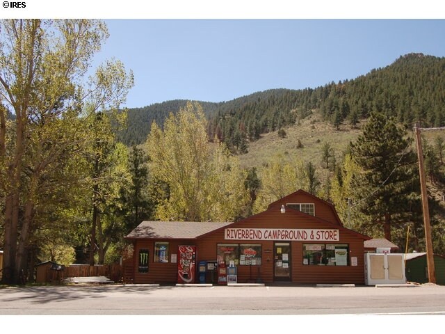
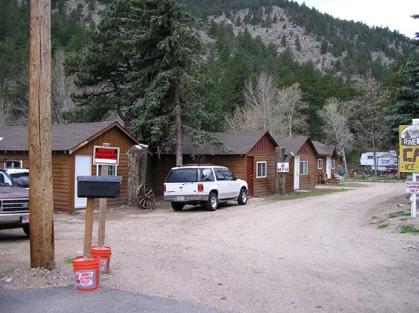

Property Detail
1520 W Us Highway 34
Fort Collins-Loveland, CO
MH SERIAL: K5423A YEAR: 1960 MAKE: AMERICAN
15022-07-016
Larimer
Mobilehomepark
Colorado
2024
1.34 AC
2025
Outlying Larimer County
001904
Denver
5,332 SF
NEARBY LISTINGS FOR SALE OR LEASE
-
-
View all Loveland listings for sale on LoopNet.com
DEMOGRAPHICS near 1520 W Us Highway 34
1 mile
3 mile
5 mile
2025 Total Population
143
315
782
2030 Population
139
310
779
Pop Growth 2025-2030
(2.80%)
(1.59%)
(0.38%)
Average Age
49
50
51
2025 Total Households
65
143
355
HH Growth 2025-2030
(3.08%)
(1.40%)
(0.28%)
Median Household Inc
$99,999
$87,500
$94,270
Avg Household Size
2.10
2.10
2.10
2025 Avg HH Vehicles
3.00
3.00
2.00
Median Home Value
$798,076
$754,385
$755,244
Median Year Built
1994
1993
1992
Nearby Places
Map Layers
Map Styles
 Street
 Aerial
Transit
 Traffic
 Biking
Places
Listings with unknown addresses are not visible on the map
- Restaurants
- Banks
- Shops
- Fitness
- Groceries
SALE & LEASE HISTORY
LISTING DATE
SALE/LEASE

Jan 27, 2018
For Sale
Nearby Properties
Address
Land Use
TOTAL SIZE
Lot Size
Zoning
Address
Land Use
TOTAL SIZE
Lot Size
Zoning
8,796 SF
22.61 AC
O
Address
Land Use
TOTAL SIZE
Lot Size
Zoning
1,548 SF
324.37 AC
O
Address
Land Use
TOTAL SIZE
Lot Size
Zoning
2,208 SF
9.11 AC
O
Address
Land Use
TOTAL SIZE
Lot Size
Zoning
4,504 SF
0.10 AC
O
Address
Land Use
TOTAL SIZE
Lot Size
Zoning
11,140 SF
35.91 AC
O
Address
Land Use
TOTAL SIZE
Lot Size
Zoning
3,180 SF
1.29 AC
O
Address
Land Use
TOTAL SIZE
Lot Size
Zoning
12,529 SF
200.79 AC
O
Address
Land Use
TOTAL SIZE
Lot Size
Zoning
10,634 SF
393.32 AC
O
Address
Land Use
TOTAL SIZE
Lot Size
Zoning
519.45 AC
O
Address
Land Use
TOTAL SIZE
Lot Size
Zoning
10,452 SF
35.15 AC
Address
Land Use
TOTAL SIZE
Lot Size
Zoning
35 AC
O
Address
Land Use
TOTAL SIZE
Lot Size
Zoning
2,224 SF
0.71 AC
O
Address
Land Use
TOTAL SIZE
Lot Size
Zoning
2,400 SF
0.54 AC
Address
Land Use
TOTAL SIZE
Lot Size
Zoning
6,584 SF
50.27 AC
O
Address
Land Use
TOTAL SIZE
Lot Size
Zoning
5,641 SF
37.50 AC
O
Address
Land Use
TOTAL SIZE
Lot Size
Zoning
2,336 SF
35 AC
O
Address
Land Use
TOTAL SIZE
Lot Size
Zoning
3,600 SF
35.74 AC
O
Address
Land Use
TOTAL SIZE
Lot Size
Zoning
434 SF
1.10 AC
O
Address
Land Use
TOTAL SIZE
Lot Size
Zoning
2,128 SF
456.68 AC
O
Address
Land Use
TOTAL SIZE
Lot Size
Zoning
1,200 SF
0.38 AC
O
Address
Land Use
TOTAL SIZE
Lot Size
Zoning
9.82 AC
E
Address
Land Use
TOTAL SIZE
Lot Size
Zoning
736 SF
23.22 AC
E
Address
Land Use
TOTAL SIZE
Lot Size
Zoning
4.91 AC
E
Address
Land Use
TOTAL SIZE
Lot Size
Zoning
10.23 AC
E
Address
Land Use
TOTAL SIZE
Lot Size
Zoning
6.34 AC
E
Address
Land Use
TOTAL SIZE
Lot Size
Zoning
20.03 AC
E
Address
Land Use
TOTAL SIZE
Lot Size
Zoning
5 AC
O
Address
Land Use
TOTAL SIZE
Lot Size
Zoning
1.26 AC
O
Address
Land Use
TOTAL SIZE
Lot Size
Zoning
1.88 AC
O
The World's #1 Commercial Real Estate Marketplace
Connect with us
© 2026 CoStar Group
The information above has been obtained from sources believed reliable. While we do not doubt its accuracy we have not verified it and make no guarantee, warranty or representation about it. It is your responsibility to independently confirm its accuracy and completeness. Any projections, opinions, assumptions, or estimates used are for example only and do not represent the current or future performance of the property. The value of this transaction to you depends on tax and other factors which should be evaluated by your tax, financial, and legal advisors. You and your advisors should conduct a careful, independent investigation of the property to determine to your satisfaction the suitability of the property for your needs.