Property Record
15200 Highway 41 N, Evansville, IN 47725
NEARBY LISTINGS FOR SALE OR LEASE
-
-
View all Evansville listings for lease on LoopNet.com
Property Detail
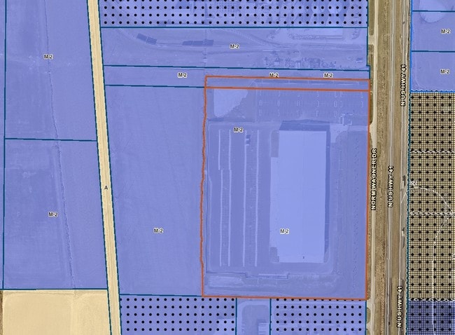
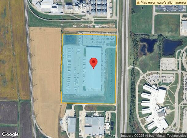
15200 Highway 41 N
82-04-05-009-060.025-030
Vectren Utility Holdings Parce
Warehouse
PT NW 5-5-10 (CONJOINED PARCEL 1 OF 2)
X
Vanderburgh
18163C0106D
Indiana
2024
41.82 AC
2024
Northside/Airport
010702
Evansville
253,580 SF
Evansville, IN-KY
DEMOGRAPHICS near 15200 Highway 41 N
1 Mile
3 Mile
5 Mile
2024 Total Population
1,027
7,218
23,342
2029 Population
1,032
7,175
23,071
Pop Growth 2024-2029
+ 0.49%
(0.60%)
(1.16%)
Average Age
41
43
41
2024 Total Households
370
2,694
8,694
HH Growth 2024-2029
+ 0.54%
(0.63%)
(1.23%)
Median Household Inc
$92,429
$98,373
$96,635
Avg Household Size
2.70
2.60
2.60
2024 Avg HH Vehicles
2.00
2.00
2.00
Median Home Value
$271,935
$282,231
$245,463
Median Year Built
2003
1994
1995
Nearby Places
Map Layers
Map Styles
 Street
 Aerial
- Restaurants
- Banks
- Shops
- Fitness
- Groceries
PUBLIC TRANSPORTATION
AIRPORT
Evansville Regional
DRIVE
WALK
Distance
Evansville Regional
14 min
7.4 mi
Freight Ports
Port of Toledo
DRIVE
WALK
Distance
Port of Toledo
449 min
384.5 mi
SALE & LEASE HISTORY
LISTING DATE
SALE/LEASE

Sep 26, 2016
For Lease
Nearby Properties
Address
Land Use
TOTAL SIZE
Lot Size
Zoning
Address
Land Use
TOTAL SIZE
Lot Size
Zoning
1,785 SF
70.87 AC
5
Address
Land Use
TOTAL SIZE
Lot Size
Zoning
990 SF
48.21 AC
Address
Land Use
TOTAL SIZE
Lot Size
Zoning
73,423 SF
9.97 AC
Address
Land Use
TOTAL SIZE
Lot Size
Zoning
55,870 SF
6.30 AC
Address
Land Use
TOTAL SIZE
Lot Size
Zoning
31,669 SF
8.55 AC
Address
Land Use
TOTAL SIZE
Lot Size
Zoning
9,250 SF
8.57 AC
Address
Land Use
TOTAL SIZE
Lot Size
Zoning
46,876 SF
12.78 AC
Address
Land Use
TOTAL SIZE
Lot Size
Zoning
50,751 SF
7.04 AC
4
Address
Land Use
TOTAL SIZE
Lot Size
Zoning
143,507 SF
27.98 AC
55
Address
Land Use
TOTAL SIZE
Lot Size
Zoning
18,117 SF
12.41 AC
Address
Land Use
TOTAL SIZE
Lot Size
Zoning
8,740 SF
5.97 AC
4
Address
Land Use
TOTAL SIZE
Lot Size
Zoning
37,203 SF
7.85 AC
4
Address
Land Use
TOTAL SIZE
Lot Size
Zoning
22,964 SF
15.73 AC
Address
Land Use
TOTAL SIZE
Lot Size
Zoning
3,591 SF
1.62 AC
Address
Land Use
TOTAL SIZE
Lot Size
Zoning
40,713 SF
16.45 AC
Address
Land Use
TOTAL SIZE
Lot Size
Zoning
49,160 SF
12.42 AC
4
Address
Land Use
TOTAL SIZE
Lot Size
Zoning
13,334 SF
1.69 AC
1
Address
Land Use
TOTAL SIZE
Lot Size
Zoning
15,210 SF
7.22 AC
Address
Land Use
TOTAL SIZE
Lot Size
Zoning
26,000 SF
8.29 AC
Address
Land Use
TOTAL SIZE
Lot Size
Zoning
37,928 SF
6.67 AC
4
Address
Land Use
TOTAL SIZE
Lot Size
Zoning
5,626 SF
1.91 AC
Address
Land Use
TOTAL SIZE
Lot Size
Zoning
45,000 SF
3.87 AC
5
Address
Land Use
TOTAL SIZE
Lot Size
Zoning
3,443 SF
1.45 AC
Address
Land Use
TOTAL SIZE
Lot Size
Zoning
3,581 SF
1.22 AC
Address
Land Use
TOTAL SIZE
Lot Size
Zoning
3,659 SF
1.05 AC
4
Address
Land Use
TOTAL SIZE
Lot Size
Zoning
8,021 SF
5.49 AC
4
Address
Land Use
TOTAL SIZE
Lot Size
Zoning
6,498 SF
171.84 AC
Address
Land Use
TOTAL SIZE
Lot Size
Zoning
12,554 SF
1.55 AC
1
Address
Land Use
TOTAL SIZE
Lot Size
Zoning
14,274 SF
2.10 AC
4
The World's #1 Commercial Real Estate Marketplace
Connect with us
© 2025 CoStar Group
The information above has been obtained from sources believed reliable. While we do not doubt its accuracy we have not verified it and make no guarantee, warranty or representation about it. It is your responsibility to independently confirm its accuracy and completeness. Any projections, opinions, assumptions, or estimates used are for example only and do not represent the current or future performance of the property. The value of this transaction to you depends on tax and other factors which should be evaluated by your tax, financial, and legal advisors. You and your advisors should conduct a careful, independent investigation of the property to determine to your satisfaction the suitability of the property for your needs.