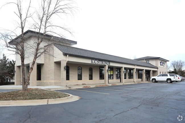
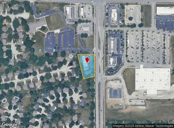
Property Record
15200 S Blackbob Rd, Olathe, KS 66062

NEARBY LISTINGS FOR SALE OR LEASE
Property Detail
15200 S Blackbob Rd
Kansas City, MO-KS
Blackbob Meadows Shops Third
DP04420000-0001
BLACKBOB MEADOWS SHOPS THIRD PLAT LT 1 OLC 679 5 1
Animalhospitalvet
Johnson
X
Kansas
20091C0095G
1
2024
0.85 AC
2024
South Johnson County
053510
Kansas City
7,095 SF
DEMOGRAPHICS near 15200 S Blackbob Rd
1 Mile
3 Mile
5 Mile
2024 Total Population
13,367
81,627
178,459
2029 Population
13,751
85,138
185,994
Pop Growth 2024-2029
+ 2.87%
+ 4.30%
+ 4.22%
Average Age
36
37
38
2024 Total Households
4,336
27,998
63,724
HH Growth 2024-2029
+ 2.98%
+ 4.36%
+ 4.30%
Median Household Inc
$125,459
$115,468
$105,969
Avg Household Size
3.00
2.80
2.70
2024 Avg HH Vehicles
2.00
2.00
2.00
Median Home Value
$286,899
$334,521
$343,915
Median Year Built
1993
1996
1994
Nearby Places
Map Layers
Map Styles
 Street
 Aerial
- Restaurants
- Banks
- Shops
- Fitness
- Groceries
PUBLIC TRANSPORTATION
AIRPORT
Kansas City International
DRIVE
WALK
Distance
Kansas City International
53 min
39.5 mi
Nearby Properties
Address
Land Use
TOTAL SIZE
Lot Size
Zoning
Address
Land Use
TOTAL SIZE
Lot Size
Zoning
482,713 SF
77.78 AC
AG
Address
Land Use
TOTAL SIZE
Lot Size
Zoning
512,643 SF
75.55 AC
AG
Address
Land Use
TOTAL SIZE
Lot Size
Zoning
211,054 SF
77.48 AC
R-1
Address
Land Use
TOTAL SIZE
Lot Size
Zoning
40,647 SF
7.40 AC
R-4
Address
Land Use
TOTAL SIZE
Lot Size
Zoning
103,102 SF
31.90 AC
R-1
Address
Land Use
TOTAL SIZE
Lot Size
Zoning
129,325 SF
4.50 AC
R-1
Address
Land Use
TOTAL SIZE
Lot Size
Zoning
137,955 SF
23.80 AC
R-1
Address
Land Use
TOTAL SIZE
Lot Size
Zoning
137,122 SF
7.68 AC
C-1
Address
Land Use
TOTAL SIZE
Lot Size
Zoning
146,832 SF
30 AC
R-1
Address
Land Use
TOTAL SIZE
Lot Size
Zoning
150,122 SF
17.48 AC
R-1
Address
Land Use
TOTAL SIZE
Lot Size
Zoning
934,106 SF
34.09 AC
BP
Address
Land Use
TOTAL SIZE
Lot Size
Zoning
157,344 SF
12.69 AC
R-1
Address
Land Use
TOTAL SIZE
Lot Size
Zoning
61,479 SF
8.14 AC
C-2
Address
Land Use
TOTAL SIZE
Lot Size
Zoning
130,605 SF
18.01 AC
R-1
Address
Land Use
TOTAL SIZE
Lot Size
Zoning
32,992 SF
3.85 AC
R-4
Address
Land Use
TOTAL SIZE
Lot Size
Zoning
86,095 SF
16.95 AC
R-1
Address
Land Use
TOTAL SIZE
Lot Size
Zoning
71,221 SF
17.13 AC
R-1
Address
Land Use
TOTAL SIZE
Lot Size
Zoning
9,424 SF
5.15 AC
R-4
Address
Land Use
TOTAL SIZE
Lot Size
Zoning
117,084 SF
10.69 AC
R-1
Address
Land Use
TOTAL SIZE
Lot Size
Zoning
71,221 SF
13.84 AC
R-1
Address
Land Use
TOTAL SIZE
Lot Size
Zoning
52,863 SF
10.81 AC
R-1A
Address
Land Use
TOTAL SIZE
Lot Size
Zoning
81,753 SF
20.88 AC
R-1
Address
Land Use
TOTAL SIZE
Lot Size
Zoning
73,159 SF
12.54 AC
R-1
Address
Land Use
TOTAL SIZE
Lot Size
Zoning
81,096 SF
121.93 AC
AG
Address
Land Use
TOTAL SIZE
Lot Size
Zoning
72,091 SF
11.33 AC
R-1
Address
Land Use
TOTAL SIZE
Lot Size
Zoning
92,328 SF
9.49 AC
M-1
Address
Land Use
TOTAL SIZE
Lot Size
Zoning
69,723 SF
11.29 AC
R-1
Address
Land Use
TOTAL SIZE
Lot Size
Zoning
62,832 SF
15.43 AC
CTY RUR
Address
Land Use
TOTAL SIZE
Lot Size
Zoning
72,324 SF
8.84 AC
R-1
Address
Land Use
TOTAL SIZE
Lot Size
Zoning
65,691 SF
11.51 AC
RP-1
The World's #1 Commercial Real Estate Marketplace
Connect with us
© 2025 CoStar Group
The information above has been obtained from sources believed reliable. While we do not doubt its accuracy we have not verified it and make no guarantee, warranty or representation about it. It is your responsibility to independently confirm its accuracy and completeness. Any projections, opinions, assumptions, or estimates used are for example only and do not represent the current or future performance of the property. The value of this transaction to you depends on tax and other factors which should be evaluated by your tax, financial, and legal advisors. You and your advisors should conduct a careful, independent investigation of the property to determine to your satisfaction the suitability of the property for your needs.