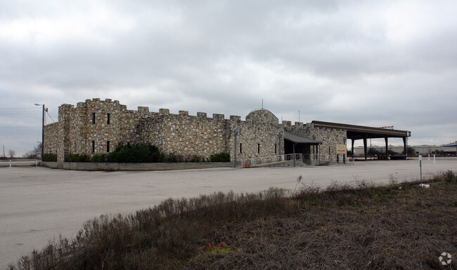
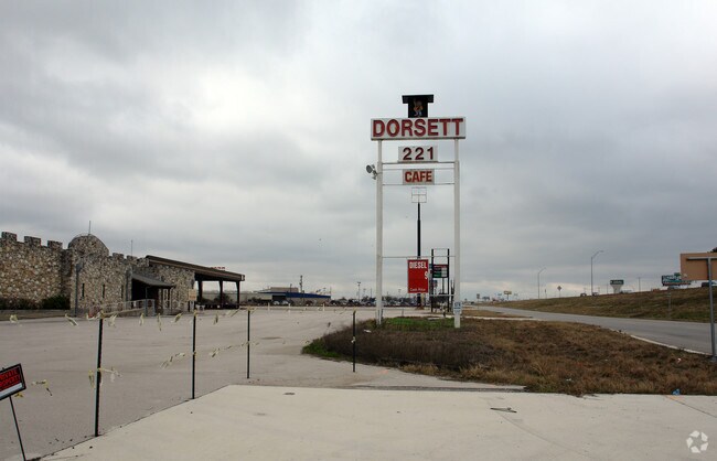
Property Record
15201 Interstate 35, Buda, TX 78610


Property Detail
15201 Interstate 35
Austin-Round Rock-San Marcos, TX
DORSETT INDUSTRIAL SUBD NO. 2, LOT 7, ACRES 12.775
R93330
Hays
Commercialnec
Texas
B and X Area of moderate flood hazard, usually the area between the limits of the 100-year and 500-year floods.
7
2024
12.78 AC
2025
Hays County
010923
Austin
11,636 SF
NEARBY LISTINGS FOR SALE OR LEASE
DEMOGRAPHICS near 15201 Interstate 35
1 mile
3 mile
5 mile
2024 Total Population
7,319
41,829
101,245
2029 Population
8,632
48,584
114,535
Pop Growth 2024-2029
+ 17.94%
+ 16.15%
+ 13.13%
Average Age
35
36
37
2024 Total Households
2,910
15,067
37,042
HH Growth 2024-2029
+ 18.87%
+ 17.08%
+ 13.59%
Median Household Inc
$107,357
$105,045
$102,383
Avg Household Size
2.50
2.80
2.70
2024 Avg HH Vehicles
2.00
2.00
2.00
Median Home Value
$432,954
$418,950
$426,426
Median Year Built
2011
2011
2010
Nearby Places
Map Layers
Map Styles
 Street
 Aerial
Transit
 Traffic
 Biking
Places
Listings with unknown addresses are not visible on the map
- Restaurants
- Banks
- Shops
- Fitness
- Groceries
PUBLIC TRANSPORTATION
AIRPORT
Austin-Bergstrom International
Drive
Walk
Distance
Austin-Bergstrom International
28 min
19.2 mi
Nearby Properties
Address
Land Use
TOTAL SIZE
Lot Size
Zoning
Address
Land Use
TOTAL SIZE
Lot Size
Zoning
281,107 SF
15.91 AC
Address
Land Use
TOTAL SIZE
Lot Size
Zoning
288,750 SF
14.86 AC
Address
Land Use
TOTAL SIZE
Lot Size
Zoning
263,100 SF
15.97 AC
Address
Land Use
TOTAL SIZE
Lot Size
Zoning
262,350 SF
15.30 AC
Address
Land Use
TOTAL SIZE
Lot Size
Zoning
414,780 SF
15.89 AC
Address
Land Use
TOTAL SIZE
Lot Size
Zoning
305,661 SF
31.74 AC
Address
Land Use
TOTAL SIZE
Lot Size
Zoning
249,155 SF
17.60 AC
Address
Land Use
TOTAL SIZE
Lot Size
Zoning
7,175 SF
15.09 AC
Address
Land Use
TOTAL SIZE
Lot Size
Zoning
273,464 SF
16.14 AC
Address
Land Use
TOTAL SIZE
Lot Size
Zoning
161,083 SF
15 AC
Address
Land Use
TOTAL SIZE
Lot Size
Zoning
310,992 SF
16.75 AC
Address
Land Use
TOTAL SIZE
Lot Size
Zoning
437,903 SF
10.76 AC
Address
Land Use
TOTAL SIZE
Lot Size
Zoning
272,058 SF
12.39 AC
Address
Land Use
TOTAL SIZE
Lot Size
Zoning
347,316 SF
14 AC
Address
Land Use
TOTAL SIZE
Lot Size
Zoning
398,000 SF
23.28 AC
Address
Land Use
TOTAL SIZE
Lot Size
Zoning
181,660 SF
12.35 AC
Address
Land Use
TOTAL SIZE
Lot Size
Zoning
190,462 SF
9.67 AC
Address
Land Use
TOTAL SIZE
Lot Size
Zoning
78,782 SF
19.60 AC
Address
Land Use
TOTAL SIZE
Lot Size
Zoning
87,111 SF
12.40 AC
Address
Land Use
TOTAL SIZE
Lot Size
Zoning
63,158 SF
10 AC
Address
Land Use
TOTAL SIZE
Lot Size
Zoning
229,187 SF
14.78 AC
Address
Land Use
TOTAL SIZE
Lot Size
Zoning
310,250 SF
23.90 AC
Address
Land Use
TOTAL SIZE
Lot Size
Zoning
239,400 SF
17.80 AC
Address
Land Use
TOTAL SIZE
Lot Size
Zoning
290,000 SF
40.17 AC
Address
Land Use
TOTAL SIZE
Lot Size
Zoning
238,300 SF
11.60 AC
Address
Land Use
TOTAL SIZE
Lot Size
Zoning
67,231 SF
2.51 AC
Address
Land Use
TOTAL SIZE
Lot Size
Zoning
137,007 SF
7.24 AC
Address
Land Use
TOTAL SIZE
Lot Size
Zoning
231,734 SF
19.71 AC
Address
Land Use
TOTAL SIZE
Lot Size
Zoning
49,096 SF
22.99 AC
Address
Land Use
TOTAL SIZE
Lot Size
Zoning
121,976 SF
23.17 AC
The World's #1 Commercial Real Estate Marketplace
Connect with us
© 2026 CoStar Group
The information above has been obtained from sources believed reliable. While we do not doubt its accuracy we have not verified it and make no guarantee, warranty or representation about it. It is your responsibility to independently confirm its accuracy and completeness. Any projections, opinions, assumptions, or estimates used are for example only and do not represent the current or future performance of the property. The value of this transaction to you depends on tax and other factors which should be evaluated by your tax, financial, and legal advisors. You and your advisors should conduct a careful, independent investigation of the property to determine to your satisfaction the suitability of the property for your needs.