Property Record
15205 Garnet Trl, Bradenton, FL 34211

Save to a Folder
{{folder.Name}}
{{folder.ListingIds.length}} Properties
{{folder.ListingIds.length}} Property
Create a New Folder
Property Detail
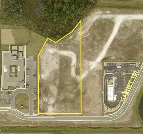
15205 Garnet Trl
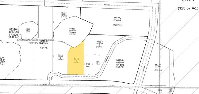
5822-0305-9
LOT 1G, GARNET PLACE PI #5822.0305/9
Medicalbuilding
MANATEE
PD-MU
Florida
B and X Area of moderate flood hazard, usually the area between the limits of the 100-year and 500-year floods.
1g
0
1.17 AC
2026
Manatee Outlying
002020
Tampa/St Petersburg
25,868 SF
North Port-Bradenton-Sarasota, FL
NEARBY LISTINGS FOR SALE OR LEASE
DEMOGRAPHICS near 15205 Garnet Trl
1 mile
3 mile
5 mile
2025 Total Population
4,309
33,067
70,725
2030 Population
4,823
37,697
80,247
Pop Growth 2025-2030
+ 11.93%
+ 14.00%
+ 13.46%
Average Age
42
48
48
2025 Total Households
1,585
13,957
29,310
HH Growth 2025-2030
+ 12.62%
+ 14.29%
+ 13.65%
Median Household Inc
$138,851
$126,753
$128,927
Avg Household Size
2.70
2.30
2.40
2025 Avg HH Vehicles
2.00
2.00
2.00
Median Home Value
$607,870
$712,412
$686,707
Median Year Built
2010
2011
2010
Nearby Places
Map Layers
Map Styles
 Street
 Aerial
Layers
 Traffic
 Biking
Places
Listings with unknown addresses are not visible on the map
- Restaurants
- Banks
- Shops
- Fitness
- Groceries
PUBLIC TRANSPORTATION
AIRPORT
Sarasota/Bradenton International
Drive
Walk
Distance
Sarasota/Bradenton International
27 min
15.6 mi
Freight Ports
Port Manatee
Drive
Walk
Distance
Port Manatee
32 min
21.5 mi
Nearby Properties
Address
Land Use
TOTAL SIZE
Lot Size
Zoning
Address
Land Use
TOTAL SIZE
Lot Size
Zoning
602,710 SF
36.57 AC
PD-MU
Address
Land Use
TOTAL SIZE
Lot Size
Zoning
512,380 SF
11.24 AC
PD-MU
Address
Land Use
TOTAL SIZE
Lot Size
Zoning
337,242 SF
28.33 AC
A GENERAL
Address
Land Use
TOTAL SIZE
Lot Size
Zoning
409,825 SF
23.98 AC
PD-MU
Address
Land Use
TOTAL SIZE
Lot Size
Zoning
349,151 SF
16.70 AC
PD-MU
Address
Land Use
TOTAL SIZE
Lot Size
Zoning
405,307 SF
23.79 AC
PD-MU
Address
Land Use
TOTAL SIZE
Lot Size
Zoning
422,013 SF
11 AC
PD-MU
Address
Land Use
TOTAL SIZE
Lot Size
Zoning
235,732 SF
49.34 AC
PD-PI
Address
Land Use
TOTAL SIZE
Lot Size
Zoning
237,336 SF
9.89 AC
Address
Land Use
TOTAL SIZE
Lot Size
Zoning
210,061 SF
45.14 AC
A-1 SUBURB
Address
Land Use
TOTAL SIZE
Lot Size
Zoning
112,961 SF
19.44 AC
Address
Land Use
TOTAL SIZE
Lot Size
Zoning
158,863 SF
71.98 AC
A GENERAL
Address
Land Use
TOTAL SIZE
Lot Size
Zoning
345,812 SF
37 AC
PD-R
Address
Land Use
TOTAL SIZE
Lot Size
Zoning
180,574 SF
22 AC
A GENERAL
Address
Land Use
TOTAL SIZE
Lot Size
Zoning
77,429 SF
33.55 AC
PD-MU
Address
Land Use
TOTAL SIZE
Lot Size
Zoning
109,010 SF
7 AC
PD-MU
Address
Land Use
TOTAL SIZE
Lot Size
Zoning
125,678 SF
48.86 AC
Address
Land Use
TOTAL SIZE
Lot Size
Zoning
52,492 SF
20.68 AC
A GENERAL
Address
Land Use
TOTAL SIZE
Lot Size
Zoning
139,763 SF
6.66 AC
PD-MU
Address
Land Use
TOTAL SIZE
Lot Size
Zoning
82,573 SF
16.26 AC
PD-C
Address
Land Use
TOTAL SIZE
Lot Size
Zoning
51,432 SF
234.20 AC
Address
Land Use
TOTAL SIZE
Lot Size
Zoning
44,216 SF
74.28 AC
A,PD-R
Address
Land Use
TOTAL SIZE
Lot Size
Zoning
79,283 SF
15.34 AC
Address
Land Use
TOTAL SIZE
Lot Size
Zoning
Address
Land Use
TOTAL SIZE
Lot Size
Zoning
76,672 SF
15.39 AC
PD-C
Address
Land Use
TOTAL SIZE
Lot Size
Zoning
47,803 SF
5 AC
PD-MU
Address
Land Use
TOTAL SIZE
Lot Size
Zoning
58,785 SF
5.49 AC
PD-MU
Address
Land Use
TOTAL SIZE
Lot Size
Zoning
39,742 SF
8.98 AC
A GENERAL
Address
Land Use
TOTAL SIZE
Lot Size
Zoning
73,894 SF
14.99 AC
A GENERAL
Address
Land Use
TOTAL SIZE
Lot Size
Zoning
13,227 SF
124.39 AC
A GENERAL
The World's #1 Commercial Real Estate Marketplace
Connect with us
© 2026 CoStar Group
The information above has been obtained from sources believed reliable. While we do not doubt its accuracy we have not verified it and make no guarantee, warranty or representation about it. It is your responsibility to independently confirm its accuracy and completeness. Any projections, opinions, assumptions, or estimates used are for example only and do not represent the current or future performance of the property. The value of this transaction to you depends on tax and other factors which should be evaluated by your tax, financial, and legal advisors. You and your advisors should conduct a careful, independent investigation of the property to determine to your satisfaction the suitability of the property for your needs.