Property Record
1521 S 4Th St, Louisville, KY 40208
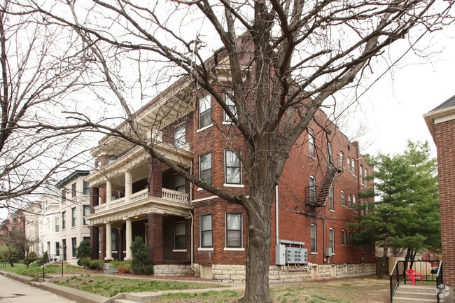
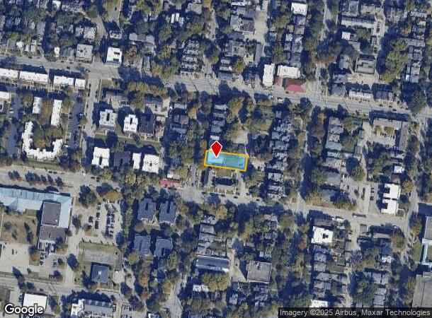

This Property Is For Sale
NEARBY LISTINGS FOR SALE OR LEASE
Property Detail
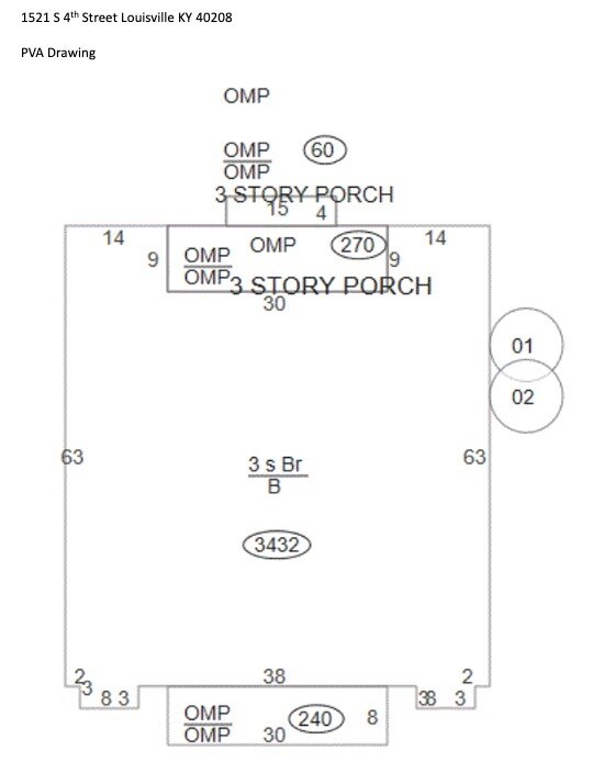
1521 S 4Th St
033C01130000
65 X 180 1521 S 4TH ST 240 FT S HILL ST
Apartment
Jefferson
X
Kentucky
21111C0041F
0.27 AC
2024
Old Louisville
2024
Louisville
005200
Louisville-Jefferson County, KY-IN
10,296 SF
DEMOGRAPHICS near 1521 S 4Th St
1 Mile
3 Mile
5 Mile
2024 Total Population
19,937
128,320
260,917
2029 Population
19,657
128,137
260,744
Pop Growth 2024-2029
(1.40%)
(0.14%)
(0.07%)
Average Age
34
38
39
2024 Total Households
9,244
57,329
114,807
HH Growth 2024-2029
(0.96%)
(0.10%)
(0.03%)
Median Household Inc
$28,978
$38,119
$43,105
Avg Household Size
1.70
2.00
2.10
2024 Avg HH Vehicles
1.00
1.00
1.00
Median Home Value
$212,050
$153,662
$166,202
Median Year Built
1947
1948
1951
Nearby Places
- Restaurants
- Banks
- Shops
- Fitness
- Groceries
PUBLIC TRANSPORTATION
AIRPORT
Louisville Muhammad Ali International
DRIVE
WALK
Distance
Louisville Muhammad Ali International
11 min
4.8 mi
Freight Ports
Port of Toledo
DRIVE
WALK
Distance
Port of Toledo
356 min
307.4 mi
Nearby Properties
Address
Land Use
TOTAL SIZE
Lot Size
Zoning
Address
Land Use
TOTAL SIZE
Lot Size
Zoning
4.80 AC
M3-INDUSTR
Address
Land Use
TOTAL SIZE
Lot Size
Zoning
Address
Land Use
TOTAL SIZE
Lot Size
Zoning
42,228 SF
144.63 AC
R5-RESIDEN
Address
Land Use
TOTAL SIZE
Lot Size
Zoning
5.40 AC
Address
Land Use
TOTAL SIZE
Lot Size
Zoning
572,868 SF
1.57 AC
Address
Land Use
TOTAL SIZE
Lot Size
Zoning
130,724 SF
2.17 AC
Address
Land Use
TOTAL SIZE
Lot Size
Zoning
826,303 SF
2.90 AC
C3-CENTRAL
Address
Land Use
TOTAL SIZE
Lot Size
Zoning
106,330 SF
9.44 AC
M3-INDUSTR
Address
Land Use
TOTAL SIZE
Lot Size
Zoning
211,050 SF
Address
Land Use
TOTAL SIZE
Lot Size
Zoning
4,337 SF
3.71 AC
(C2)COMMER
Address
Land Use
TOTAL SIZE
Lot Size
Zoning
0.56 AC
(C3)CENTRA
Address
Land Use
TOTAL SIZE
Lot Size
Zoning
1,584 SF
4.71 AC
R7-RESIDEN
Address
Land Use
TOTAL SIZE
Lot Size
Zoning
23.42 AC
(W
Address
Land Use
TOTAL SIZE
Lot Size
Zoning
20,449 SF
0.55 AC
C3-CENTRAL
Address
Land Use
TOTAL SIZE
Lot Size
Zoning
21,767 SF
1.47 AC
EZ1-ENTERP
Address
Land Use
TOTAL SIZE
Lot Size
Zoning
59,648 SF
1.66 AC
OR3-OFFICE
Address
Land Use
TOTAL SIZE
Lot Size
Zoning
2.97 AC
C3-CENTRAL
Address
Land Use
TOTAL SIZE
Lot Size
Zoning
Address
Land Use
TOTAL SIZE
Lot Size
Zoning
17,444 SF
1.47 AC
C2-COMMERC
Address
Land Use
TOTAL SIZE
Lot Size
Zoning
12.69 AC
Address
Land Use
TOTAL SIZE
Lot Size
Zoning
549,563 SF
26.13 AC
OTF-OFFICE
Address
Land Use
TOTAL SIZE
Lot Size
Zoning
304,295 SF
0.60 AC
C3-CENTRAL
Address
Land Use
TOTAL SIZE
Lot Size
Zoning
50,946 SF
2.66 AC
(CM)COMMER
Address
Land Use
TOTAL SIZE
Lot Size
Zoning
34,067 SF
0.84 AC
C3-CENTRAL
Address
Land Use
TOTAL SIZE
Lot Size
Zoning
17,916 SF
21.76 AC
EZ1-ENTERP
Address
Land Use
TOTAL SIZE
Lot Size
Zoning
398,435 SF
9.93 AC
Address
Land Use
TOTAL SIZE
Lot Size
Zoning
228,447 SF
7.70 AC
M2-INDUSTR
Address
Land Use
TOTAL SIZE
Lot Size
Zoning
248,323 SF
1 AC
C3-CENTRAL
Address
Land Use
TOTAL SIZE
Lot Size
Zoning
19.50 AC
Address
Land Use
TOTAL SIZE
Lot Size
Zoning
6,254 SF
1.48 AC
C2-COMMERC
The World's #1 Commercial Real Estate Marketplace
Connect with us
© 2025 CoStar Group
The information above has been obtained from sources believed reliable. While we do not doubt its accuracy we have not verified it and make no guarantee, warranty or representation about it. It is your responsibility to independently confirm its accuracy and completeness. Any projections, opinions, assumptions, or estimates used are for example only and do not represent the current or future performance of the property. The value of this transaction to you depends on tax and other factors which should be evaluated by your tax, financial, and legal advisors. You and your advisors should conduct a careful, independent investigation of the property to determine to your satisfaction the suitability of the property for your needs.