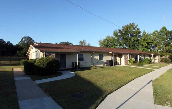
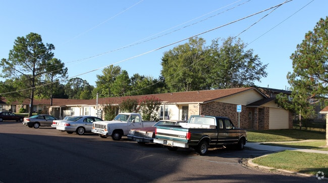
Property Record
1521 W Highland Dr, Jackson, MS 39204

NEARBY LISTINGS FOR SALE OR LEASE
-
-
View all Jackson listings for sale on LoopNet.com
Property Detail
1521 W Highland Dr
0696-0202-000
BEG 1348.46 FT N SW COR NW 1/4 SEC 7 T5 R1E E 766 FT TO POB N 200 FT NW/LY 206.43 FT N 150 FT E 450 FT S 400 FT E 150 FT S 150 FT W 550 FT TO POB 5.85 AC IN W 1/2 NW 1/4 SEC 7 T5N R1E
Apartment
Hinds
X
Mississippi
28049C0311J
5.85 AC
2024
West Jackson
2025
Jackson
003300
Jackson, MS
101,010 SF
DEMOGRAPHICS near 1521 W Highland Dr
1 Mile
3 Mile
5 Mile
2024 Total Population
6,387
52,100
99,539
2029 Population
6,329
50,570
95,849
Pop Growth 2024-2029
(0.91%)
(2.94%)
(3.71%)
Average Age
36
36
38
2024 Total Households
2,634
20,394
40,811
HH Growth 2024-2029
(1.03%)
(3.00%)
(3.82%)
Median Household Inc
$24,024
$29,200
$31,043
Avg Household Size
2.30
2.40
2.30
2024 Avg HH Vehicles
2.00
2.00
2.00
Median Home Value
$72,815
$59,206
$69,912
Median Year Built
1970
1965
1968
Nearby Places
Map Layers
Map Styles
 Street
 Aerial
- Restaurants
- Banks
- Shops
- Fitness
- Groceries
PUBLIC TRANSPORTATION
COMMUTER RAIL
Jackson (City of New Orleans - Amtrak)
DRIVE
WALK
Distance
Jackson (City of New Orleans - Amtrak)
7 min
3.8 mi
AIRPORT
Jackson-Medgar Wiley Evers International
DRIVE
WALK
Distance
Jackson-Medgar Wiley Evers International
23 min
14.3 mi
Freight Ports
Port of Greater Baton Rouge
DRIVE
WALK
Distance
Port of Greater Baton Rouge
198 min
176.6 mi
Nearby Properties
Address
Land Use
TOTAL SIZE
Lot Size
Zoning
Address
Land Use
TOTAL SIZE
Lot Size
Zoning
113,434 SF
82.60 AC
Address
Land Use
TOTAL SIZE
Lot Size
Zoning
191,128 SF
29.57 AC
Address
Land Use
TOTAL SIZE
Lot Size
Zoning
145,789 SF
6 AC
Address
Land Use
TOTAL SIZE
Lot Size
Zoning
192,048 SF
23.70 AC
Address
Land Use
TOTAL SIZE
Lot Size
Zoning
10,100 SF
548 AC
Address
Land Use
TOTAL SIZE
Lot Size
Zoning
45,186 SF
0.15 AC
Address
Land Use
TOTAL SIZE
Lot Size
Zoning
545,127 SF
36 AC
Address
Land Use
TOTAL SIZE
Lot Size
Zoning
62,857 SF
4.79 AC
Address
Land Use
TOTAL SIZE
Lot Size
Zoning
41,110 SF
4.48 AC
Address
Land Use
TOTAL SIZE
Lot Size
Zoning
72,000 SF
0.01 AC
Address
Land Use
TOTAL SIZE
Lot Size
Zoning
76,780 SF
4 AC
Address
Land Use
TOTAL SIZE
Lot Size
Zoning
Address
Land Use
TOTAL SIZE
Lot Size
Zoning
22,109 SF
1.96 AC
Address
Land Use
TOTAL SIZE
Lot Size
Zoning
108,878 SF
7.87 AC
Address
Land Use
TOTAL SIZE
Lot Size
Zoning
55,992 SF
2.44 AC
Address
Land Use
TOTAL SIZE
Lot Size
Zoning
199,954 SF
23 AC
Address
Land Use
TOTAL SIZE
Lot Size
Zoning
132,342 SF
4 AC
Address
Land Use
TOTAL SIZE
Lot Size
Zoning
36,159 SF
1.18 AC
Address
Land Use
TOTAL SIZE
Lot Size
Zoning
50,314 SF
115 AC
Address
Land Use
TOTAL SIZE
Lot Size
Zoning
Address
Land Use
TOTAL SIZE
Lot Size
Zoning
171,950 SF
9 AC
Address
Land Use
TOTAL SIZE
Lot Size
Zoning
138,086 SF
14 AC
Address
Land Use
TOTAL SIZE
Lot Size
Zoning
123,390 SF
15 AC
Address
Land Use
TOTAL SIZE
Lot Size
Zoning
223,892 SF
15 AC
Address
Land Use
TOTAL SIZE
Lot Size
Zoning
16,070 SF
6 AC
Address
Land Use
TOTAL SIZE
Lot Size
Zoning
11,950 SF
2 AC
Address
Land Use
TOTAL SIZE
Lot Size
Zoning
11,256 SF
3.60 AC
Address
Land Use
TOTAL SIZE
Lot Size
Zoning
16,665 SF
1.01 AC
Address
Land Use
TOTAL SIZE
Lot Size
Zoning
7.28 AC
Address
Land Use
TOTAL SIZE
Lot Size
Zoning
0.03 AC
The World's #1 Commercial Real Estate Marketplace
Connect with us
© 2026 CoStar Group
The information above has been obtained from sources believed reliable. While we do not doubt its accuracy we have not verified it and make no guarantee, warranty or representation about it. It is your responsibility to independently confirm its accuracy and completeness. Any projections, opinions, assumptions, or estimates used are for example only and do not represent the current or future performance of the property. The value of this transaction to you depends on tax and other factors which should be evaluated by your tax, financial, and legal advisors. You and your advisors should conduct a careful, independent investigation of the property to determine to your satisfaction the suitability of the property for your needs.