Property Record
1522 W Thorndale Ave, Chicago, IL 60660
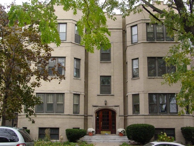

This Property Is For Sale
NEARBY LISTINGS FOR SALE OR LEASE
Property Detail
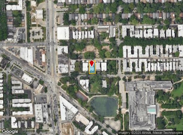
1522 W Thorndale Ave
Chicago-Naperville-Elgin, IL-IN-WI
Kransz Trustees Add To North Edgewater
14-05-300-027-0000
MARGRETH (KRANSZ)(TRUSTEES) ADD TO NORTH (EDGEWATER) SEC 05-40-14
Apartment
Cook
X
Illinois
17031C0406K
30,31
2023
0.17 AC
2024
Edgewater
030500
Chicago
10,713 SF
DEMOGRAPHICS near 1522 W Thorndale Ave
1 Mile
3 Mile
5 Mile
2024 Total Population
78,112
390,664
771,647
2029 Population
76,047
378,246
744,835
Pop Growth 2024-2029
(2.64%)
(3.18%)
(3.47%)
Average Age
40
39
38
2024 Total Households
38,441
178,147
345,043
HH Growth 2024-2029
(2.87%)
(3.40%)
(3.64%)
Median Household Inc
$57,951
$68,296
$79,597
Avg Household Size
1.90
2.10
2.10
2024 Avg HH Vehicles
1.00
1.00
1.00
Median Home Value
$293,323
$360,872
$409,977
Median Year Built
1949
1948
1949
Nearby Places
- Restaurants
- Banks
- Shops
- Fitness
- Groceries
PUBLIC TRANSPORTATION
TRANSIT/SUBWAY
Thorndale Station (Red Line - Chicago Transit Authority "L" Trains (The "L"))
DRIVE
WALK
Distance
Thorndale Station (Red Line - Chicago Transit Authority "L" Trains (The "L"))
2 min
10 min
0.5 mi
Granville Station (Red Line - Chicago Transit Authority "L" Trains (The "L"))
DRIVE
WALK
Distance
Granville Station (Red Line - Chicago Transit Authority "L" Trains (The "L"))
2 min
14 min
0.8 mi
Bryn Mawr Station (Red Line - Chicago Transit Authority "L" Trains (The "L"))
DRIVE
WALK
Distance
Bryn Mawr Station (Red Line - Chicago Transit Authority "L" Trains (The "L"))
2 min
15 min
0.8 mi
COMMUTER RAIL
Peterson/Ridge (Union Pacific North - Metra)
DRIVE
WALK
Distance
Peterson/Ridge (Union Pacific North - Metra)
1 min
7 min
0.4 mi
Rogers Park Station (Union Pacific North Line - Northeast Illinois Regional Commuter Railroad (Metra))
DRIVE
WALK
Distance
Rogers Park Station (Union Pacific North Line - Northeast Illinois Regional Commuter Railroad (Metra))
5 min
1.8 mi
AIRPORT
Chicago O'Hare International
DRIVE
WALK
Distance
Chicago O'Hare International
25 min
13.6 mi
Chicago Midway International
DRIVE
WALK
Distance
Chicago Midway International
31 min
20.7 mi
Freight Ports
Port Milwaukee
DRIVE
WALK
Distance
Port Milwaukee
99 min
77.7 mi
Nearby Properties
Address
Land Use
TOTAL SIZE
Lot Size
Zoning
Address
Land Use
TOTAL SIZE
Lot Size
Zoning
0.63 AC
PD 1372
Address
Land Use
TOTAL SIZE
Lot Size
Zoning
Address
Land Use
TOTAL SIZE
Lot Size
Zoning
0.96 AC
PD 958
Address
Land Use
TOTAL SIZE
Lot Size
Zoning
301,100 SF
2.20 AC
PD 37
Address
Land Use
TOTAL SIZE
Lot Size
Zoning
1 AC
RS-3
Address
Land Use
TOTAL SIZE
Lot Size
Zoning
305,592 SF
27.35 AC
Address
Land Use
TOTAL SIZE
Lot Size
Zoning
82,139 SF
4.88 AC
Address
Land Use
TOTAL SIZE
Lot Size
Zoning
21.56 AC
RS-2
Address
Land Use
TOTAL SIZE
Lot Size
Zoning
PD 184
Address
Land Use
TOTAL SIZE
Lot Size
Zoning
892,012 SF
37.29 AC
Address
Land Use
TOTAL SIZE
Lot Size
Zoning
147,835 SF
1.03 AC
PD 37
Address
Land Use
TOTAL SIZE
Lot Size
Zoning
170,538 SF
0.76 AC
PD 112
Address
Land Use
TOTAL SIZE
Lot Size
Zoning
201,600 SF
1.93 AC
PD 92
Address
Land Use
TOTAL SIZE
Lot Size
Zoning
2.25 AC
PD 612
Address
Land Use
TOTAL SIZE
Lot Size
Zoning
139.71 AC
PD 184
Address
Land Use
TOTAL SIZE
Lot Size
Zoning
1.35 AC
PD 1194
Address
Land Use
TOTAL SIZE
Lot Size
Zoning
226,345 SF
3.71 AC
PD 1203
Address
Land Use
TOTAL SIZE
Lot Size
Zoning
197,785 SF
4.03 AC
PD 943
Address
Land Use
TOTAL SIZE
Lot Size
Zoning
32,200 SF
5.67 AC
B3-5,RM-6.
Address
Land Use
TOTAL SIZE
Lot Size
Zoning
150,448 SF
0.96 AC
PD 958
Address
Land Use
TOTAL SIZE
Lot Size
Zoning
63,700 SF
7.42 AC
PD 796
Address
Land Use
TOTAL SIZE
Lot Size
Zoning
0.64 AC
PD 958
Address
Land Use
TOTAL SIZE
Lot Size
Zoning
24,400 SF
0.50 AC
B3-2
Address
Land Use
TOTAL SIZE
Lot Size
Zoning
5.48 AC
RT-4,PD 10
Address
Land Use
TOTAL SIZE
Lot Size
Zoning
1.01 AC
RM-6,POS-1
Address
Land Use
TOTAL SIZE
Lot Size
Zoning
0.16 AC
RM-6
Address
Land Use
TOTAL SIZE
Lot Size
Zoning
145,031 SF
1.90 AC
PD 372
Address
Land Use
TOTAL SIZE
Lot Size
Zoning
0.23 AC
B3-3
Address
Land Use
TOTAL SIZE
Lot Size
Zoning
223,366 SF
0.65 AC
Address
Land Use
TOTAL SIZE
Lot Size
Zoning
47,014 SF
0.57 AC
B3-2
The World's #1 Commercial Real Estate Marketplace
Connect with us
© 2025 CoStar Group
The information above has been obtained from sources believed reliable. While we do not doubt its accuracy we have not verified it and make no guarantee, warranty or representation about it. It is your responsibility to independently confirm its accuracy and completeness. Any projections, opinions, assumptions, or estimates used are for example only and do not represent the current or future performance of the property. The value of this transaction to you depends on tax and other factors which should be evaluated by your tax, financial, and legal advisors. You and your advisors should conduct a careful, independent investigation of the property to determine to your satisfaction the suitability of the property for your needs.