Property Record
1522 Malloy Bridge Cir, Ferris, TX 75125


NEARBY LISTINGS FOR SALE OR LEASE
Property Detail
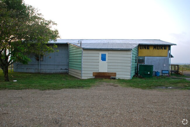
1522 Malloy Bridge Cir
Dallas-Fort Worth-Arlington, TX
Best Truck Parking
65098829010040000
BEST TRUCK PARKING BLK 1 LT 1 ACS 2.9429 INT202200110153 DD04152022 CO-DC 0988290100400 4NT09882901
Autorepair
Dallas
X
Texas
48113C0660K
1
2024
2.94 AC
2025
Southeast Outlying
016903
Dallas/Ft Worth
4,800 SF
DEMOGRAPHICS near 1522 Malloy Bridge Cir
1 Mile
3 Mile
5 Mile
2024 Total Population
109
4,096
14,418
2029 Population
117
4,680
16,505
Pop Growth 2024-2029
+ 7.34%
+ 14.26%
+ 14.47%
Average Age
33
34
35
2024 Total Households
33
1,278
4,537
HH Growth 2024-2029
+ 6.06%
+ 14.79%
+ 15.03%
Median Household Inc
$54,500
$56,228
$56,448
Avg Household Size
3.30
3.20
3.10
2024 Avg HH Vehicles
2.00
2.00
2.00
Median Home Value
$116,667
$119,014
$138,465
Median Year Built
2007
2000
1994
Nearby Places
Map Layers
Map Styles
 Street
 Aerial
- Restaurants
- Banks
- Shops
- Fitness
- Groceries
PUBLIC TRANSPORTATION
AIRPORT
Dallas Love Field
DRIVE
WALK
Distance
Dallas Love Field
36 min
25.1 mi
Freight Ports
Port of Shreveport
DRIVE
WALK
Distance
Port of Shreveport
212 min
190.2 mi
SALE & LEASE HISTORY
LISTING DATE
SALE/LEASE

Mar 30, 2022
For Sale
Nearby Properties
Address
Land Use
TOTAL SIZE
Lot Size
Zoning
Address
Land Use
TOTAL SIZE
Lot Size
Zoning
62.41 AC
Z31
Address
Land Use
TOTAL SIZE
Lot Size
Zoning
36.33 AC
Z31
Address
Land Use
TOTAL SIZE
Lot Size
Zoning
1,409,184 SF
75.72 AC
Z31
Address
Land Use
TOTAL SIZE
Lot Size
Zoning
1,021,601 SF
79.42 AC
Z268
Address
Land Use
TOTAL SIZE
Lot Size
Zoning
1,020,000 SF
56.30 AC
Z31
Address
Land Use
TOTAL SIZE
Lot Size
Zoning
750,000 SF
37.12 AC
Z31
Address
Land Use
TOTAL SIZE
Lot Size
Zoning
481,520 SF
26.82 AC
Z31
Address
Land Use
TOTAL SIZE
Lot Size
Zoning
202,439 SF
12.48 AC
Z31
Address
Land Use
TOTAL SIZE
Lot Size
Zoning
392,066 SF
23.52 AC
Address
Land Use
TOTAL SIZE
Lot Size
Zoning
266,199 SF
33.27 AC
Address
Land Use
TOTAL SIZE
Lot Size
Zoning
370,139 SF
15.42 AC
Z268
Address
Land Use
TOTAL SIZE
Lot Size
Zoning
376,368 SF
19.42 AC
Z31
Address
Land Use
TOTAL SIZE
Lot Size
Zoning
80,980 SF
15.18 AC
AG
Address
Land Use
TOTAL SIZE
Lot Size
Zoning
174,802 SF
8.67 AC
Address
Land Use
TOTAL SIZE
Lot Size
Zoning
235,368 SF
21.03 AC
Z05
Address
Land Use
TOTAL SIZE
Lot Size
Zoning
143,771 SF
130.33 AC
Z123
Address
Land Use
TOTAL SIZE
Lot Size
Zoning
174,802 SF
8.67 AC
Z05
Address
Land Use
TOTAL SIZE
Lot Size
Zoning
97,372 SF
42.82 AC
Z31
Address
Land Use
TOTAL SIZE
Lot Size
Zoning
12,444 SF
5 AC
Address
Land Use
TOTAL SIZE
Lot Size
Zoning
84.71 AC
Z268
Address
Land Use
TOTAL SIZE
Lot Size
Zoning
1,400 SF
75.81 AC
Z05
Address
Land Use
TOTAL SIZE
Lot Size
Zoning
53,610 SF
15 AC
Z31
Address
Land Use
TOTAL SIZE
Lot Size
Zoning
27,152 SF
71.21 AC
Z268
Address
Land Use
TOTAL SIZE
Lot Size
Zoning
13,000 SF
4.99 AC
Address
Land Use
TOTAL SIZE
Lot Size
Zoning
20.01 AC
Z05
Address
Land Use
TOTAL SIZE
Lot Size
Zoning
129.50 AC
Z268
Address
Land Use
TOTAL SIZE
Lot Size
Zoning
25,780 SF
100.30 AC
Z05
Address
Land Use
TOTAL SIZE
Lot Size
Zoning
122.47 AC
Z268
Address
Land Use
TOTAL SIZE
Lot Size
Zoning
26.47 AC
Z05
Address
Land Use
TOTAL SIZE
Lot Size
Zoning
62.30 AC
Z31
The World's #1 Commercial Real Estate Marketplace
Connect with us
© 2026 CoStar Group
The information above has been obtained from sources believed reliable. While we do not doubt its accuracy we have not verified it and make no guarantee, warranty or representation about it. It is your responsibility to independently confirm its accuracy and completeness. Any projections, opinions, assumptions, or estimates used are for example only and do not represent the current or future performance of the property. The value of this transaction to you depends on tax and other factors which should be evaluated by your tax, financial, and legal advisors. You and your advisors should conduct a careful, independent investigation of the property to determine to your satisfaction the suitability of the property for your needs.