Property Record
1523 High Falls Rd, Griffin, GA 30223

NEARBY LISTINGS FOR SALE OR LEASE
-
-
View all Griffin listings for sale on LoopNet.com
Property Detail
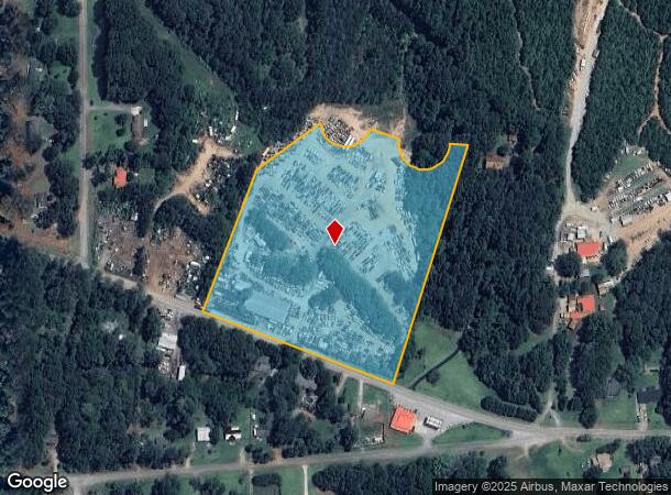
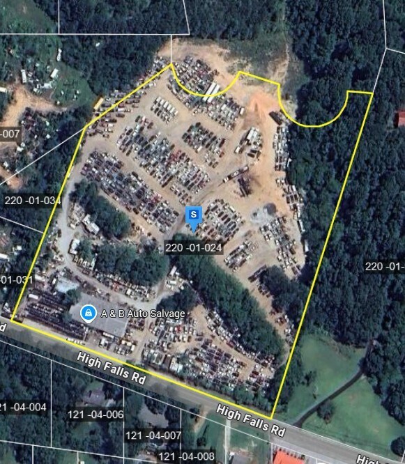
1523 High Falls Rd
220-01-024
Riley Heights
Autorepair
8.40AC HIGH FALLS RD DB 4501/318
X
Spalding
13255C0205E
Georgia
2024
8.40 AC
2024
W Henry/Spalding
160900
Atlanta
7,200 SF
Atlanta-Sandy Springs-Roswell, GA
DEMOGRAPHICS near 1523 High Falls Rd
1 Mile
3 Mile
5 Mile
2024 Total Population
1,141
15,811
44,722
2029 Population
1,274
17,731
50,184
Pop Growth 2024-2029
+ 11.66%
+ 12.14%
+ 12.21%
Average Age
38
39
40
2024 Total Households
411
6,100
17,225
HH Growth 2024-2029
+ 11.68%
+ 12.26%
+ 12.40%
Median Household Inc
$48,472
$54,510
$53,868
Avg Household Size
2.70
2.50
2.50
2024 Avg HH Vehicles
2.00
2.00
2.00
Median Home Value
$131,579
$231,327
$234,465
Median Year Built
1967
1974
1978
Nearby Places
Map Layers
Map Styles
 Street
 Aerial
- Restaurants
- Banks
- Shops
- Fitness
- Groceries
Nearby Properties
Address
Land Use
TOTAL SIZE
Lot Size
Zoning
Address
Land Use
TOTAL SIZE
Lot Size
Zoning
303,594 SF
58.69 AC
PDD
Address
Land Use
TOTAL SIZE
Lot Size
Zoning
210,196 SF
14.92 AC
PCD
Address
Land Use
TOTAL SIZE
Lot Size
Zoning
56,415 SF
0.56 AC
PCD
Address
Land Use
TOTAL SIZE
Lot Size
Zoning
367,793 SF
223.84 AC
C2
Address
Land Use
TOTAL SIZE
Lot Size
Zoning
70,817 SF
0.79 AC
CBD
Address
Land Use
TOTAL SIZE
Lot Size
Zoning
13,392 SF
31.70 AC
Address
Land Use
TOTAL SIZE
Lot Size
Zoning
305,123 SF
37 AC
C2
Address
Land Use
TOTAL SIZE
Lot Size
Zoning
16,394 SF
24.32 AC
LDRB
Address
Land Use
TOTAL SIZE
Lot Size
Zoning
73.71 AC
AR1
Address
Land Use
TOTAL SIZE
Lot Size
Zoning
216,242 SF
15.21 AC
C2
Address
Land Use
TOTAL SIZE
Lot Size
Zoning
92,331 SF
29.84 AC
C2
Address
Land Use
TOTAL SIZE
Lot Size
Zoning
39,105 SF
33.98 AC
PDD
Address
Land Use
TOTAL SIZE
Lot Size
Zoning
84,105 SF
17 AC
AR1
Address
Land Use
TOTAL SIZE
Lot Size
Zoning
293,260 SF
23.27 AC
C-2
Address
Land Use
TOTAL SIZE
Lot Size
Zoning
16 AC
PCD
Address
Land Use
TOTAL SIZE
Lot Size
Zoning
54,980 SF
1.09 AC
CBD
Address
Land Use
TOTAL SIZE
Lot Size
Zoning
48,856 SF
35.46 AC
PDD
Address
Land Use
TOTAL SIZE
Lot Size
Zoning
99,469 SF
28.98 AC
R-2
Address
Land Use
TOTAL SIZE
Lot Size
Zoning
72,876 SF
16.23 AC
PDD
Address
Land Use
TOTAL SIZE
Lot Size
Zoning
39,105 SF
33.98 AC
PDD
Address
Land Use
TOTAL SIZE
Lot Size
Zoning
48,856 SF
33.47 AC
PDD
Address
Land Use
TOTAL SIZE
Lot Size
Zoning
4,118 SF
14.40 AC
PID
Address
Land Use
TOTAL SIZE
Lot Size
Zoning
62,748 SF
22 AC
PDD
Address
Land Use
TOTAL SIZE
Lot Size
Zoning
65,058 SF
3.74 AC
Address
Land Use
TOTAL SIZE
Lot Size
Zoning
39,130 SF
4.01 AC
CBD
Address
Land Use
TOTAL SIZE
Lot Size
Zoning
205,953 SF
17.81 AC
PID
Address
Land Use
TOTAL SIZE
Lot Size
Zoning
14,680 SF
1.89 AC
PCD
Address
Land Use
TOTAL SIZE
Lot Size
Zoning
59,700 SF
2.20 AC
CBD
Address
Land Use
TOTAL SIZE
Lot Size
Zoning
203,804 SF
10.76 AC
C2
Address
Land Use
TOTAL SIZE
Lot Size
Zoning
337.38 AC
AAR
The World's #1 Commercial Real Estate Marketplace
Connect with us
© 2025 CoStar Group
The information above has been obtained from sources believed reliable. While we do not doubt its accuracy we have not verified it and make no guarantee, warranty or representation about it. It is your responsibility to independently confirm its accuracy and completeness. Any projections, opinions, assumptions, or estimates used are for example only and do not represent the current or future performance of the property. The value of this transaction to you depends on tax and other factors which should be evaluated by your tax, financial, and legal advisors. You and your advisors should conduct a careful, independent investigation of the property to determine to your satisfaction the suitability of the property for your needs.