Property Record
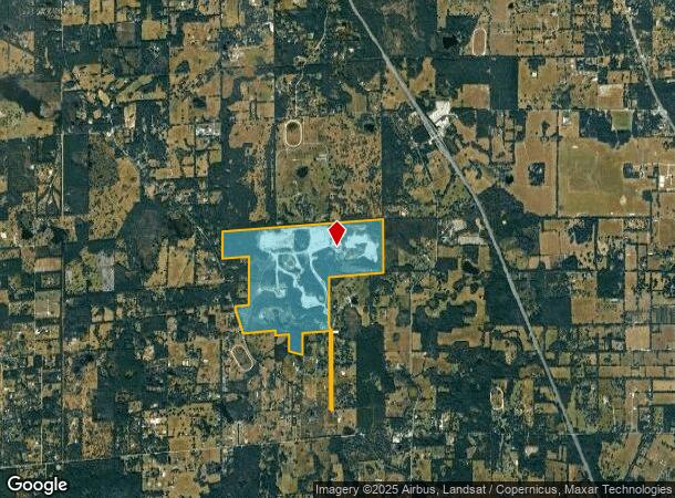
15249 N Highway 329, Reddick, FL 32686
NEARBY LISTINGS FOR SALE OR LEASE
-
-
View all Reddick listings for sale on LoopNet.com
Property Detail
15249 N Highway 329
05818-002-00
SEC 01 TWP 13 RGE 20 BEG AT THE SE COR OF THE NE 1/4 TH N 03-45-59 E 2630.02 FT TH S 89-53-18 W 2646.87 FT TH S 89-56-04 W 2647.12 FT TH S 89-53-01 W 2652.22 FT TH S 14-50-48 W 1333.08 FT TH N 89-52-12 E 1328.41 FT TH S 04-48-34 W 1328.94 FT TH S 04-
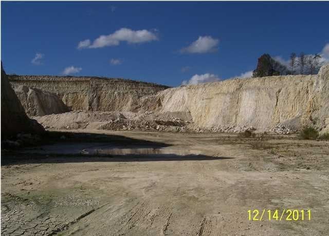
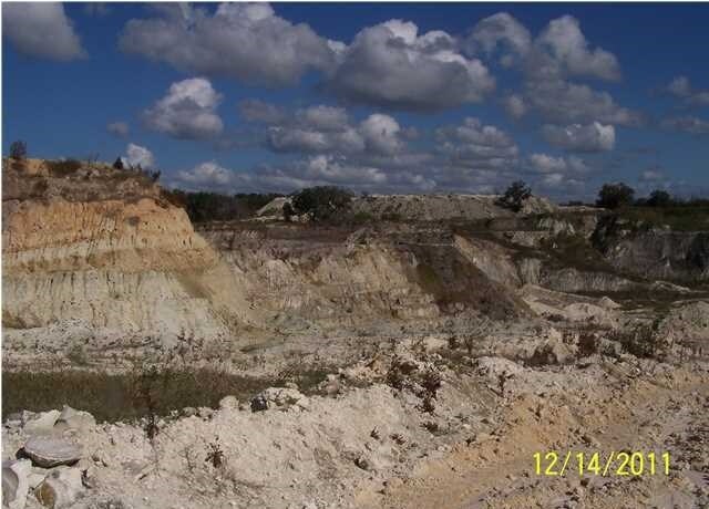
Miningfacilityoilgasmineralpreciousmetals
Marion
AE
Florida
12083C0119D
719.20 AC
2025
Outlying Marion County
2025
Ocala
000101
Ocala, FL
1,839 SF
DEMOGRAPHICS near 15249 N Highway 329
1 Mile
3 Mile
5 Mile
2024 Total Population
169
1,607
5,350
2029 Population
194
1,839
6,015
Pop Growth 2024-2029
+ 14.79%
+ 14.44%
+ 12.43%
Average Age
47
47
46
2024 Total Households
71
678
2,186
HH Growth 2024-2029
+ 15.49%
+ 14.45%
+ 12.53%
Median Household Inc
$59,999
$68,999
$56,476
Avg Household Size
2.30
2.30
2.30
2024 Avg HH Vehicles
2.00
2.00
2.00
Median Home Value
$319,231
$317,323
$283,367
Median Year Built
1989
1992
1987
Nearby Places
Map Layers
Map Styles
 Street
 Aerial
- Restaurants
- Banks
- Shops
- Fitness
- Groceries
PUBLIC TRANSPORTATION
AIRPORT
Gainesville Regional
DRIVE
WALK
Distance
Gainesville Regional
45 min
26.8 mi
Freight Ports
Jacksonville Port
DRIVE
WALK
Distance
Jacksonville Port
131 min
96.6 mi
Nearby Properties
Address
Land Use
TOTAL SIZE
Lot Size
Zoning
Address
Land Use
TOTAL SIZE
Lot Size
Zoning
11,331 SF
74.32 AC
PRV
Address
Land Use
TOTAL SIZE
Lot Size
Zoning
47,039 SF
39.61 AC
A1
Address
Land Use
TOTAL SIZE
Lot Size
Zoning
38,715 SF
50 AC
B3
Address
Land Use
TOTAL SIZE
Lot Size
Zoning
1,839 SF
719.20 AC
A1
Address
Land Use
TOTAL SIZE
Lot Size
Zoning
2,616 SF
41.47 AC
PUD
Address
Land Use
TOTAL SIZE
Lot Size
Zoning
5,986 SF
109.29 AC
A1
Address
Land Use
TOTAL SIZE
Lot Size
Zoning
11,063 SF
417.23 AC
A1
Address
Land Use
TOTAL SIZE
Lot Size
Zoning
4,916 SF
39.29 AC
A1
Address
Land Use
TOTAL SIZE
Lot Size
Zoning
7,939 SF
150.27 AC
A1
Address
Land Use
TOTAL SIZE
Lot Size
Zoning
5,828 SF
148.39 AC
A1
Address
Land Use
TOTAL SIZE
Lot Size
Zoning
7,192 SF
115.44 AC
A1
Address
Land Use
TOTAL SIZE
Lot Size
Zoning
6,805 SF
21.24 AC
A1
Address
Land Use
TOTAL SIZE
Lot Size
Zoning
6,456 SF
80.04 AC
A1
Address
Land Use
TOTAL SIZE
Lot Size
Zoning
6,205 SF
62.90 AC
A1
Address
Land Use
TOTAL SIZE
Lot Size
Zoning
6,583 SF
61.38 AC
A1
Address
Land Use
TOTAL SIZE
Lot Size
Zoning
11,280 SF
9.01 AC
B2
Address
Land Use
TOTAL SIZE
Lot Size
Zoning
5,625 SF
5.84 AC
A1
Address
Land Use
TOTAL SIZE
Lot Size
Zoning
83.57 AC
A1
Address
Land Use
TOTAL SIZE
Lot Size
Zoning
5,449 SF
33.83 AC
A1
Address
Land Use
TOTAL SIZE
Lot Size
Zoning
4,674 SF
15.27 AC
A1
Address
Land Use
TOTAL SIZE
Lot Size
Zoning
21,655 SF
33.01 AC
A1
Address
Land Use
TOTAL SIZE
Lot Size
Zoning
4,000 SF
158 AC
A1
Address
Land Use
TOTAL SIZE
Lot Size
Zoning
4,525 SF
46.16 AC
A1
Address
Land Use
TOTAL SIZE
Lot Size
Zoning
5 AC
B2
Address
Land Use
TOTAL SIZE
Lot Size
Zoning
6,497 SF
32.76 AC
A1
Address
Land Use
TOTAL SIZE
Lot Size
Zoning
5,378 SF
23.95 AC
A1
Address
Land Use
TOTAL SIZE
Lot Size
Zoning
9,353 SF
1.47 AC
A1
Address
Land Use
TOTAL SIZE
Lot Size
Zoning
2,655 SF
13.70 AC
A1
Address
Land Use
TOTAL SIZE
Lot Size
Zoning
4,035 SF
20.02 AC
A1
Address
Land Use
TOTAL SIZE
Lot Size
Zoning
5,635 SF
80.85 AC
A1
The World's #1 Commercial Real Estate Marketplace
Connect with us
© 2026 CoStar Group
The information above has been obtained from sources believed reliable. While we do not doubt its accuracy we have not verified it and make no guarantee, warranty or representation about it. It is your responsibility to independently confirm its accuracy and completeness. Any projections, opinions, assumptions, or estimates used are for example only and do not represent the current or future performance of the property. The value of this transaction to you depends on tax and other factors which should be evaluated by your tax, financial, and legal advisors. You and your advisors should conduct a careful, independent investigation of the property to determine to your satisfaction the suitability of the property for your needs.