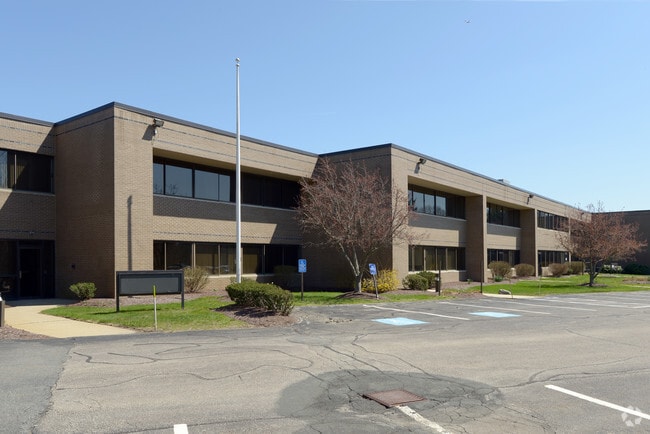
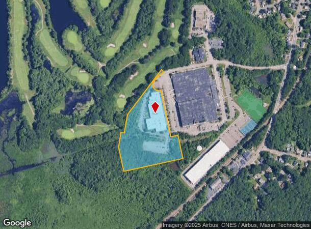
Property Record
1525 Braxton St, Braintree, MA 02184

NEARBY LISTINGS FOR SALE OR LEASE
Property Detail
1525 Braxton St
BRAI-001053-000000-000012D
Norfolk
Manufacturinglight
Massachusetts
AE
12d
25021C0217F
10.14 AC
2025
Quincy/Braintree
2025
Boston
419800
Boston-Cambridge-Newton, MA-NH
87,876 SF
DEMOGRAPHICS near 1525 Braxton St
1 Mile
3 Mile
5 Mile
2024 Total Population
7,133
74,046
203,822
2029 Population
7,070
73,416
202,496
Pop Growth 2024-2029
(0.88%)
(0.85%)
(0.65%)
Average Age
42
42
42
2024 Total Households
2,527
27,321
82,949
HH Growth 2024-2029
(0.99%)
(0.83%)
(0.64%)
Median Household Inc
$119,342
$104,255
$94,727
Avg Household Size
2.80
2.60
2.40
2024 Avg HH Vehicles
2.00
2.00
2.00
Median Home Value
$647,581
$490,215
$496,593
Median Year Built
1958
1961
1963
Nearby Places
Map Layers
Map Styles
 Street
 Aerial
- Restaurants
- Banks
- Shops
- Fitness
- Groceries
PUBLIC TRANSPORTATION
COMMUTER RAIL
Braintree (Kingston/Plymouth Line - Massachusetts Bay Transportation Authority Commuter Rail (Purple Line), Middleborough/Lakeville Line - Massachusetts Bay Transportation Authority Commuter Rail (Purple Line))
DRIVE
WALK
Distance
Braintree (Kingston/Plymouth Line - Massachusetts Bay Transportation Authority Commuter Rail (Purple Line), Middleborough/Lakeville Line - Massachusetts Bay Transportation Authority Commuter Rail (Purple Line))
6 min
1.5 mi
Holbrook/Randolph (Middleborough/Lakeville Line - Massachusetts Bay Transportation Authority Commuter Rail (Purple Line))
DRIVE
WALK
Distance
Holbrook/Randolph (Middleborough/Lakeville Line - Massachusetts Bay Transportation Authority Commuter Rail (Purple Line))
7 min
2.8 mi
AIRPORT
General Edward Lawrence Logan International
DRIVE
WALK
Distance
General Edward Lawrence Logan International
26 min
17.8 mi
SALE & LEASE HISTORY
LISTING DATE
SALE/LEASE

Aug 24, 2018
For Lease
Nearby Properties
Address
Land Use
TOTAL SIZE
Lot Size
Zoning
Address
Land Use
TOTAL SIZE
Lot Size
Zoning
50.61 AC
IND
Address
Land Use
TOTAL SIZE
Lot Size
Zoning
15.81 AC
Address
Land Use
TOTAL SIZE
Lot Size
Zoning
235,150 SF
36.67 AC
R1
Address
Land Use
TOTAL SIZE
Lot Size
Zoning
38.48 AC
B
Address
Land Use
TOTAL SIZE
Lot Size
Zoning
240,481 SF
25.23 AC
CL2
Address
Land Use
TOTAL SIZE
Lot Size
Zoning
16.08 AC
OSC
Address
Land Use
TOTAL SIZE
Lot Size
Zoning
0.25 AC
I
Address
Land Use
TOTAL SIZE
Lot Size
Zoning
132,143 SF
23.70 AC
RH
Address
Land Use
TOTAL SIZE
Lot Size
Zoning
395,130 SF
6.50 AC
IND
Address
Land Use
TOTAL SIZE
Lot Size
Zoning
18.76 AC
GBD
Address
Land Use
TOTAL SIZE
Lot Size
Zoning
167,076 SF
16 AC
A
Address
Land Use
TOTAL SIZE
Lot Size
Zoning
10.10 AC
CSBD
Address
Land Use
TOTAL SIZE
Lot Size
Zoning
80,226 SF
6.60 AC
RES
Address
Land Use
TOTAL SIZE
Lot Size
Zoning
494,520 SF
20.80 AC
IND
Address
Land Use
TOTAL SIZE
Lot Size
Zoning
138,400 SF
55.71 AC
RM
Address
Land Use
TOTAL SIZE
Lot Size
Zoning
146,402 SF
10 AC
RES
Address
Land Use
TOTAL SIZE
Lot Size
Zoning
22.64 AC
B
Address
Land Use
TOTAL SIZE
Lot Size
Zoning
76,223 SF
19.83 AC
B
Address
Land Use
TOTAL SIZE
Lot Size
Zoning
150,000 SF
11.91 AC
HBD
Address
Land Use
TOTAL SIZE
Lot Size
Zoning
114,176 SF
11.69 AC
RH
Address
Land Use
TOTAL SIZE
Lot Size
Zoning
162,909 SF
7.02 AC
HBD
Address
Land Use
TOTAL SIZE
Lot Size
Zoning
1.48 AC
100
Address
Land Use
TOTAL SIZE
Lot Size
Zoning
34.28 AC
85
Address
Land Use
TOTAL SIZE
Lot Size
Zoning
154,600 SF
8.07 AC
HBD
Address
Land Use
TOTAL SIZE
Lot Size
Zoning
46.19 AC
RES
Address
Land Use
TOTAL SIZE
Lot Size
Zoning
7.50 AC
HBD
Address
Land Use
TOTAL SIZE
Lot Size
Zoning
4.77 AC
HBD
Address
Land Use
TOTAL SIZE
Lot Size
Zoning
152,250 SF
5.38 AC
HBD
Address
Land Use
TOTAL SIZE
Lot Size
Zoning
8.86 AC
HBD
Address
Land Use
TOTAL SIZE
Lot Size
Zoning
154,550 SF
14.18 AC
HBD
The World's #1 Commercial Real Estate Marketplace
Connect with us
© 2025 CoStar Group
The information above has been obtained from sources believed reliable. While we do not doubt its accuracy we have not verified it and make no guarantee, warranty or representation about it. It is your responsibility to independently confirm its accuracy and completeness. Any projections, opinions, assumptions, or estimates used are for example only and do not represent the current or future performance of the property. The value of this transaction to you depends on tax and other factors which should be evaluated by your tax, financial, and legal advisors. You and your advisors should conduct a careful, independent investigation of the property to determine to your satisfaction the suitability of the property for your needs.