Property Record
1525 Greenspring Valley Rd, Stevenson, MD 21153


NEARBY LISTINGS FOR SALE OR LEASE
-
-
View all Stevenson listings for sale on LoopNet.com
Property Detail
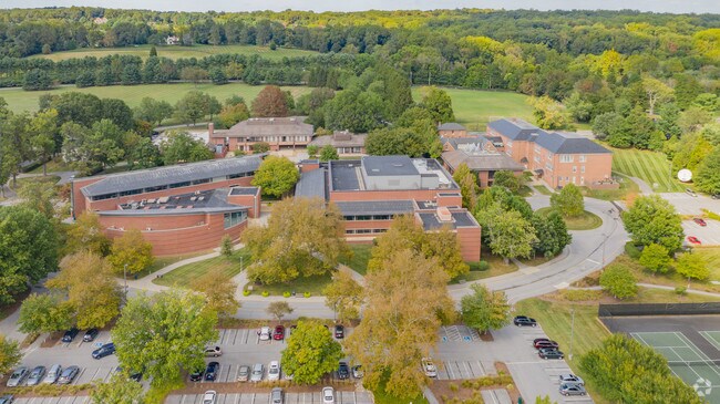
1525 Greenspring Valley Rd
Baltimore-Columbia-Towson, MD
Land Condominium Boulevard Corporate Cen
03-0322035480
60.2364 AC SS VALLEY
Taxexempt
Baltimore
X
Maryland
2400100240G
60.20 AC
0
Reisterstown Rd Corridor
2025
Baltimore
403801
DEMOGRAPHICS near 1525 Greenspring Valley Rd
1 Mile
3 Mile
5 Mile
2024 Total Population
873
26,301
163,706
2029 Population
853
25,859
160,265
Pop Growth 2024-2029
(2.29%)
(1.68%)
(2.10%)
Average Age
46
46
42
2024 Total Households
323
10,573
65,353
HH Growth 2024-2029
(2.48%)
(1.71%)
(2.19%)
Median Household Inc
$189,024
$135,382
$90,985
Avg Household Size
2.70
2.50
2.40
2024 Avg HH Vehicles
2.00
2.00
2.00
Median Home Value
$747,354
$580,233
$394,197
Median Year Built
1973
1982
1974
Nearby Places
Map Layers
Map Styles
 Street
 Aerial
- Restaurants
- Banks
- Shops
- Fitness
- Groceries
PUBLIC TRANSPORTATION
AIRPORT
Baltimore/Washington International Thurgood Marshall
DRIVE
WALK
Distance
Baltimore/Washington International Thurgood Marshall
37 min
21.1 mi
Freight Ports
Port of Baltimore
DRIVE
WALK
Distance
Port of Baltimore
31 min
15.4 mi
SALE & LEASE HISTORY
LISTING DATE
SALE/LEASE

Apr 11, 2019
For Sale
Nearby Properties
Address
Land Use
TOTAL SIZE
Lot Size
Zoning
Address
Land Use
TOTAL SIZE
Lot Size
Zoning
178,200 SF
5.58 AC
BR-CR
Address
Land Use
TOTAL SIZE
Lot Size
Zoning
99,153 SF
9.41 AC
OR2
Address
Land Use
TOTAL SIZE
Lot Size
Zoning
7.05 AC
BM
Address
Land Use
TOTAL SIZE
Lot Size
Zoning
73,186 SF
34 AC
Address
Land Use
TOTAL SIZE
Lot Size
Zoning
6.14 AC
02
Address
Land Use
TOTAL SIZE
Lot Size
Zoning
145,800 SF
44 SF
Address
Land Use
TOTAL SIZE
Lot Size
Zoning
9,573 SF
10.52 AC
BM
Address
Land Use
TOTAL SIZE
Lot Size
Zoning
91,000 SF
15 AC
DR2
Address
Land Use
TOTAL SIZE
Lot Size
Zoning
8.49 AC
OR2
Address
Land Use
TOTAL SIZE
Lot Size
Zoning
92,600 SF
21.41 AC
DR2
Address
Land Use
TOTAL SIZE
Lot Size
Zoning
9.54 AC
BR
Address
Land Use
TOTAL SIZE
Lot Size
Zoning
102,840 SF
9.10 AC
O3
Address
Land Use
TOTAL SIZE
Lot Size
Zoning
75,000 SF
8.70 AC
BL
Address
Land Use
TOTAL SIZE
Lot Size
Zoning
7.54 AC
DR16
Address
Land Use
TOTAL SIZE
Lot Size
Zoning
77,964 SF
5.44 AC
ORT
Address
Land Use
TOTAL SIZE
Lot Size
Zoning
136,836 SF
5.94 AC
ORT
Address
Land Use
TOTAL SIZE
Lot Size
Zoning
4.08 AC
02
Address
Land Use
TOTAL SIZE
Lot Size
Zoning
4.65 AC
ORT
Address
Land Use
TOTAL SIZE
Lot Size
Zoning
77,182 SF
1.39 AC
BLR
Address
Land Use
TOTAL SIZE
Lot Size
Zoning
77,372 SF
4.35 AC
BL
Address
Land Use
TOTAL SIZE
Lot Size
Zoning
Address
Land Use
TOTAL SIZE
Lot Size
Zoning
101,294 SF
3.72 AC
OR2
Address
Land Use
TOTAL SIZE
Lot Size
Zoning
111.85 AC
Address
Land Use
TOTAL SIZE
Lot Size
Zoning
11,296 SF
405.23 AC
RC5
Address
Land Use
TOTAL SIZE
Lot Size
Zoning
47,236 SF
36 AC
Address
Land Use
TOTAL SIZE
Lot Size
Zoning
Address
Land Use
TOTAL SIZE
Lot Size
Zoning
8.71 AC
DR16
Address
Land Use
TOTAL SIZE
Lot Size
Zoning
18,640 SF
109.03 AC
RC2
Address
Land Use
TOTAL SIZE
Lot Size
Zoning
31,530 SF
5.28 AC
RC5
The World's #1 Commercial Real Estate Marketplace
Connect with us
© 2025 CoStar Group
The information above has been obtained from sources believed reliable. While we do not doubt its accuracy we have not verified it and make no guarantee, warranty or representation about it. It is your responsibility to independently confirm its accuracy and completeness. Any projections, opinions, assumptions, or estimates used are for example only and do not represent the current or future performance of the property. The value of this transaction to you depends on tax and other factors which should be evaluated by your tax, financial, and legal advisors. You and your advisors should conduct a careful, independent investigation of the property to determine to your satisfaction the suitability of the property for your needs.