Property Record
1525 S 400 E, Springville, UT 84663
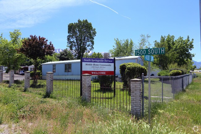

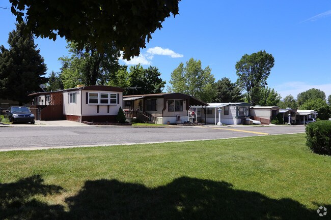

Property Detail
1525 S 400 E
Provo-Orem-Lehi, UT
COM E 42.76 FT & N 33 FT FR SW COR SE1/4 SEC 4, T8S, R3E, SLM; E 301.1 FT; N 2 DEG 20W 130.67 FT; E 72.38 FT; N 549.68 FT; N 87 DEG 20W 75.08 FT; S 40.57 FT; N 88 DEG 22W 408.78 FT; SELY ALONG ARC OF COMPOUND HIGHWAY CURVE TO LEFT 700 FT M OR L (CHD
26-039-0023
Utah
Commercialnec
Utah
2024
8.77 AC
2025
Central/South Utah County
003106
Salt Lake City
6,602 SF
NEARBY LISTINGS FOR SALE OR LEASE
DEMOGRAPHICS near 1525 S 400 E
1 mile
3 mile
5 mile
2025 Total Population
9,842
62,204
102,151
2030 Population
10,791
68,578
112,433
Pop Growth 2025-2030
+ 9.64%
+ 10.25%
+ 10.07%
Average Age
34
33
33
2025 Total Households
2,806
17,371
28,531
HH Growth 2025-2030
+ 10.12%
+ 10.85%
+ 10.74%
Median Household Inc
$96,219
$104,183
$103,217
Avg Household Size
3.50
3.60
3.60
2025 Avg HH Vehicles
2.00
2.00
3.00
Median Home Value
$609,375
$573,562
$544,545
Median Year Built
1987
2001
2000
Nearby Places
Map Layers
Map Styles
 Street
 Aerial
Layers
 Traffic
 Biking
Places
Listings with unknown addresses are not visible on the map
- Restaurants
- Banks
- Shops
- Fitness
- Groceries
PUBLIC TRANSPORTATION
COMMUTER RAIL
Provo Central Station (FrontRunner - Utah Transit Authority (UTA))
Drive
Walk
Distance
Provo Central Station (FrontRunner - Utah Transit Authority (UTA))
12 min
8.0 mi
Provo Amtrak (California Zephyr - Amtrak)
Drive
Walk
Distance
Provo Amtrak (California Zephyr - Amtrak)
13 min
8.0 mi
AIRPORT
Provo Municipal
Drive
Walk
Distance
Provo Municipal
16 min
10.0 mi
Freight Ports
Port of Stockton
Drive
Walk
Distance
Port of Stockton
766 min
746.5 mi
Nearby Properties
Address
Land Use
TOTAL SIZE
Lot Size
Zoning
Address
Land Use
TOTAL SIZE
Lot Size
Zoning
44,552 SF
29.78 AC
Address
Land Use
TOTAL SIZE
Lot Size
Zoning
565,605 SF
20 AC
Address
Land Use
TOTAL SIZE
Lot Size
Zoning
263,859 SF
12.80 AC
Address
Land Use
TOTAL SIZE
Lot Size
Zoning
281,008 SF
16.65 AC
Address
Land Use
TOTAL SIZE
Lot Size
Zoning
281,008 SF
14.84 AC
Address
Land Use
TOTAL SIZE
Lot Size
Zoning
301,852 SF
20.24 AC
Address
Land Use
TOTAL SIZE
Lot Size
Zoning
170,774 SF
9.70 AC
Address
Land Use
TOTAL SIZE
Lot Size
Zoning
243,888 SF
32.23 AC
Address
Land Use
TOTAL SIZE
Lot Size
Zoning
159,679 SF
12.91 AC
Address
Land Use
TOTAL SIZE
Lot Size
Zoning
322,432 SF
29.36 AC
Address
Land Use
TOTAL SIZE
Lot Size
Zoning
210,644 SF
19.55 AC
Address
Land Use
TOTAL SIZE
Lot Size
Zoning
125,729 SF
12.84 AC
Address
Land Use
TOTAL SIZE
Lot Size
Zoning
29,819 SF
13.51 AC
Address
Land Use
TOTAL SIZE
Lot Size
Zoning
184,079 SF
11.47 AC
Address
Land Use
TOTAL SIZE
Lot Size
Zoning
149,046 SF
12.10 AC
Address
Land Use
TOTAL SIZE
Lot Size
Zoning
141,566 SF
7.89 AC
Address
Land Use
TOTAL SIZE
Lot Size
Zoning
231,991 SF
13.76 AC
Address
Land Use
TOTAL SIZE
Lot Size
Zoning
79,260 SF
5.24 AC
Address
Land Use
TOTAL SIZE
Lot Size
Zoning
124,255 SF
9.87 AC
Address
Land Use
TOTAL SIZE
Lot Size
Zoning
112,094 SF
10.34 AC
Address
Land Use
TOTAL SIZE
Lot Size
Zoning
72,453 SF
14.17 AC
Address
Land Use
TOTAL SIZE
Lot Size
Zoning
181,993 SF
5.01 AC
Address
Land Use
TOTAL SIZE
Lot Size
Zoning
110,464 SF
6.23 AC
Address
Land Use
TOTAL SIZE
Lot Size
Zoning
96,879 SF
7.91 AC
Address
Land Use
TOTAL SIZE
Lot Size
Zoning
82,610 SF
2.46 AC
Address
Land Use
TOTAL SIZE
Lot Size
Zoning
82,610 SF
2.02 AC
Address
Land Use
TOTAL SIZE
Lot Size
Zoning
123,499 SF
19.83 AC
Address
Land Use
TOTAL SIZE
Lot Size
Zoning
64,385 SF
8.29 AC
Address
Land Use
TOTAL SIZE
Lot Size
Zoning
110,762 SF
6.08 AC
Address
Land Use
TOTAL SIZE
Lot Size
Zoning
62,203 SF
2.13 AC
The World's #1 Commercial Real Estate Marketplace
Connect with us
© 2026 CoStar Group
The information above has been obtained from sources believed reliable. While we do not doubt its accuracy we have not verified it and make no guarantee, warranty or representation about it. It is your responsibility to independently confirm its accuracy and completeness. Any projections, opinions, assumptions, or estimates used are for example only and do not represent the current or future performance of the property. The value of this transaction to you depends on tax and other factors which should be evaluated by your tax, financial, and legal advisors. You and your advisors should conduct a careful, independent investigation of the property to determine to your satisfaction the suitability of the property for your needs.