Property Record
15251 S Blackbob Rd, Olathe, KS 66062
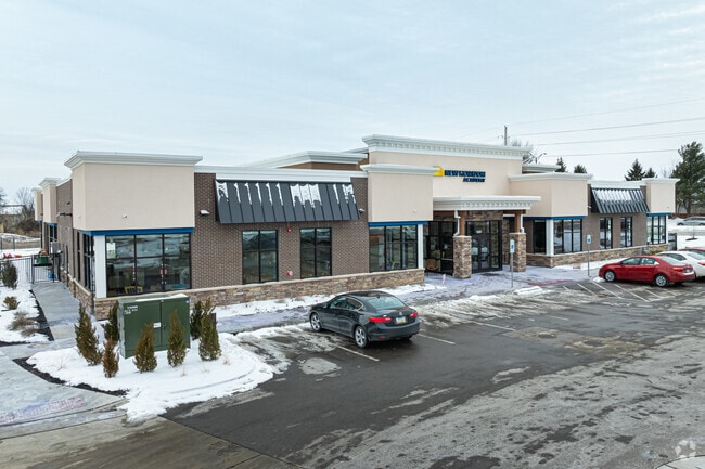


Property Detail
15251 S Blackbob Rd
DP49560000-009A
NEW HORIZON ACADEMY AT BLACK BOB 151 SHOPS, LOT 9A
Daycare
JOHNSON
C-2
Kansas
B and X Area of moderate flood hazard, usually the area between the limits of the 100-year and 500-year floods.
9a
2025
1.32 AC
2025
South Johnson County
053425
Kansas City
13,702 SF
Kansas City, MO-KS
NEARBY LISTINGS FOR SALE OR LEASE
DEMOGRAPHICS near 15251 S Blackbob Rd
1 mile
3 mile
5 mile
2025 Total Population
13,157
81,825
178,677
2030 Population
13,387
84,392
184,224
Pop Growth 2025-2030
+ 1.75%
+ 3.14%
+ 3.10%
Average Age
37
38
38
2025 Total Households
4,271
28,074
63,972
HH Growth 2025-2030
+ 1.85%
+ 3.23%
+ 3.19%
Median Household Inc
$138,711
$126,404
$115,661
Avg Household Size
3.00
2.80
2.70
2025 Avg HH Vehicles
2.00
2.00
2.00
Median Home Value
$358,066
$388,583
$398,730
Median Year Built
1994
1996
1994
Nearby Places
Map Layers
Map Styles
 Street
 Aerial
Layers
 Traffic
 Biking
Places
Listings with unknown addresses are not visible on the map
- Restaurants
- Banks
- Shops
- Fitness
- Groceries
PUBLIC TRANSPORTATION
AIRPORT
Kansas City International
Drive
Walk
Distance
Kansas City International
52 min
39.6 mi
Nearby Properties
Address
Land Use
TOTAL SIZE
Lot Size
Zoning
Address
Land Use
TOTAL SIZE
Lot Size
Zoning
512,643 SF
75.55 AC
AG
Address
Land Use
TOTAL SIZE
Lot Size
Zoning
211,054 SF
72.40 AC
R-1
Address
Land Use
TOTAL SIZE
Lot Size
Zoning
934,502 SF
34.09 AC
BP
Address
Land Use
TOTAL SIZE
Lot Size
Zoning
103,102 SF
31.90 AC
R-1
Address
Land Use
TOTAL SIZE
Lot Size
Zoning
32,992 SF
3.85 AC
R-4
Address
Land Use
TOTAL SIZE
Lot Size
Zoning
137,955 SF
23.80 AC
R-1
Address
Land Use
TOTAL SIZE
Lot Size
Zoning
129,325 SF
4.50 AC
R-1
Address
Land Use
TOTAL SIZE
Lot Size
Zoning
146,832 SF
30 AC
R-1
Address
Land Use
TOTAL SIZE
Lot Size
Zoning
150,122 SF
17.48 AC
R-1
Address
Land Use
TOTAL SIZE
Lot Size
Zoning
61,479 SF
8.14 AC
C-2
Address
Land Use
TOTAL SIZE
Lot Size
Zoning
157,344 SF
12.69 AC
R-1
Address
Land Use
TOTAL SIZE
Lot Size
Zoning
130,605 SF
18.01 AC
R-1
Address
Land Use
TOTAL SIZE
Lot Size
Zoning
86,095 SF
16.95 AC
R-1
Address
Land Use
TOTAL SIZE
Lot Size
Zoning
71,221 SF
17.13 AC
R-1
Address
Land Use
TOTAL SIZE
Lot Size
Zoning
69,855 SF
6.86 AC
R
Address
Land Use
TOTAL SIZE
Lot Size
Zoning
81,753 SF
20.88 AC
R-1
Address
Land Use
TOTAL SIZE
Lot Size
Zoning
213,098 SF
11.70 AC
M-2
Address
Land Use
TOTAL SIZE
Lot Size
Zoning
117,084 SF
10.69 AC
R-1
Address
Land Use
TOTAL SIZE
Lot Size
Zoning
71,221 SF
13.84 AC
R-1
Address
Land Use
TOTAL SIZE
Lot Size
Zoning
55,263 SF
10.81 AC
R-1A
Address
Land Use
TOTAL SIZE
Lot Size
Zoning
81,096 SF
121.30 AC
AG
Address
Land Use
TOTAL SIZE
Lot Size
Zoning
73,159 SF
12.54 AC
R-1
Address
Land Use
TOTAL SIZE
Lot Size
Zoning
92,328 SF
9.49 AC
M-1
Address
Land Use
TOTAL SIZE
Lot Size
Zoning
72,091 SF
11.33 AC
R-1
Address
Land Use
TOTAL SIZE
Lot Size
Zoning
81,229 SF
34.32 AC
CP-O
Address
Land Use
TOTAL SIZE
Lot Size
Zoning
69,723 SF
11.29 AC
R-1
Address
Land Use
TOTAL SIZE
Lot Size
Zoning
72,324 SF
8.84 AC
R-1
Address
Land Use
TOTAL SIZE
Lot Size
Zoning
65,691 SF
11.51 AC
RP-1
Address
Land Use
TOTAL SIZE
Lot Size
Zoning
62,832 SF
15.43 AC
CTY RUR
Address
Land Use
TOTAL SIZE
Lot Size
Zoning
54,005 SF
10.49 AC
R-1/PUD
The World's #1 Commercial Real Estate Marketplace
Connect with us
© 2026 CoStar Group
The information above has been obtained from sources believed reliable. While we do not doubt its accuracy we have not verified it and make no guarantee, warranty or representation about it. It is your responsibility to independently confirm its accuracy and completeness. Any projections, opinions, assumptions, or estimates used are for example only and do not represent the current or future performance of the property. The value of this transaction to you depends on tax and other factors which should be evaluated by your tax, financial, and legal advisors. You and your advisors should conduct a careful, independent investigation of the property to determine to your satisfaction the suitability of the property for your needs.