Property Record
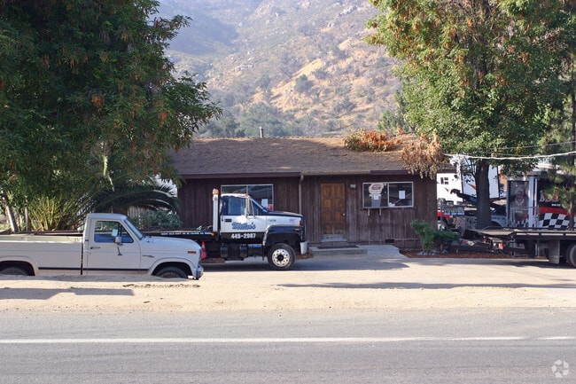
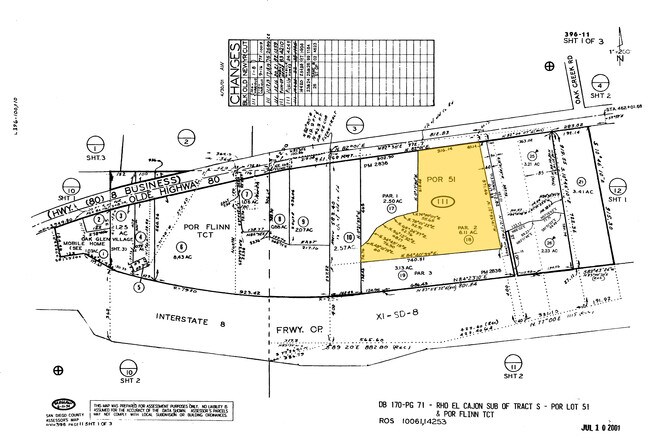
15275 Olde Highway 80, El Cajon, CA 92021

Property Detail
15275 Olde Highway 80
396-111-18
PAR 2 (EX HWY) TR PM02836
Shipyard
SAN DIEGO
M54
California
B and X Area of moderate flood hazard, usually the area between the limits of the 100-year and 500-year floods.
6.11 AC
2024
Outlying SD County S
2025
San Diego
016812
San Diego-Chula Vista-Carlsbad, CA
NEARBY LISTINGS FOR SALE OR LEASE
-
-
View all El Cajon listings for lease on LoopNet.com
DEMOGRAPHICS near 15275 Olde Highway 80
1 mile
3 mile
5 mile
2025 Total Population
1,630
15,155
58,717
2030 Population
1,597
15,138
58,855
Pop Growth 2025-2030
(2.02%)
(0.11%)
+ 0.24%
Average Age
50
45
42
2025 Total Households
661
5,459
20,592
HH Growth 2025-2030
(2.72%)
(0.35%)
+ 0.05%
Median Household Inc
$67,761
$116,243
$107,531
Avg Household Size
2.40
2.70
2.80
2025 Avg HH Vehicles
2.00
2.00
2.00
Median Home Value
$695,859
$734,595
$715,499
Median Year Built
1980
1986
1980
Nearby Places
Map Layers
Map Styles
 Street
 Aerial
Layers
 Traffic
 Biking
Places
Listings with unknown addresses are not visible on the map
- Restaurants
- Banks
- Shops
- Fitness
- Groceries
PUBLIC TRANSPORTATION
AIRPORT
San Diego International
Drive
Walk
Distance
San Diego International
36 min
25.6 mi
Freight Ports
Port of San Diego
Drive
Walk
Distance
Port of San Diego
34 min
24.5 mi
SALE & LEASE HISTORY
LISTING DATE
SALE/LEASE

Jul 31, 2024
For Lease
Nearby Properties
Address
Land Use
TOTAL SIZE
Lot Size
Zoning
Address
Land Use
TOTAL SIZE
Lot Size
Zoning
38.80 AC
RMH8
Address
Land Use
TOTAL SIZE
Lot Size
Zoning
35,424 SF
3.13 AC
RV
Address
Land Use
TOTAL SIZE
Lot Size
Zoning
38,483 SF
2.69 AC
M52
Address
Land Use
TOTAL SIZE
Lot Size
Zoning
19,169 SF
3.91 AC
C36
Address
Land Use
TOTAL SIZE
Lot Size
Zoning
5,574 SF
2.87 AC
M52
Address
Land Use
TOTAL SIZE
Lot Size
Zoning
4.93 AC
RV
Address
Land Use
TOTAL SIZE
Lot Size
Zoning
690 SF
8.43 AC
M52
Address
Land Use
TOTAL SIZE
Lot Size
Zoning
13,200 SF
1.16 AC
M52
Address
Land Use
TOTAL SIZE
Lot Size
Zoning
4 AC
RMH11
Address
Land Use
TOTAL SIZE
Lot Size
Zoning
188.24 AC
R1
Address
Land Use
TOTAL SIZE
Lot Size
Zoning
956 SF
4.80 AC
M54
Address
Land Use
TOTAL SIZE
Lot Size
Zoning
6,807 SF
2.23 AC
M54
Address
Land Use
TOTAL SIZE
Lot Size
Zoning
3.01 AC
A70
Address
Land Use
TOTAL SIZE
Lot Size
Zoning
45.01 AC
A70
Address
Land Use
TOTAL SIZE
Lot Size
Zoning
16,475 SF
1.19 AC
M52
Address
Land Use
TOTAL SIZE
Lot Size
Zoning
14.86 AC
A70
Address
Land Use
TOTAL SIZE
Lot Size
Zoning
254.18 AC
S92
Address
Land Use
TOTAL SIZE
Lot Size
Zoning
11,000 SF
1.11 AC
M52
Address
Land Use
TOTAL SIZE
Lot Size
Zoning
3,004 SF
18.02 AC
A70
Address
Land Use
TOTAL SIZE
Lot Size
Zoning
111.59 AC
R1
Address
Land Use
TOTAL SIZE
Lot Size
Zoning
3,860 SF
1.08 AC
C36
Address
Land Use
TOTAL SIZE
Lot Size
Zoning
5,338 SF
50.09 AC
A70
Address
Land Use
TOTAL SIZE
Lot Size
Zoning
9,955 SF
0.70 AC
M52
Address
Land Use
TOTAL SIZE
Lot Size
Zoning
2.01 AC
RR
Address
Land Use
TOTAL SIZE
Lot Size
Zoning
430.04 AC
A70
Address
Land Use
TOTAL SIZE
Lot Size
Zoning
11,751 SF
2.87 AC
M54
Address
Land Use
TOTAL SIZE
Lot Size
Zoning
11,705 SF
0.85 AC
M52
Address
Land Use
TOTAL SIZE
Lot Size
Zoning
4,878 SF
1.18 AC
RR
Address
Land Use
TOTAL SIZE
Lot Size
Zoning
29,133 SF
3.21 AC
M54
The World's #1 Commercial Real Estate Marketplace
Connect with us
© 2026 CoStar Group
The information above has been obtained from sources believed reliable. While we do not doubt its accuracy we have not verified it and make no guarantee, warranty or representation about it. It is your responsibility to independently confirm its accuracy and completeness. Any projections, opinions, assumptions, or estimates used are for example only and do not represent the current or future performance of the property. The value of this transaction to you depends on tax and other factors which should be evaluated by your tax, financial, and legal advisors. You and your advisors should conduct a careful, independent investigation of the property to determine to your satisfaction the suitability of the property for your needs.