Property Record
15277 N Tram Rd, Splendora, TX 77372
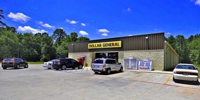

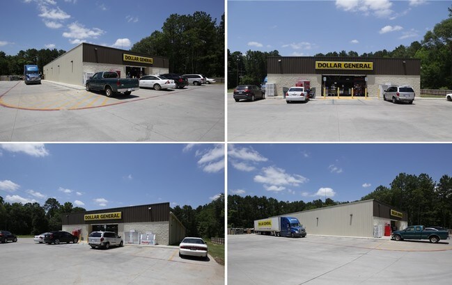
Property Detail
15277 N Tram Rd
8700-00-04940
S870000 - SHADY DALE LOT 47-B, 47B-1 (SPLENDORA DTP ADDITION # 2016077597, BLOCK 1, RES A), ACRES 1.707
Commercialnec
Montgomery
5
Texas
B and X Area of moderate flood hazard, usually the area between the limits of the 100-year and 500-year floods.
47-b
2024
1.71 AC
2025
Montgomery County
692803
Houston
9,100 SF
Houston-Pasadena-The Woodlands, TX
NEARBY LISTINGS FOR SALE OR LEASE
DEMOGRAPHICS near 15277 N Tram Rd
1 mile
3 mile
5 mile
2025 Total Population
2,068
14,965
44,224
2030 Population
2,433
17,723
53,004
Pop Growth 2025-2030
+ 17.65%
+ 18.43%
+ 19.85%
Average Age
38
37
35
2025 Total Households
679
4,859
13,651
HH Growth 2025-2030
+ 18.11%
+ 18.81%
+ 20.12%
Median Household Inc
$75,086
$80,703
$79,280
Avg Household Size
3.00
3.00
3.20
2025 Avg HH Vehicles
2.00
2.00
2.00
Median Home Value
$302,367
$271,836
$258,021
Median Year Built
2001
2000
2004
Nearby Places
Map Layers
Map Styles
 Street
 Aerial
Layers
 Traffic
 Biking
Places
Listings with unknown addresses are not visible on the map
- Restaurants
- Banks
- Shops
- Fitness
- Groceries
PUBLIC TRANSPORTATION
AIRPORT
George Bush Intcntl/Houston
Drive
Walk
Distance
George Bush Intcntl/Houston
35 min
27.7 mi
Freight Ports
Port of Houston
Drive
Walk
Distance
Port of Houston
56 min
43.0 mi
SALE & LEASE HISTORY
LISTING DATE
SALE/LEASE

Jun 12, 2018
For Sale
Nearby Properties
Address
Land Use
TOTAL SIZE
Lot Size
Zoning
Address
Land Use
TOTAL SIZE
Lot Size
Zoning
84,249 SF
38.34 AC
Address
Land Use
TOTAL SIZE
Lot Size
Zoning
97,193 SF
24.79 AC
5
Address
Land Use
TOTAL SIZE
Lot Size
Zoning
78,721 SF
22.26 AC
Address
Land Use
TOTAL SIZE
Lot Size
Zoning
26,348 SF
30.22 AC
5
Address
Land Use
TOTAL SIZE
Lot Size
Zoning
84,704 SF
4.47 AC
5
Address
Land Use
TOTAL SIZE
Lot Size
Zoning
30,916 SF
3.36 AC
Address
Land Use
TOTAL SIZE
Lot Size
Zoning
3,880 SF
13.32 AC
5
Address
Land Use
TOTAL SIZE
Lot Size
Zoning
19,684 SF
7.90 AC
5
Address
Land Use
TOTAL SIZE
Lot Size
Zoning
58,972 SF
4.70 AC
5
Address
Land Use
TOTAL SIZE
Lot Size
Zoning
10,792 SF
2.70 AC
Address
Land Use
TOTAL SIZE
Lot Size
Zoning
237 SF
10.51 AC
5
Address
Land Use
TOTAL SIZE
Lot Size
Zoning
19,587 SF
3.50 AC
Address
Land Use
TOTAL SIZE
Lot Size
Zoning
10,640 SF
1.13 AC
Address
Land Use
TOTAL SIZE
Lot Size
Zoning
7,000 SF
4.51 AC
Address
Land Use
TOTAL SIZE
Lot Size
Zoning
36,490 SF
2.72 AC
5
Address
Land Use
TOTAL SIZE
Lot Size
Zoning
21,513 SF
5.52 AC
5
Address
Land Use
TOTAL SIZE
Lot Size
Zoning
6,193 SF
4.84 AC
5
Address
Land Use
TOTAL SIZE
Lot Size
Zoning
9,100 SF
1.18 AC
5
Address
Land Use
TOTAL SIZE
Lot Size
Zoning
49.40 AC
5
Address
Land Use
TOTAL SIZE
Lot Size
Zoning
7,740 SF
1.32 AC
5
Address
Land Use
TOTAL SIZE
Lot Size
Zoning
22,000 SF
3.01 AC
5
Address
Land Use
TOTAL SIZE
Lot Size
Zoning
28,572 SF
3.58 AC
5
Address
Land Use
TOTAL SIZE
Lot Size
Zoning
2,049 SF
5 AC
5
Address
Land Use
TOTAL SIZE
Lot Size
Zoning
21,025 SF
3.11 AC
Address
Land Use
TOTAL SIZE
Lot Size
Zoning
22,232 SF
4.53 AC
Address
Land Use
TOTAL SIZE
Lot Size
Zoning
9,261 SF
1.91 AC
Address
Land Use
TOTAL SIZE
Lot Size
Zoning
2,250 SF
7 AC
5
Address
Land Use
TOTAL SIZE
Lot Size
Zoning
13,760 SF
2.03 AC
5
The World's #1 Commercial Real Estate Marketplace
Connect with us
© 2026 CoStar Group
The information above has been obtained from sources believed reliable. While we do not doubt its accuracy we have not verified it and make no guarantee, warranty or representation about it. It is your responsibility to independently confirm its accuracy and completeness. Any projections, opinions, assumptions, or estimates used are for example only and do not represent the current or future performance of the property. The value of this transaction to you depends on tax and other factors which should be evaluated by your tax, financial, and legal advisors. You and your advisors should conduct a careful, independent investigation of the property to determine to your satisfaction the suitability of the property for your needs.