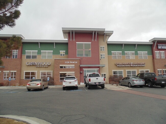
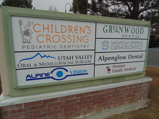
Property Record
1528 N Commerce Dr, Saratoga Springs, UT 84045

This Property Is For Sale
NEARBY LISTINGS FOR SALE OR LEASE
Property Detail
1528 N Commerce Dr
Provo-Orem-Lehi, UT
Saratoga Town Center Office Condos
66-320-0204
UNIT 204, PLAT B, SARATOGA TOWN CENTER OFFICE CONDOS. AREA 0.047 AC.
Medicalbuilding
Utah
2024
Utah
2025
0.05 AC
010124
Utah County
2,044 SF
Salt Lake City
DEMOGRAPHICS near 1528 N Commerce Dr
1 Mile
3 Mile
5 Mile
2024 Total Population
13,222
61,983
157,015
2029 Population
15,724
73,516
185,340
Pop Growth 2024-2029
+ 18.92%
+ 18.61%
+ 18.04%
Average Age
27
28
28
2024 Total Households
3,748
16,521
41,042
HH Growth 2024-2029
+ 19.45%
+ 19.10%
+ 18.52%
Median Household Inc
$108,675
$112,660
$111,847
Avg Household Size
3.50
3.70
3.80
2024 Avg HH Vehicles
2.00
2.00
2.00
Median Home Value
$447,329
$473,722
$489,014
Median Year Built
2010
2010
2010
Nearby Places
Map Layers
Map Styles
 Street
 Aerial
- Restaurants
- Banks
- Shops
- Fitness
- Groceries
PUBLIC TRANSPORTATION
COMMUTER RAIL
Lehi Station (FrontRunner - Utah Transit Authority (UTA))
DRIVE
WALK
Distance
Lehi Station (FrontRunner - Utah Transit Authority (UTA))
9 min
4.7 mi
American Fork Station (FrontRunner - Utah Transit Authority (UTA))
DRIVE
WALK
Distance
American Fork Station (FrontRunner - Utah Transit Authority (UTA))
13 min
7.1 mi
AIRPORT
Provo Municipal
DRIVE
WALK
Distance
Provo Municipal
32 min
22.7 mi
Salt Lake City International
DRIVE
WALK
Distance
Salt Lake City International
42 min
34.3 mi
Freight Ports
Port of Stockton
DRIVE
WALK
Distance
Port of Stockton
738 min
712.0 mi
Nearby Properties
Address
Land Use
TOTAL SIZE
Lot Size
Zoning
Address
Land Use
TOTAL SIZE
Lot Size
Zoning
36.17 AC
Address
Land Use
TOTAL SIZE
Lot Size
Zoning
166,233 SF
8.70 AC
Address
Land Use
TOTAL SIZE
Lot Size
Zoning
131,961 SF
7.57 AC
Address
Land Use
TOTAL SIZE
Lot Size
Zoning
247,594 SF
19.01 AC
Address
Land Use
TOTAL SIZE
Lot Size
Zoning
216,478 SF
7.38 AC
Address
Land Use
TOTAL SIZE
Lot Size
Zoning
255,672 SF
6.21 AC
Address
Land Use
TOTAL SIZE
Lot Size
Zoning
215,516 SF
4.93 AC
Address
Land Use
TOTAL SIZE
Lot Size
Zoning
181,908 SF
1.43 AC
Address
Land Use
TOTAL SIZE
Lot Size
Zoning
147,368 SF
6.91 AC
Address
Land Use
TOTAL SIZE
Lot Size
Zoning
139,088 SF
9.14 AC
Address
Land Use
TOTAL SIZE
Lot Size
Zoning
149,591 SF
7.07 AC
Address
Land Use
TOTAL SIZE
Lot Size
Zoning
253,421 SF
7.36 AC
Address
Land Use
TOTAL SIZE
Lot Size
Zoning
293,170 SF
9.60 AC
Address
Land Use
TOTAL SIZE
Lot Size
Zoning
255,672 SF
2.94 AC
Address
Land Use
TOTAL SIZE
Lot Size
Zoning
9.80 AC
Address
Land Use
TOTAL SIZE
Lot Size
Zoning
266,041 SF
11.28 AC
Address
Land Use
TOTAL SIZE
Lot Size
Zoning
142,042 SF
6.99 AC
Address
Land Use
TOTAL SIZE
Lot Size
Zoning
142,299 SF
6.99 AC
Address
Land Use
TOTAL SIZE
Lot Size
Zoning
150,068 SF
5.05 AC
Address
Land Use
TOTAL SIZE
Lot Size
Zoning
143,199 SF
5.83 AC
Address
Land Use
TOTAL SIZE
Lot Size
Zoning
146,675 SF
1.09 AC
Address
Land Use
TOTAL SIZE
Lot Size
Zoning
61,537 SF
3 AC
Address
Land Use
TOTAL SIZE
Lot Size
Zoning
127,744 SF
6 AC
Address
Land Use
TOTAL SIZE
Lot Size
Zoning
98,726 SF
2.85 AC
Address
Land Use
TOTAL SIZE
Lot Size
Zoning
198,068 SF
20.72 AC
Address
Land Use
TOTAL SIZE
Lot Size
Zoning
159,119 SF
8.47 AC
Address
Land Use
TOTAL SIZE
Lot Size
Zoning
123,381 SF
12.30 AC
Address
Land Use
TOTAL SIZE
Lot Size
Zoning
134,637 SF
16.98 AC
Address
Land Use
TOTAL SIZE
Lot Size
Zoning
99,862 SF
10.92 AC
Address
Land Use
TOTAL SIZE
Lot Size
Zoning
67,290 SF
5.05 AC
The World's #1 Commercial Real Estate Marketplace
Connect with us
© 2026 CoStar Group
The information above has been obtained from sources believed reliable. While we do not doubt its accuracy we have not verified it and make no guarantee, warranty or representation about it. It is your responsibility to independently confirm its accuracy and completeness. Any projections, opinions, assumptions, or estimates used are for example only and do not represent the current or future performance of the property. The value of this transaction to you depends on tax and other factors which should be evaluated by your tax, financial, and legal advisors. You and your advisors should conduct a careful, independent investigation of the property to determine to your satisfaction the suitability of the property for your needs.