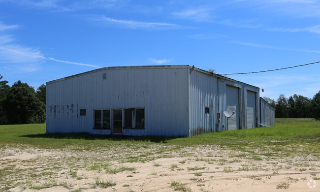
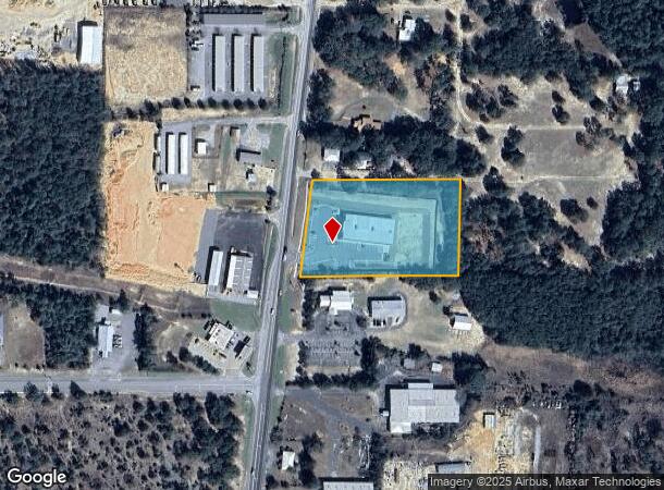
Property Record
1528 State Highway 83, Defuniak Springs, FL 32433
NEARBY LISTINGS FOR SALE OR LEASE
Property Detail
1528 State Highway 83
Crestview-Fort Walton Beach-Destin, FL
R E L Mccaskill S/D
23-3N-19-19000-003-0010
THE W 250FT OF THE S 298.87FT OF THE N1/2 OF THE S1/2 OF THE SW1/4 OF THE NE1/4 AND THAT PART OF THE S 298.87FT OF THE N1/2 OF S1/2 OF SE1/4 OF NW1/4 LYING E OF ST RD #83 IN SEC 23-3N-19W OR 84-304 OR 834-150 OR 2695-2981 OR 2695-4543 OR 2783-646 OR
Storemultistory
Walton
X
Florida
12131C0280G
10
2025
3.49 AC
2025
Florida Panhandle Area
950202
Other Market Areas
12,951 SF
DEMOGRAPHICS near 1528 State Highway 83
1 Mile
3 Mile
5 Mile
2024 Total Population
774
8,712
11,972
2029 Population
935
10,441
14,369
Pop Growth 2024-2029
+ 20.80%
+ 19.85%
+ 20.02%
Average Age
39
39
39
2024 Total Households
202
2,760
3,847
HH Growth 2024-2029
+ 21.29%
+ 19.78%
+ 19.99%
Median Household Inc
$61,250
$39,554
$40,808
Avg Household Size
2.40
2.50
2.50
2024 Avg HH Vehicles
2.00
2.00
2.00
Median Home Value
$92,063
$92,364
$93,423
Median Year Built
1990
1988
1990
Nearby Places
- Restaurants
- Banks
- Shops
- Fitness
- Groceries
SALE & LEASE HISTORY
LISTING DATE
SALE/LEASE

Feb 22, 2017
For Sale
Nearby Properties
Address
Land Use
TOTAL SIZE
Lot Size
Zoning
Address
Land Use
TOTAL SIZE
Lot Size
Zoning
461,058 SF
45.55 AC
Address
Land Use
TOTAL SIZE
Lot Size
Zoning
174,929 SF
9.32 AC
HD1
Address
Land Use
TOTAL SIZE
Lot Size
Zoning
126,838 SF
27.27 AC
Address
Land Use
TOTAL SIZE
Lot Size
Zoning
167,839 SF
40 AC
Address
Land Use
TOTAL SIZE
Lot Size
Zoning
96,057 SF
10.37 AC
W END
Address
Land Use
TOTAL SIZE
Lot Size
Zoning
54,534 SF
7.33 AC
MUNI
Address
Land Use
TOTAL SIZE
Lot Size
Zoning
209,007 SF
245.09 AC
Address
Land Use
TOTAL SIZE
Lot Size
Zoning
160,339 SF
19.76 AC
3310
Address
Land Use
TOTAL SIZE
Lot Size
Zoning
81,976 SF
315 AC
Address
Land Use
TOTAL SIZE
Lot Size
Zoning
37,731 SF
15.96 AC
Address
Land Use
TOTAL SIZE
Lot Size
Zoning
53,201 SF
14.45 AC
Address
Land Use
TOTAL SIZE
Lot Size
Zoning
101,840 SF
11.04 AC
3310
Address
Land Use
TOTAL SIZE
Lot Size
Zoning
10,655 SF
163.72 AC
MUNI
Address
Land Use
TOTAL SIZE
Lot Size
Zoning
109,921 SF
2.25 AC
Address
Land Use
TOTAL SIZE
Lot Size
Zoning
68,153 SF
9.65 AC
3310
Address
Land Use
TOTAL SIZE
Lot Size
Zoning
44,789 SF
4.34 AC
Address
Land Use
TOTAL SIZE
Lot Size
Zoning
15,264 SF
3.24 AC
3310
Address
Land Use
TOTAL SIZE
Lot Size
Zoning
48,394 SF
8.79 AC
3310
Address
Land Use
TOTAL SIZE
Lot Size
Zoning
104,680 SF
10 AC
Address
Land Use
TOTAL SIZE
Lot Size
Zoning
32,375 SF
6.46 AC
HWY90
Address
Land Use
TOTAL SIZE
Lot Size
Zoning
3,987 SF
104.01 AC
LKJUNP
Address
Land Use
TOTAL SIZE
Lot Size
Zoning
17,310 SF
13.26 AC
3310
Address
Land Use
TOTAL SIZE
Lot Size
Zoning
35,967 SF
4.11 AC
Address
Land Use
TOTAL SIZE
Lot Size
Zoning
14,525 SF
0.90 AC
HWY90
Address
Land Use
TOTAL SIZE
Lot Size
Zoning
17,376 SF
79.90 AC
HD1
Address
Land Use
TOTAL SIZE
Lot Size
Zoning
40,583 SF
2 AC
Address
Land Use
TOTAL SIZE
Lot Size
Zoning
24,662 SF
2.04 AC
Address
Land Use
TOTAL SIZE
Lot Size
Zoning
35,050 SF
3.98 AC
MUNI
Address
Land Use
TOTAL SIZE
Lot Size
Zoning
37,138 SF
8.10 AC
HWY90
Address
Land Use
TOTAL SIZE
Lot Size
Zoning
102,162 SF
24.05 AC
The World's #1 Commercial Real Estate Marketplace
Connect with us
© 2025 CoStar Group
The information above has been obtained from sources believed reliable. While we do not doubt its accuracy we have not verified it and make no guarantee, warranty or representation about it. It is your responsibility to independently confirm its accuracy and completeness. Any projections, opinions, assumptions, or estimates used are for example only and do not represent the current or future performance of the property. The value of this transaction to you depends on tax and other factors which should be evaluated by your tax, financial, and legal advisors. You and your advisors should conduct a careful, independent investigation of the property to determine to your satisfaction the suitability of the property for your needs.