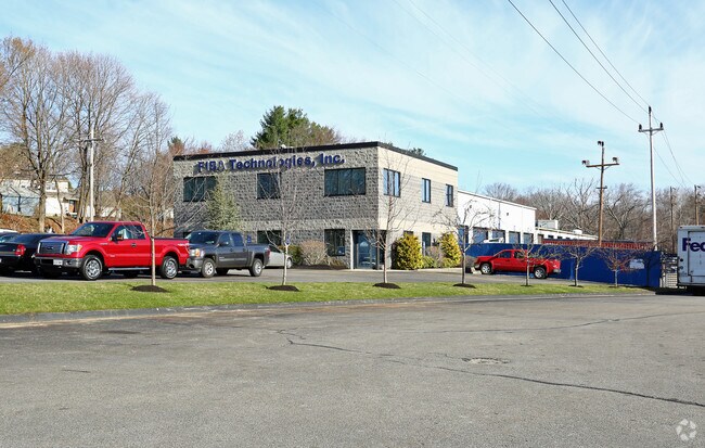
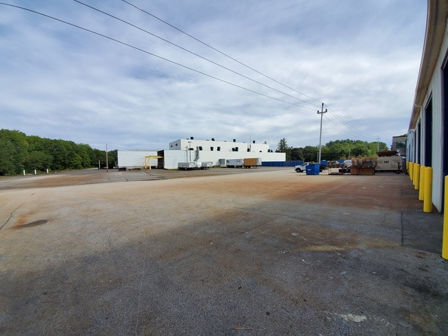
Property Record
1537 Grafton Rd, Millbury, MA 01527

NEARBY LISTINGS FOR SALE OR LEASE
Property Detail
1537 Grafton Rd
Manufacturinglight
Worcester
X
Massachusetts
25027C0826E
5.70 AC
2025
Worcester Metro
2025
Boston
737300
Worcester, MA-CT
44,646 SF
MILB-000007-000000-000017
DEMOGRAPHICS near 1537 Grafton Rd
1 Mile
3 Mile
5 Mile
2024 Total Population
5,136
52,210
189,955
2029 Population
5,118
52,081
188,417
Pop Growth 2024-2029
(0.35%)
(0.25%)
(0.81%)
Average Age
42
41
38
2024 Total Households
2,022
21,137
73,819
HH Growth 2024-2029
(0.40%)
(0.20%)
(0.77%)
Median Household Inc
$106,141
$87,099
$69,984
Avg Household Size
2.50
2.40
2.40
2024 Avg HH Vehicles
2.00
2.00
2.00
Median Home Value
$390,475
$364,037
$375,577
Median Year Built
1973
1968
1959
Nearby Places
Map Layers
Map Styles
 Street
 Aerial
- Restaurants
- Banks
- Shops
- Fitness
- Groceries
PUBLIC TRANSPORTATION
COMMUTER RAIL
Grafton (Framingham/Worcester Line - Massachusetts Bay Transportation Authority Commuter Rail (Purple Line))
DRIVE
WALK
Distance
Grafton (Framingham/Worcester Line - Massachusetts Bay Transportation Authority Commuter Rail (Purple Line))
8 min
3.6 mi
DRIVE
WALK
Distance
8 min
4.5 mi
AIRPORT
Worcester Regional
DRIVE
WALK
Distance
Worcester Regional
20 min
10.3 mi
SALE & LEASE HISTORY
LISTING DATE
SALE/LEASE

Oct 02, 2019
For Lease
Jun 04, 2018
For Lease
Nearby Properties
Address
Land Use
TOTAL SIZE
Lot Size
Zoning
Address
Land Use
TOTAL SIZE
Lot Size
Zoning
46.50 AC
R4
Address
Land Use
TOTAL SIZE
Lot Size
Zoning
43.07 AC
COM BU
Address
Land Use
TOTAL SIZE
Lot Size
Zoning
176,316 SF
19.57 AC
RL-7
Address
Land Use
TOTAL SIZE
Lot Size
Zoning
70,514 SF
31.64 AC
RL-7
Address
Land Use
TOTAL SIZE
Lot Size
Zoning
591,515 SF
33.04 AC
MG-1
Address
Land Use
TOTAL SIZE
Lot Size
Zoning
210,168 SF
45.75 AC
RL-7
Address
Land Use
TOTAL SIZE
Lot Size
Zoning
203,184 SF
0.21 AC
MF-1
Address
Land Use
TOTAL SIZE
Lot Size
Zoning
27.89 AC
RL-7
Address
Land Use
TOTAL SIZE
Lot Size
Zoning
64.46 AC
RS-7
Address
Land Use
TOTAL SIZE
Lot Size
Zoning
78.19 AC
RL-7
Address
Land Use
TOTAL SIZE
Lot Size
Zoning
7,700 SF
80.72 AC
ML-.5
Address
Land Use
TOTAL SIZE
Lot Size
Zoning
134,896 SF
15.10 AC
LIM IN
Address
Land Use
TOTAL SIZE
Lot Size
Zoning
53.52 AC
RL-7
Address
Land Use
TOTAL SIZE
Lot Size
Zoning
222,474 SF
22.75 AC
MG-1
Address
Land Use
TOTAL SIZE
Lot Size
Zoning
93,092 SF
162.83 AC
OLI
Address
Land Use
TOTAL SIZE
Lot Size
Zoning
55.79 AC
R4
Address
Land Use
TOTAL SIZE
Lot Size
Zoning
40.46 AC
R4
Address
Land Use
TOTAL SIZE
Lot Size
Zoning
133,482 SF
15.80 AC
BG-2
Address
Land Use
TOTAL SIZE
Lot Size
Zoning
18.10 AC
I1
Address
Land Use
TOTAL SIZE
Lot Size
Zoning
115,564 SF
9.33 AC
RL-7
Address
Land Use
TOTAL SIZE
Lot Size
Zoning
Address
Land Use
TOTAL SIZE
Lot Size
Zoning
19.76 AC
BL-1
Address
Land Use
TOTAL SIZE
Lot Size
Zoning
57,288 SF
11.95 AC
CB
Address
Land Use
TOTAL SIZE
Lot Size
Zoning
47.94 AC
RL-7
Address
Land Use
TOTAL SIZE
Lot Size
Zoning
84,672 SF
17.85 AC
COM BU
Address
Land Use
TOTAL SIZE
Lot Size
Zoning
1,628 SF
7.06 AC
Address
Land Use
TOTAL SIZE
Lot Size
Zoning
71,622 SF
33.28 AC
Address
Land Use
TOTAL SIZE
Lot Size
Zoning
90,183 SF
0.86 AC
RG-5
Address
Land Use
TOTAL SIZE
Lot Size
Zoning
96,000 SF
Address
Land Use
TOTAL SIZE
Lot Size
Zoning
103,460 SF
8.41 AC
I2
The World's #1 Commercial Real Estate Marketplace
Connect with us
© 2025 CoStar Group
The information above has been obtained from sources believed reliable. While we do not doubt its accuracy we have not verified it and make no guarantee, warranty or representation about it. It is your responsibility to independently confirm its accuracy and completeness. Any projections, opinions, assumptions, or estimates used are for example only and do not represent the current or future performance of the property. The value of this transaction to you depends on tax and other factors which should be evaluated by your tax, financial, and legal advisors. You and your advisors should conduct a careful, independent investigation of the property to determine to your satisfaction the suitability of the property for your needs.