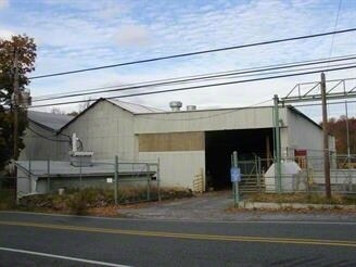
Property Record
1529 Manatawny Dr, Boyertown, PA 19512

NEARBY LISTINGS FOR SALE OR LEASE
Property Detail
1529 Manatawny Dr
41-5375-04-52-3327
Berks
Warehouse
Pennsylvania
AE
2
42091C0066G
9.85 AC
2025
Berks
2025
Philadelphia
013100
Reading, PA
35,851 SF
DEMOGRAPHICS near 1529 Manatawny Dr
1 Mile
3 Mile
5 Mile
2024 Total Population
690
26,484
79,997
2029 Population
694
26,632
80,948
Pop Growth 2024-2029
+ 0.58%
+ 0.56%
+ 1.19%
Average Age
47
41
41
2024 Total Households
287
10,284
31,234
HH Growth 2024-2029
+ 0.70%
+ 0.57%
+ 1.21%
Median Household Inc
$64,333
$70,935
$74,846
Avg Household Size
2.30
2.50
2.50
2024 Avg HH Vehicles
2.00
2.00
2.00
Median Home Value
$228,090
$222,825
$237,900
Median Year Built
1959
1970
1966
Nearby Places
Map Layers
Map Styles
 Street
 Aerial
- Restaurants
- Banks
- Shops
- Fitness
- Groceries
PUBLIC TRANSPORTATION
AIRPORT
Lehigh Valley International
DRIVE
WALK
Distance
Lehigh Valley International
63 min
34.0 mi
Freight Ports
Port of Philadelphia
DRIVE
WALK
Distance
Port of Philadelphia
74 min
48.9 mi
SALE & LEASE HISTORY
LISTING DATE
SALE/LEASE

Sep 25, 2016
For Lease
Aug 24, 2023
For Lease
Nearby Properties
Address
Land Use
TOTAL SIZE
Lot Size
Zoning
Address
Land Use
TOTAL SIZE
Lot Size
Zoning
406,166 SF
65.54 AC
C
Address
Land Use
TOTAL SIZE
Lot Size
Zoning
172,766 SF
43.12 AC
R3
Address
Land Use
TOTAL SIZE
Lot Size
Zoning
150,711 SF
21.72 AC
HB
Address
Land Use
TOTAL SIZE
Lot Size
Zoning
176,741 SF
17.40 AC
HB
Address
Land Use
TOTAL SIZE
Lot Size
Zoning
138,563 SF
12.98 AC
C
Address
Land Use
TOTAL SIZE
Lot Size
Zoning
114,995 SF
4.30 AC
Address
Land Use
TOTAL SIZE
Lot Size
Zoning
80,236 SF
3.78 AC
Address
Land Use
TOTAL SIZE
Lot Size
Zoning
290,108 SF
23 AC
Address
Land Use
TOTAL SIZE
Lot Size
Zoning
175,151 SF
14.74 AC
RMHD
Address
Land Use
TOTAL SIZE
Lot Size
Zoning
186,504 SF
24.23 AC
Address
Land Use
TOTAL SIZE
Lot Size
Zoning
61,031 SF
14.54 AC
R3
Address
Land Use
TOTAL SIZE
Lot Size
Zoning
45,138 SF
9.13 AC
C
Address
Land Use
TOTAL SIZE
Lot Size
Zoning
56,774 SF
1.58 AC
C
Address
Land Use
TOTAL SIZE
Lot Size
Zoning
48,772 SF
6.17 AC
Address
Land Use
TOTAL SIZE
Lot Size
Zoning
31,680 SF
7.48 AC
R3
Address
Land Use
TOTAL SIZE
Lot Size
Zoning
63,523 SF
4 AC
FO
Address
Land Use
TOTAL SIZE
Lot Size
Zoning
81,285 SF
0.67 AC
D
Address
Land Use
TOTAL SIZE
Lot Size
Zoning
54,030 SF
6.25 AC
NR
Address
Land Use
TOTAL SIZE
Lot Size
Zoning
35,248 SF
4.28 AC
HB
Address
Land Use
TOTAL SIZE
Lot Size
Zoning
59,400 SF
2.20 AC
HB
Address
Land Use
TOTAL SIZE
Lot Size
Zoning
67,850 SF
3.60 AC
RMD
Address
Land Use
TOTAL SIZE
Lot Size
Zoning
74,056 SF
6.91 AC
Address
Land Use
TOTAL SIZE
Lot Size
Zoning
45,198 SF
249.72 AC
Address
Land Use
TOTAL SIZE
Lot Size
Zoning
41,448 SF
10.31 AC
RMHD
Address
Land Use
TOTAL SIZE
Lot Size
Zoning
47,800 SF
9.07 AC
Address
Land Use
TOTAL SIZE
Lot Size
Zoning
44,051 SF
62.77 AC
FO
Address
Land Use
TOTAL SIZE
Lot Size
Zoning
71,362 SF
3.81 AC
RMHD
Address
Land Use
TOTAL SIZE
Lot Size
Zoning
34,180 SF
8.78 AC
Address
Land Use
TOTAL SIZE
Lot Size
Zoning
72,704 SF
7.39 AC
FO
Address
Land Use
TOTAL SIZE
Lot Size
Zoning
47,580 SF
1.52 AC
R4
The World's #1 Commercial Real Estate Marketplace
Connect with us
© 2026 CoStar Group
The information above has been obtained from sources believed reliable. While we do not doubt its accuracy we have not verified it and make no guarantee, warranty or representation about it. It is your responsibility to independently confirm its accuracy and completeness. Any projections, opinions, assumptions, or estimates used are for example only and do not represent the current or future performance of the property. The value of this transaction to you depends on tax and other factors which should be evaluated by your tax, financial, and legal advisors. You and your advisors should conduct a careful, independent investigation of the property to determine to your satisfaction the suitability of the property for your needs.