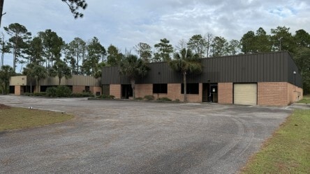
Property Record
153 Anderson Rd, Walterboro, SC 29488

NEARBY LISTINGS FOR SALE OR LEASE
Property Detail
153 Anderson Rd
132-00-00-119
Colleton
Commercialnec
South Carolina
X
5.10 AC
45029C0330G
I-95 Walterboro/Hardeeville
22,080 SF
Other Market Areas
DEMOGRAPHICS near 153 Anderson Rd
1 Mile
3 Mile
5 Mile
2024 Total Population
1,028
5,052
15,003
2029 Population
1,018
4,995
14,852
Pop Growth 2024-2029
(0.97%)
(1.13%)
(1.01%)
Average Age
40
41
41
2024 Total Households
364
1,898
5,928
HH Growth 2024-2029
(1.10%)
(1.21%)
(1.15%)
Median Household Inc
$32,840
$42,361
$42,264
Avg Household Size
2.50
2.50
2.40
2024 Avg HH Vehicles
2.00
2.00
2.00
Median Home Value
$64,722
$86,959
$95,193
Median Year Built
1992
1990
1983
Nearby Places
Map Layers
Map Styles
 Street
 Aerial
- Restaurants
- Banks
- Shops
- Fitness
- Groceries
PUBLIC TRANSPORTATION
AIRPORT
Charleston AFB/International
DRIVE
WALK
Distance
Charleston AFB/International
60 min
39.1 mi
Freight Ports
North Charleston Terminal
DRIVE
WALK
Distance
North Charleston Terminal
68 min
44.0 mi
SALE & LEASE HISTORY
LISTING DATE
SALE/LEASE

Sep 18, 2024
For Sale
May 01, 2023
For Sale
Feb 25, 2022
For Sale
Apr 11, 2023
For Sale
Nearby Properties
Address
Land Use
TOTAL SIZE
Lot Size
Zoning
Address
Land Use
TOTAL SIZE
Lot Size
Zoning
200,549 SF
2.90 AC
Address
Land Use
TOTAL SIZE
Lot Size
Zoning
3,273 SF
1,539 AC
ID
Address
Land Use
TOTAL SIZE
Lot Size
Zoning
206,250 SF
33.20 AC
ID
Address
Land Use
TOTAL SIZE
Lot Size
Zoning
22,758 SF
3 AC
Address
Land Use
TOTAL SIZE
Lot Size
Zoning
86,169 SF
9 AC
UD
Address
Land Use
TOTAL SIZE
Lot Size
Zoning
17,460 SF
8.30 AC
Address
Land Use
TOTAL SIZE
Lot Size
Zoning
5,345 SF
1.30 AC
Address
Land Use
TOTAL SIZE
Lot Size
Zoning
61,430 SF
8.80 AC
Address
Land Use
TOTAL SIZE
Lot Size
Zoning
138,213 SF
43.30 AC
Address
Land Use
TOTAL SIZE
Lot Size
Zoning
47,410 SF
10.90 AC
ID
Address
Land Use
TOTAL SIZE
Lot Size
Zoning
10.40 AC
Address
Land Use
TOTAL SIZE
Lot Size
Zoning
110 AC
UD
Address
Land Use
TOTAL SIZE
Lot Size
Zoning
3,000 SF
1.30 AC
Address
Land Use
TOTAL SIZE
Lot Size
Zoning
116.60 AC
Address
Land Use
TOTAL SIZE
Lot Size
Zoning
1,536 SF
9.10 AC
UD
Address
Land Use
TOTAL SIZE
Lot Size
Zoning
1,054 SF
1.50 AC
Address
Land Use
TOTAL SIZE
Lot Size
Zoning
9,577 SF
6.40 AC
UD
Address
Land Use
TOTAL SIZE
Lot Size
Zoning
45,683 SF
11.30 AC
ID
Address
Land Use
TOTAL SIZE
Lot Size
Zoning
59,764 SF
25.20 AC
ID
Address
Land Use
TOTAL SIZE
Lot Size
Zoning
Address
Land Use
TOTAL SIZE
Lot Size
Zoning
30,000 SF
7.70 AC
ID
Address
Land Use
TOTAL SIZE
Lot Size
Zoning
77,253 SF
12.20 AC
Address
Land Use
TOTAL SIZE
Lot Size
Zoning
10,414 SF
11.80 AC
UD
Address
Land Use
TOTAL SIZE
Lot Size
Zoning
13,150 SF
12 AC
ID
Address
Land Use
TOTAL SIZE
Lot Size
Zoning
17,077 SF
7.50 AC
ID
Address
Land Use
TOTAL SIZE
Lot Size
Zoning
5.16 AC
CC
Address
Land Use
TOTAL SIZE
Lot Size
Zoning
7,000 SF
6.80 AC
UD
Address
Land Use
TOTAL SIZE
Lot Size
Zoning
9,239 SF
17.40 AC
UD
Address
Land Use
TOTAL SIZE
Lot Size
Zoning
4,800 SF
23.80 AC
UD
The World's #1 Commercial Real Estate Marketplace
Connect with us
© 2025 CoStar Group
The information above has been obtained from sources believed reliable. While we do not doubt its accuracy we have not verified it and make no guarantee, warranty or representation about it. It is your responsibility to independently confirm its accuracy and completeness. Any projections, opinions, assumptions, or estimates used are for example only and do not represent the current or future performance of the property. The value of this transaction to you depends on tax and other factors which should be evaluated by your tax, financial, and legal advisors. You and your advisors should conduct a careful, independent investigation of the property to determine to your satisfaction the suitability of the property for your needs.