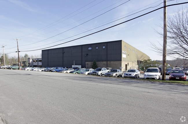
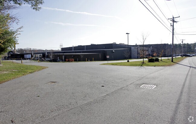
Property Record
1530 Broadway Rd, Dracut, MA 01826

Save to a Folder
{{folder.Name}}
{{folder.ListingIds.length}} Properties
{{folder.ListingIds.length}} Property
Create a New Folder
Property Detail
1530 Broadway Rd
DRAC-000008-000019-000019
Middlesex
Warehouse
Massachusetts
B
19
A Areas with a 1% annual chance of flooding and a 26% chance of flooding over the life of a 30-year mortgage.
11 AC
2025
Groton/Townsend
2025
Boston
314302
Boston-Cambridge-Newton, MA-NH
159,299 SF
NEARBY LISTINGS FOR SALE OR LEASE
DEMOGRAPHICS near 1530 Broadway Rd
1 mile
3 mile
5 mile
2025 Total Population
1,820
30,746
186,760
2030 Population
1,902
31,635
189,497
Pop Growth 2025-2030
+ 4.51%
+ 2.89%
+ 1.47%
Average Age
41
42
39
2025 Total Households
583
10,899
66,215
HH Growth 2025-2030
+ 4.46%
+ 2.79%
+ 1.65%
Median Household Inc
$149,297
$122,660
$81,152
Avg Household Size
3.10
2.80
2.70
2025 Avg HH Vehicles
3.00
2.00
2.00
Median Home Value
$677,419
$609,539
$497,400
Median Year Built
1984
1974
1962
Nearby Places
Map Layers
Map Styles
 Street
 Aerial
Layers
 Traffic
 Biking
Places
Listings with unknown addresses are not visible on the map
- Restaurants
- Banks
- Shops
- Fitness
- Groceries
PUBLIC TRANSPORTATION
COMMUTER RAIL
Lawrence (Haverhill Line - Massachusetts Bay Transportation Authority Commuter Rail (Purple Line))
Drive
Walk
Distance
Lawrence (Haverhill Line - Massachusetts Bay Transportation Authority Commuter Rail (Purple Line))
13 min
6.2 mi
Lowell (Lowell Line - Massachusetts Bay Transportation Authority Commuter Rail (Purple Line))
Drive
Walk
Distance
Lowell (Lowell Line - Massachusetts Bay Transportation Authority Commuter Rail (Purple Line))
15 min
6.7 mi
AIRPORT
Manchester Boston Regional
Drive
Walk
Distance
Manchester Boston Regional
43 min
27.2 mi
General Edward Lawrence Logan International
Drive
Walk
Distance
General Edward Lawrence Logan International
43 min
30.9 mi
Portsmouth International at Pease
Drive
Walk
Distance
Portsmouth International at Pease
59 min
42.4 mi
Nearby Properties
Address
Land Use
TOTAL SIZE
Lot Size
Zoning
Address
Land Use
TOTAL SIZE
Lot Size
Zoning
10.40 AC
ID
Address
Land Use
TOTAL SIZE
Lot Size
Zoning
61.83 AC
ID2
Address
Land Use
TOTAL SIZE
Lot Size
Zoning
24 AC
ID
Address
Land Use
TOTAL SIZE
Lot Size
Zoning
382,817 SF
25.86 AC
ID2
Address
Land Use
TOTAL SIZE
Lot Size
Zoning
803 SF
3.29 AC
R1
Address
Land Use
TOTAL SIZE
Lot Size
Zoning
48.33 AC
ID
Address
Land Use
TOTAL SIZE
Lot Size
Zoning
210,192 SF
15.06 AC
CN
Address
Land Use
TOTAL SIZE
Lot Size
Zoning
196,152 SF
20.20 AC
ID2
Address
Land Use
TOTAL SIZE
Lot Size
Zoning
43.36 AC
ID2
Address
Land Use
TOTAL SIZE
Lot Size
Zoning
322,858 SF
15.97 AC
ID
Address
Land Use
TOTAL SIZE
Lot Size
Zoning
162,978 SF
13.73 AC
ID2
Address
Land Use
TOTAL SIZE
Lot Size
Zoning
150,292 SF
22.77 AC
ID2
Address
Land Use
TOTAL SIZE
Lot Size
Zoning
105,949 SF
28.24 AC
ID2
Address
Land Use
TOTAL SIZE
Lot Size
Zoning
5.43 AC
ID
Address
Land Use
TOTAL SIZE
Lot Size
Zoning
234,000 SF
17.55 AC
IL
Address
Land Use
TOTAL SIZE
Lot Size
Zoning
127,448 SF
13.14 AC
ID
Address
Land Use
TOTAL SIZE
Lot Size
Zoning
124,760 SF
13.51 AC
ID
Address
Land Use
TOTAL SIZE
Lot Size
Zoning
9.10 AC
MB
Address
Land Use
TOTAL SIZE
Lot Size
Zoning
114,785 SF
8.51 AC
ID
Address
Land Use
TOTAL SIZE
Lot Size
Zoning
17.52 AC
BH
Address
Land Use
TOTAL SIZE
Lot Size
Zoning
90,404 SF
6 AC
ID
Address
Land Use
TOTAL SIZE
Lot Size
Zoning
288,106 SF
20.73 AC
IL
Address
Land Use
TOTAL SIZE
Lot Size
Zoning
121,615 SF
9.62 AC
ID2
Address
Land Use
TOTAL SIZE
Lot Size
Zoning
105,902 SF
8.09 AC
ID
Address
Land Use
TOTAL SIZE
Lot Size
Zoning
13.58 AC
ID2
Address
Land Use
TOTAL SIZE
Lot Size
Zoning
127,920 SF
18.13 AC
IL
Address
Land Use
TOTAL SIZE
Lot Size
Zoning
124,445 SF
9.41 AC
ID
Address
Land Use
TOTAL SIZE
Lot Size
Zoning
88,056 SF
43.67 AC
ID2
Address
Land Use
TOTAL SIZE
Lot Size
Zoning
109,882 SF
33.49 AC
ID
Address
Land Use
TOTAL SIZE
Lot Size
Zoning
88,818 SF
17.29 AC
ID2
The World's #1 Commercial Real Estate Marketplace
Connect with us
© 2026 CoStar Group
The information above has been obtained from sources believed reliable. While we do not doubt its accuracy we have not verified it and make no guarantee, warranty or representation about it. It is your responsibility to independently confirm its accuracy and completeness. Any projections, opinions, assumptions, or estimates used are for example only and do not represent the current or future performance of the property. The value of this transaction to you depends on tax and other factors which should be evaluated by your tax, financial, and legal advisors. You and your advisors should conduct a careful, independent investigation of the property to determine to your satisfaction the suitability of the property for your needs.