Property Record
1530 Cedarhurst Rd, Shady Side, MD 20764
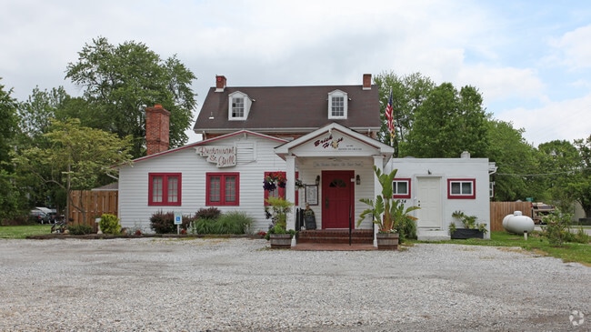

Property Detail
1530 Cedarhurst Rd
07-155-01411205
LT 1 CEDARHURST ON THE BAY
Restaurantbuilding
ANNE ARUNDEL
R5
Maryland
C and X Area of minimal flood hazard, usually depicted on FIRMs as above the 500-year flood level.
1
2024
1.39 AC
2025
Southern Anne Arundel
707001
Baltimore
4,212 SF
Baltimore-Columbia-Towson, MD
NEARBY LISTINGS FOR SALE OR LEASE
-
-
View all Shady Side listings for sale on LoopNet.com
DEMOGRAPHICS near 1530 Cedarhurst Rd
1 mile
3 mile
5 mile
2025 Total Population
2,328
9,112
16,382
2030 Population
2,408
9,280
16,648
Pop Growth 2025-2030
+ 3.44%
+ 1.84%
+ 1.62%
Average Age
42
43
43
2025 Total Households
936
3,612
6,437
HH Growth 2025-2030
+ 3.53%
+ 1.94%
+ 1.71%
Median Household Inc
$107,128
$123,731
$125,775
Avg Household Size
2.50
2.50
2.50
2025 Avg HH Vehicles
2.00
2.00
2.00
Median Home Value
$382,320
$424,335
$472,116
Median Year Built
1984
1982
1979
Nearby Places
Map Layers
Map Styles
 Street
 Aerial
Layers
 Traffic
 Biking
Places
Listings with unknown addresses are not visible on the map
- Restaurants
- Banks
- Shops
- Fitness
- Groceries
PUBLIC TRANSPORTATION
AIRPORT
Ronald Reagan Washington Ntl
Drive
Walk
Distance
Ronald Reagan Washington Ntl
63 min
37.0 mi
Baltimore/Washington International Thurgood Marshall
Drive
Walk
Distance
Baltimore/Washington International Thurgood Marshall
58 min
37.8 mi
Freight Ports
Port of Baltimore
Drive
Walk
Distance
Port of Baltimore
64 min
43.0 mi
Nearby Properties
Address
Land Use
TOTAL SIZE
Lot Size
Zoning
Address
Land Use
TOTAL SIZE
Lot Size
Zoning
65,982 SF
17.03 AC
R1
Address
Land Use
TOTAL SIZE
Lot Size
Zoning
8.38 AC
R1
Address
Land Use
TOTAL SIZE
Lot Size
Zoning
13,024 SF
5.51 AC
MC
Address
Land Use
TOTAL SIZE
Lot Size
Zoning
33,552 SF
3.77 AC
C3
Address
Land Use
TOTAL SIZE
Lot Size
Zoning
9,906 SF
1.04 AC
MC
Address
Land Use
TOTAL SIZE
Lot Size
Zoning
15,106 SF
13.34 AC
MC
Address
Land Use
TOTAL SIZE
Lot Size
Zoning
67,421 SF
6.98 AC
W1
Address
Land Use
TOTAL SIZE
Lot Size
Zoning
9,240 SF
1.49 AC
C3
Address
Land Use
TOTAL SIZE
Lot Size
Zoning
11,859 SF
3.22 AC
R1
Address
Land Use
TOTAL SIZE
Lot Size
Zoning
9,900 SF
44.58 AC
OS
Address
Land Use
TOTAL SIZE
Lot Size
Zoning
7,824 SF
2.98 AC
MA3
Address
Land Use
TOTAL SIZE
Lot Size
Zoning
1,477 SF
2.67 AC
W2
Address
Land Use
TOTAL SIZE
Lot Size
Zoning
9,324 SF
3.03 AC
R2
Address
Land Use
TOTAL SIZE
Lot Size
Zoning
4,637 SF
2.29 AC
C4
Address
Land Use
TOTAL SIZE
Lot Size
Zoning
2,052 SF
2.48 AC
W2
Address
Land Use
TOTAL SIZE
Lot Size
Zoning
11,416 SF
2.89 AC
R5
Address
Land Use
TOTAL SIZE
Lot Size
Zoning
11,352 SF
9.03 AC
R2
Address
Land Use
TOTAL SIZE
Lot Size
Zoning
18,270 SF
3.75 AC
MC
Address
Land Use
TOTAL SIZE
Lot Size
Zoning
3,272 SF
0.75 AC
MA2
Address
Land Use
TOTAL SIZE
Lot Size
Zoning
5,534 SF
1.29 AC
R1
Address
Land Use
TOTAL SIZE
Lot Size
Zoning
5,596 SF
2.62 AC
R1
Address
Land Use
TOTAL SIZE
Lot Size
Zoning
6,732 SF
1.24 AC
C3
Address
Land Use
TOTAL SIZE
Lot Size
Zoning
10,720 SF
1 AC
R2
Address
Land Use
TOTAL SIZE
Lot Size
Zoning
2,778 SF
0.37 AC
R2
Address
Land Use
TOTAL SIZE
Lot Size
Zoning
12.77 AC
C3
Address
Land Use
TOTAL SIZE
Lot Size
Zoning
8,964 SF
1.30 AC
C3
Address
Land Use
TOTAL SIZE
Lot Size
Zoning
19.51 AC
C3
Address
Land Use
TOTAL SIZE
Lot Size
Zoning
7,200 SF
0.40 AC
MC
Address
Land Use
TOTAL SIZE
Lot Size
Zoning
4,518 SF
1.51 AC
C1B
Address
Land Use
TOTAL SIZE
Lot Size
Zoning
15,284 SF
2.09 AC
W2
The World's #1 Commercial Real Estate Marketplace
Connect with us
© 2026 CoStar Group
The information above has been obtained from sources believed reliable. While we do not doubt its accuracy we have not verified it and make no guarantee, warranty or representation about it. It is your responsibility to independently confirm its accuracy and completeness. Any projections, opinions, assumptions, or estimates used are for example only and do not represent the current or future performance of the property. The value of this transaction to you depends on tax and other factors which should be evaluated by your tax, financial, and legal advisors. You and your advisors should conduct a careful, independent investigation of the property to determine to your satisfaction the suitability of the property for your needs.