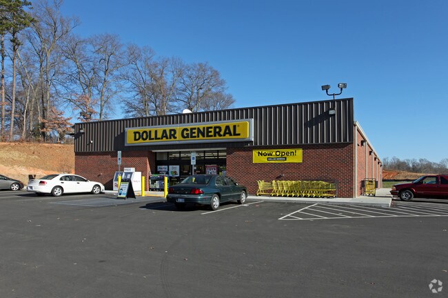
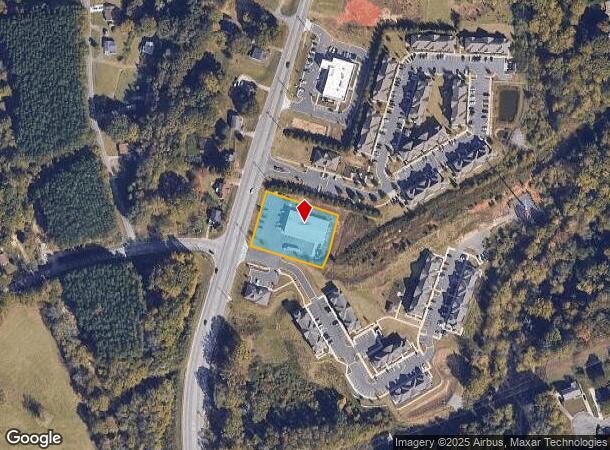
Property Record
1530 Lower Dallas Highway Hwy, , NC

NEARBY LISTINGS FOR SALE OR LEASE
Property Detail
1530 Lower Dallas Highway Hwy
223657
LOTS 1 & 2 13 106 026 00 000
Departmentstoremultistory
Gaston
X
North Carolina
3710355700J
1-2
2025
1.01 AC
2025
Gaston County
0309021046
Charlotte
9,238 SF
Charlotte-Concord-Gastonia, NC-SC
DEMOGRAPHICS near 1530 Lower Dallas Highway Hwy
1 Mile
3 Mile
5 Mile
2024 Total Population
6,248
30,240
83,552
2029 Population
6,604
32,185
89,017
Pop Growth 2024-2029
+ 5.70%
+ 6.43%
+ 6.54%
Average Age
37
38
39
2024 Total Households
2,382
11,644
33,517
HH Growth 2024-2029
+ 5.92%
+ 6.61%
+ 6.69%
Median Household Inc
$53,558
$44,557
$46,776
Avg Household Size
2.60
2.50
2.40
2024 Avg HH Vehicles
2.00
2.00
2.00
Median Home Value
$172,255
$166,543
$179,973
Median Year Built
1979
1974
1973
Nearby Places
Map Layers
Map Styles
 Street
 Aerial
- Restaurants
- Banks
- Shops
- Fitness
- Groceries
PUBLIC TRANSPORTATION
COMMUTER RAIL
Gastonia Amtrak Station (Crescent - Amtrak)
DRIVE
WALK
Distance
Gastonia Amtrak Station (Crescent - Amtrak)
6 min
3.2 mi
AIRPORT
Charlotte/Douglas International
DRIVE
WALK
Distance
Charlotte/Douglas International
31 min
17.4 mi
Concord-Padgett Regional
DRIVE
WALK
Distance
Concord-Padgett Regional
45 min
33.7 mi
Freight Ports
North Charleston Terminal
DRIVE
WALK
Distance
North Charleston Terminal
245 min
213.4 mi
Nearby Properties
Address
Land Use
TOTAL SIZE
Lot Size
Zoning
Address
Land Use
TOTAL SIZE
Lot Size
Zoning
56,000 SF
23.22 AC
GOV01
Address
Land Use
TOTAL SIZE
Lot Size
Zoning
11,696 SF
159.68 AC
Address
Land Use
TOTAL SIZE
Lot Size
Zoning
159,263 SF
9.83 AC
GOV01
Address
Land Use
TOTAL SIZE
Lot Size
Zoning
28.04 AC
Address
Land Use
TOTAL SIZE
Lot Size
Zoning
192,315 SF
44.12 AC
INDS1
Address
Land Use
TOTAL SIZE
Lot Size
Zoning
103,890 SF
8.81 AC
OFF04
Address
Land Use
TOTAL SIZE
Lot Size
Zoning
2,688 SF
22.48 AC
OFF01
Address
Land Use
TOTAL SIZE
Lot Size
Zoning
1,680 SF
19.08 AC
OFF01
Address
Land Use
TOTAL SIZE
Lot Size
Zoning
Address
Land Use
TOTAL SIZE
Lot Size
Zoning
18,803 SF
9.57 AC
SHOP3
Address
Land Use
TOTAL SIZE
Lot Size
Zoning
22.85 AC
Address
Land Use
TOTAL SIZE
Lot Size
Zoning
123,948 SF
6.94 AC
GOV05
Address
Land Use
TOTAL SIZE
Lot Size
Zoning
0.79 AC
RET01
Address
Land Use
TOTAL SIZE
Lot Size
Zoning
135,840 SF
11.21 AC
Address
Land Use
TOTAL SIZE
Lot Size
Zoning
411,076 SF
67.01 AC
INDS2
Address
Land Use
TOTAL SIZE
Lot Size
Zoning
53,260 SF
2.18 AC
HOTL1
Address
Land Use
TOTAL SIZE
Lot Size
Zoning
176,657 SF
16.19 AC
Address
Land Use
TOTAL SIZE
Lot Size
Zoning
960 SF
7.33 AC
APT02
Address
Land Use
TOTAL SIZE
Lot Size
Zoning
154,681 SF
63.07 AC
INDS1
Address
Land Use
TOTAL SIZE
Lot Size
Zoning
83,664 SF
2.23 AC
HOTL1
Address
Land Use
TOTAL SIZE
Lot Size
Zoning
163,100 SF
41.60 AC
INDS1
Address
Land Use
TOTAL SIZE
Lot Size
Zoning
16,776 SF
49.87 AC
PUB01
Address
Land Use
TOTAL SIZE
Lot Size
Zoning
50,661 SF
2.32 AC
R1
Address
Land Use
TOTAL SIZE
Lot Size
Zoning
148,300 SF
12.59 AC
INDS2
Address
Land Use
TOTAL SIZE
Lot Size
Zoning
1,914 SF
15.78 AC
MRKT1
Address
Land Use
TOTAL SIZE
Lot Size
Zoning
12.25 AC
Address
Land Use
TOTAL SIZE
Lot Size
Zoning
63,900 SF
2.41 AC
HOTL1
Address
Land Use
TOTAL SIZE
Lot Size
Zoning
49,316 SF
1.70 AC
HOTL1
Address
Land Use
TOTAL SIZE
Lot Size
Zoning
13,017 SF
10.75 AC
REST1
Address
Land Use
TOTAL SIZE
Lot Size
Zoning
46,807 SF
4.36 AC
The World's #1 Commercial Real Estate Marketplace
Connect with us
© 2025 CoStar Group
The information above has been obtained from sources believed reliable. While we do not doubt its accuracy we have not verified it and make no guarantee, warranty or representation about it. It is your responsibility to independently confirm its accuracy and completeness. Any projections, opinions, assumptions, or estimates used are for example only and do not represent the current or future performance of the property. The value of this transaction to you depends on tax and other factors which should be evaluated by your tax, financial, and legal advisors. You and your advisors should conduct a careful, independent investigation of the property to determine to your satisfaction the suitability of the property for your needs.