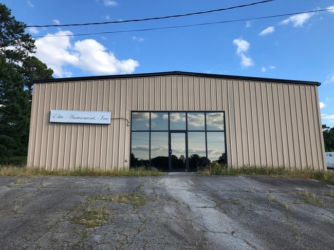
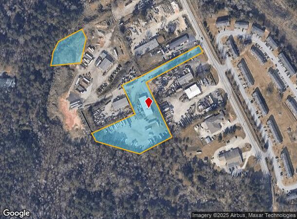
Property Record
1530 Rockbridge Rd Nw, Conyers, GA 30012

NEARBY LISTINGS FOR SALE OR LEASE
Property Detail
1530 Rockbridge Rd Nw
Atlanta-Sandy Springs-Roswell, GA
Commercial
041-0-01-0015
ROCKBRIDGE RD & W/SIDE
Publicstorage
Rockdale
X
Georgia
13247C0091D
265
2024
3.91 AC
2024
Rockdale/Newton Cnty
060310
Atlanta
6,340 SF
DEMOGRAPHICS near 1530 Rockbridge Rd Nw
1 Mile
3 Mile
5 Mile
2024 Total Population
5,578
33,145
74,936
2029 Population
5,795
34,295
77,013
Pop Growth 2024-2029
+ 3.89%
+ 3.47%
+ 2.77%
Average Age
35
38
39
2024 Total Households
2,004
11,949
27,233
HH Growth 2024-2029
+ 3.89%
+ 3.43%
+ 2.63%
Median Household Inc
$52,724
$56,902
$63,327
Avg Household Size
2.70
2.60
2.70
2024 Avg HH Vehicles
2.00
2.00
2.00
Median Home Value
$165,226
$185,056
$204,409
Median Year Built
1986
1984
1990
Nearby Places
Map Layers
Map Styles
 Street
 Aerial
- Restaurants
- Banks
- Shops
- Fitness
- Groceries
PUBLIC TRANSPORTATION
AIRPORT
Hartsfield - Jackson Atlanta International
DRIVE
WALK
Distance
Hartsfield - Jackson Atlanta International
39 min
26.8 mi
SALE & LEASE HISTORY
LISTING DATE
SALE/LEASE

Sep 25, 2016
For Lease
Sep 24, 2016
For Sale
Jun 02, 2021
For Sale
Nearby Properties
Address
Land Use
TOTAL SIZE
Lot Size
Zoning
Address
Land Use
TOTAL SIZE
Lot Size
Zoning
22,362 SF
28.90 AC
MXD
Address
Land Use
TOTAL SIZE
Lot Size
Zoning
2,782 SF
29.51 AC
R3/C
Address
Land Use
TOTAL SIZE
Lot Size
Zoning
290,616 SF
23.84 AC
M-1
Address
Land Use
TOTAL SIZE
Lot Size
Zoning
458,448 SF
12.98 AC
OI
Address
Land Use
TOTAL SIZE
Lot Size
Zoning
28,024 SF
11.24 AC
R1
Address
Land Use
TOTAL SIZE
Lot Size
Zoning
3,256 SF
22.05 AC
RM
Address
Land Use
TOTAL SIZE
Lot Size
Zoning
20,964 SF
25.29 AC
R3/C
Address
Land Use
TOTAL SIZE
Lot Size
Zoning
3,066 SF
22.44 AC
R3/R1
Address
Land Use
TOTAL SIZE
Lot Size
Zoning
165,171 SF
49.79 AC
BG/ID
Address
Land Use
TOTAL SIZE
Lot Size
Zoning
3,648 SF
1.02 AC
R3/R1
Address
Land Use
TOTAL SIZE
Lot Size
Zoning
417,378 SF
31.95 AC
M1
Address
Land Use
TOTAL SIZE
Lot Size
Zoning
173,427 SF
15.18 AC
X
Address
Land Use
TOTAL SIZE
Lot Size
Zoning
273,000 SF
15.41 AC
M1
Address
Land Use
TOTAL SIZE
Lot Size
Zoning
3,888 SF
21.05 AC
RM/C
Address
Land Use
TOTAL SIZE
Lot Size
Zoning
77,600 SF
9 AC
GVUV
Address
Land Use
TOTAL SIZE
Lot Size
Zoning
17,800 SF
11.36 AC
RM/C
Address
Land Use
TOTAL SIZE
Lot Size
Zoning
472,620 SF
55.20 AC
RS10
Address
Land Use
TOTAL SIZE
Lot Size
Zoning
6,561 SF
7.49 AC
GVUV
Address
Land Use
TOTAL SIZE
Lot Size
Zoning
76,140 SF
22.20 AC
RM
Address
Land Use
TOTAL SIZE
Lot Size
Zoning
485,258 SF
23.61 AC
M
Address
Land Use
TOTAL SIZE
Lot Size
Zoning
199,146 SF
22.60 AC
HSB
Address
Land Use
TOTAL SIZE
Lot Size
Zoning
140,850 SF
19.09 AC
ID
Address
Land Use
TOTAL SIZE
Lot Size
Zoning
159,014 SF
3.88 AC
RM
Address
Land Use
TOTAL SIZE
Lot Size
Zoning
60,470 SF
5.11 AC
C2
Address
Land Use
TOTAL SIZE
Lot Size
Zoning
235,000 SF
16.25 AC
M1
Address
Land Use
TOTAL SIZE
Lot Size
Zoning
57,600 SF
10.20 AC
ID
Address
Land Use
TOTAL SIZE
Lot Size
Zoning
28,012 SF
4.04 AC
OI
Address
Land Use
TOTAL SIZE
Lot Size
Zoning
196,560 SF
12.06 AC
MI
Address
Land Use
TOTAL SIZE
Lot Size
Zoning
14,575 SF
14.55 AC
OI
Address
Land Use
TOTAL SIZE
Lot Size
Zoning
1,968 SF
26.91 AC
M2
The World's #1 Commercial Real Estate Marketplace
Connect with us
© 2025 CoStar Group
The information above has been obtained from sources believed reliable. While we do not doubt its accuracy we have not verified it and make no guarantee, warranty or representation about it. It is your responsibility to independently confirm its accuracy and completeness. Any projections, opinions, assumptions, or estimates used are for example only and do not represent the current or future performance of the property. The value of this transaction to you depends on tax and other factors which should be evaluated by your tax, financial, and legal advisors. You and your advisors should conduct a careful, independent investigation of the property to determine to your satisfaction the suitability of the property for your needs.