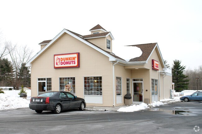
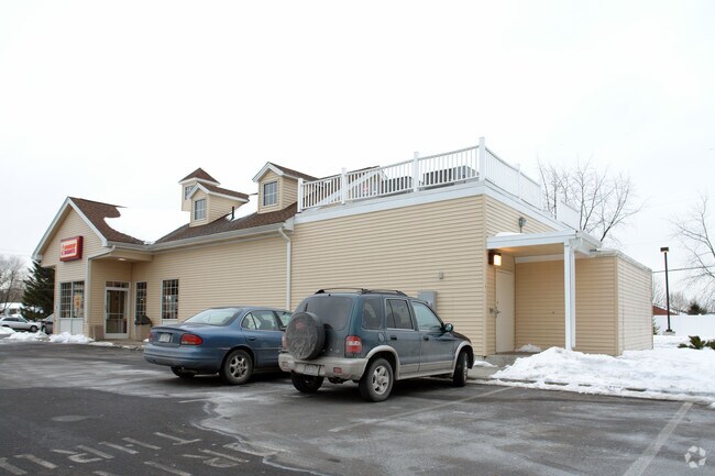
Property Record
1530 Route 9, Halfmoon, NY 12065

Property Detail
1530 Route 9
Albany-Schenectady-Troy, NY
DUNKIN DONUT
413800-278-000-0002-038-000-0000
SARATOGA
Restaurantdrivein
New York
05 - COMME
38.000
2025
0.85 AC
2025
Saratoga County
062410
Albany/Schenectady/Troy
2,409 SF
NEARBY LISTINGS FOR SALE OR LEASE
-
-
View all Halfmoon listings for sale on LoopNet.com
DEMOGRAPHICS near 1530 Route 9
1 mile
3 mile
5 mile
2025 Total Population
5,459
34,296
72,229
2030 Population
5,349
34,243
72,267
Pop Growth 2025-2030
(2.02%)
(0.15%)
+ 0.05%
Average Age
43
43
43
2025 Total Households
2,494
14,699
30,314
HH Growth 2025-2030
(1.84%)
(0.26%)
(0.02%)
Median Household Inc
$99,751
$102,843
$102,349
Avg Household Size
2.20
2.30
2.30
2025 Avg HH Vehicles
2.00
2.00
2.00
Median Home Value
$365,638
$376,592
$372,200
Median Year Built
1987
1986
1983
Nearby Places
Map Layers
Map Styles
 Street
 Aerial
Layers
 Traffic
 Biking
Places
Listings with unknown addresses are not visible on the map
- Restaurants
- Banks
- Shops
- Fitness
- Groceries
PUBLIC TRANSPORTATION
AIRPORT
Albany International
Drive
Walk
Distance
Albany International
15 min
9.4 mi
Freight Ports
Albany, NY Port
Drive
Walk
Distance
Albany, NY Port
29 min
18.8 mi
Nearby Properties
Address
Land Use
TOTAL SIZE
Lot Size
Zoning
Address
Land Use
TOTAL SIZE
Lot Size
Zoning
2,655 SF
47.22 AC
07 - MIXED
Address
Land Use
TOTAL SIZE
Lot Size
Zoning
5,091 SF
33.35 AC
02 - SINGL
Address
Land Use
TOTAL SIZE
Lot Size
Zoning
4,680 SF
26.74 AC
Address
Land Use
TOTAL SIZE
Lot Size
Zoning
12,234 SF
32 AC
05 - COMME
Address
Land Use
TOTAL SIZE
Lot Size
Zoning
12,294 SF
36.70 AC
03 - MULTI
Address
Land Use
TOTAL SIZE
Lot Size
Zoning
156,601 SF
13.69 AC
05 - COMME
Address
Land Use
TOTAL SIZE
Lot Size
Zoning
109,323 SF
45.52 AC
05 - COMME
Address
Land Use
TOTAL SIZE
Lot Size
Zoning
60,467 SF
6.94 AC
05 - COMME
Address
Land Use
TOTAL SIZE
Lot Size
Zoning
83,424 SF
25.63 AC
07 - MIXED
Address
Land Use
TOTAL SIZE
Lot Size
Zoning
183,632 SF
20.82 AC
05 - COMME
Address
Land Use
TOTAL SIZE
Lot Size
Zoning
195,069 SF
28.40 AC
07 - MIXED
Address
Land Use
TOTAL SIZE
Lot Size
Zoning
22,401 SF
9.69 AC
25
Address
Land Use
TOTAL SIZE
Lot Size
Zoning
147,200 SF
13.62 AC
05 - COMME
Address
Land Use
TOTAL SIZE
Lot Size
Zoning
159,571 SF
22.89 AC
05 - COMME
Address
Land Use
TOTAL SIZE
Lot Size
Zoning
52,117 SF
12.18 AC
08 - GOVER
Address
Land Use
TOTAL SIZE
Lot Size
Zoning
23,402 SF
5.84 AC
25
Address
Land Use
TOTAL SIZE
Lot Size
Zoning
15,727 SF
11.27 AC
04 - FARM
Address
Land Use
TOTAL SIZE
Lot Size
Zoning
125,739 SF
20.02 AC
05 - COMME
Address
Land Use
TOTAL SIZE
Lot Size
Zoning
34,234 SF
17.27 AC
07 - MIXED
Address
Land Use
TOTAL SIZE
Lot Size
Zoning
15,435 SF
23.68 AC
04 - FARM
Address
Land Use
TOTAL SIZE
Lot Size
Zoning
38,110 SF
7.01 AC
05 - COMME
Address
Land Use
TOTAL SIZE
Lot Size
Zoning
134,095 SF
15.39 AC
05 - COMME
Address
Land Use
TOTAL SIZE
Lot Size
Zoning
58,966 SF
8.03 AC
07 - MIXED
Address
Land Use
TOTAL SIZE
Lot Size
Zoning
88,110 SF
11.52 AC
05 - COMME
Address
Land Use
TOTAL SIZE
Lot Size
Zoning
81,168 SF
7.96 AC
07 - MIXED
Address
Land Use
TOTAL SIZE
Lot Size
Zoning
1,440 SF
42.94 AC
05 - COMME
Address
Land Use
TOTAL SIZE
Lot Size
Zoning
116,325 SF
13.41 AC
07 - MIXED
Address
Land Use
TOTAL SIZE
Lot Size
Zoning
78,233 SF
3.71 AC
05 - COMME
Address
Land Use
TOTAL SIZE
Lot Size
Zoning
11,652 SF
15.46 AC
07 - MIXED
Address
Land Use
TOTAL SIZE
Lot Size
Zoning
95,175 SF
10.75 AC
05 - COMME
The World's #1 Commercial Real Estate Marketplace
Connect with us
© 2026 CoStar Group
The information above has been obtained from sources believed reliable. While we do not doubt its accuracy we have not verified it and make no guarantee, warranty or representation about it. It is your responsibility to independently confirm its accuracy and completeness. Any projections, opinions, assumptions, or estimates used are for example only and do not represent the current or future performance of the property. The value of this transaction to you depends on tax and other factors which should be evaluated by your tax, financial, and legal advisors. You and your advisors should conduct a careful, independent investigation of the property to determine to your satisfaction the suitability of the property for your needs.