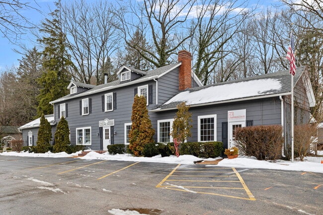
Property Record
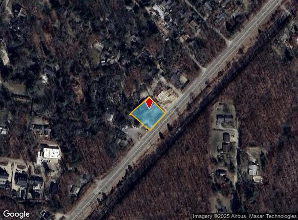
15300 Red Arrow Hwy, Union Pier, MI 49129
NEARBY LISTINGS FOR SALE OR LEASE
-
-
View all Union Pier listings for sale on LoopNet.com
Property Detail
15300 Red Arrow Hwy
Niles-Benton Harbor, MI
Lakeside Park
11-07-4460-0035-06-6
PT OF LOTS 35 & 36 LAKESIDE PARK COM 15' S51DEG19'E & 104.28' S43DEG21'W OF MOST NLY COR LOT 35 TH S42DEG39'E 135.35' TO WLY LN RED ARROW HWY TH S43DEG21'W ON SD WLY LN 128.93' TH N50DEG54'W 135.25' TH N83DEG34'W 17.8' TH N48DEG24'40''E 159.7' TO POB
Commercialnec
Berrien
X
Michigan
26021C0335D
35-36
2024
0.40 AC
2025
Michigan Southwest Area
011201
Other Market Areas
8,022 SF
DEMOGRAPHICS near 15300 Red Arrow Hwy
1 Mile
3 Mile
5 Mile
2024 Total Population
616
2,652
8,202
2029 Population
660
2,812
8,552
Pop Growth 2024-2029
+ 7.14%
+ 6.03%
+ 4.27%
Average Age
59
54
51
2024 Total Households
338
1,341
3,968
HH Growth 2024-2029
+ 7.10%
+ 6.04%
+ 4.33%
Median Household Inc
$80,909
$76,339
$69,256
Avg Household Size
1.80
2.00
2.10
2024 Avg HH Vehicles
1.00
2.00
2.00
Median Home Value
$467,499
$394,166
$292,235
Median Year Built
1960
1969
1970
Nearby Places
Map Layers
Map Styles
 Street
 Aerial
- Restaurants
- Banks
- Shops
- Fitness
- Groceries
PUBLIC TRANSPORTATION
COMMUTER RAIL
DRIVE
WALK
Distance
9 min
5.3 mi
AIRPORT
South Bend International
DRIVE
WALK
Distance
South Bend International
57 min
32.2 mi
SALE & LEASE HISTORY
LISTING DATE
SALE/LEASE

Jan 29, 2024
For Sale
Nearby Properties
Address
Land Use
TOTAL SIZE
Lot Size
Zoning
Address
Land Use
TOTAL SIZE
Lot Size
Zoning
Address
Land Use
TOTAL SIZE
Lot Size
Zoning
14,542 SF
4.10 AC
R-1
Address
Land Use
TOTAL SIZE
Lot Size
Zoning
2.55 AC
Address
Land Use
TOTAL SIZE
Lot Size
Zoning
Address
Land Use
TOTAL SIZE
Lot Size
Zoning
1.56 AC
Address
Land Use
TOTAL SIZE
Lot Size
Zoning
1.81 AC
Address
Land Use
TOTAL SIZE
Lot Size
Zoning
162 SF
161.16 AC
Address
Land Use
TOTAL SIZE
Lot Size
Zoning
0.63 AC
Address
Land Use
TOTAL SIZE
Lot Size
Zoning
4,660 SF
49.10 AC
Address
Land Use
TOTAL SIZE
Lot Size
Zoning
1.37 AC
Address
Land Use
TOTAL SIZE
Lot Size
Zoning
2,600 SF
34.89 AC
Address
Land Use
TOTAL SIZE
Lot Size
Zoning
7,632 SF
1.07 AC
R-1
Address
Land Use
TOTAL SIZE
Lot Size
Zoning
86.91 AC
Address
Land Use
TOTAL SIZE
Lot Size
Zoning
0.74 AC
R-1
Address
Land Use
TOTAL SIZE
Lot Size
Zoning
0.84 AC
Address
Land Use
TOTAL SIZE
Lot Size
Zoning
1.27 AC
Address
Land Use
TOTAL SIZE
Lot Size
Zoning
5.78 AC
Address
Land Use
TOTAL SIZE
Lot Size
Zoning
0.72 AC
Address
Land Use
TOTAL SIZE
Lot Size
Zoning
2,791 SF
62.43 AC
Address
Land Use
TOTAL SIZE
Lot Size
Zoning
60,475 SF
Address
Land Use
TOTAL SIZE
Lot Size
Zoning
2.76 AC
R-1
Address
Land Use
TOTAL SIZE
Lot Size
Zoning
0.74 AC
R-1
Address
Land Use
TOTAL SIZE
Lot Size
Zoning
1.71 AC
Address
Land Use
TOTAL SIZE
Lot Size
Zoning
1.70 AC
R-1
Address
Land Use
TOTAL SIZE
Lot Size
Zoning
3.95 AC
Address
Land Use
TOTAL SIZE
Lot Size
Zoning
0.67 AC
SELECTZONI
Address
Land Use
TOTAL SIZE
Lot Size
Zoning
0.56 AC
SELECTZONI
Address
Land Use
TOTAL SIZE
Lot Size
Zoning
0.49 AC
R-1
Address
Land Use
TOTAL SIZE
Lot Size
Zoning
0.41 AC
R-1
Address
Land Use
TOTAL SIZE
Lot Size
Zoning
0.40 AC
R-1
The World's #1 Commercial Real Estate Marketplace
Connect with us
© 2025 CoStar Group
The information above has been obtained from sources believed reliable. While we do not doubt its accuracy we have not verified it and make no guarantee, warranty or representation about it. It is your responsibility to independently confirm its accuracy and completeness. Any projections, opinions, assumptions, or estimates used are for example only and do not represent the current or future performance of the property. The value of this transaction to you depends on tax and other factors which should be evaluated by your tax, financial, and legal advisors. You and your advisors should conduct a careful, independent investigation of the property to determine to your satisfaction the suitability of the property for your needs.