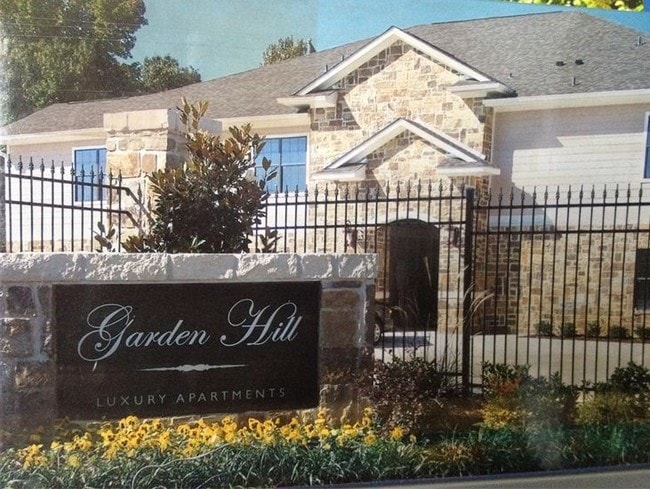
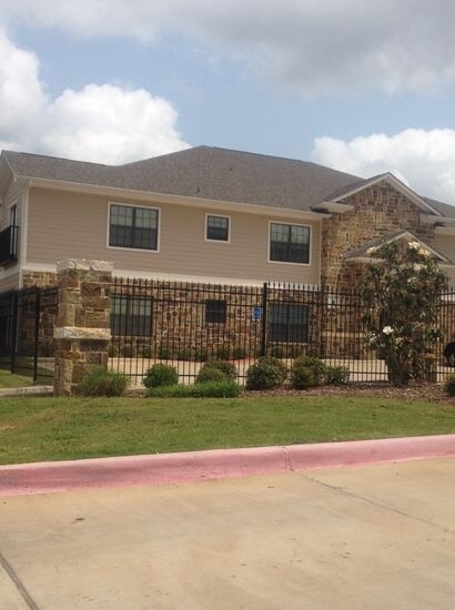
Property Record
15307 Fm 16 W, Lindale, TX 75771


Property Detail
15307 Fm 16 W
1-00000-0071-01-034000
ABST A0071 T BURBRIDGE ABST A0071 T BURBRIDGE ABST A0071 T BURBRIDGE ABST A0071 T BURBRIDGE TRACT 34.3 & 38 TRACT 34A S01
Apartment
Smith
B and X Area of moderate flood hazard, usually the area between the limits of the 100-year and 500-year floods.
Texas
2025
6.94 AC
2025
Tyler
001407
Other Market Areas
2,094 SF
Tyler, TX
NEARBY LISTINGS FOR SALE OR LEASE
DEMOGRAPHICS near 15307 Fm 16 W
1 mile
3 mile
5 mile
2025 Total Population
4,358
15,443
22,445
2030 Population
4,670
16,482
23,946
Pop Growth 2025-2030
+ 7.16%
+ 6.73%
+ 6.69%
Average Age
39
41
41
2025 Total Households
1,551
5,700
8,303
HH Growth 2025-2030
+ 6.71%
+ 6.23%
+ 6.20%
Median Household Inc
$99,289
$95,009
$94,384
Avg Household Size
2.60
2.60
2.60
2025 Avg HH Vehicles
2.00
2.00
2.00
Median Home Value
$279,393
$301,918
$316,577
Median Year Built
1989
1994
1994
Nearby Places
Map Layers
Map Styles
 Street
 Aerial
Layers
 Traffic
 Biking
Places
Listings with unknown addresses are not visible on the map
- Restaurants
- Banks
- Shops
- Fitness
- Groceries
PUBLIC TRANSPORTATION
AIRPORT
Tyler Pounds Regional
Drive
Walk
Distance
Tyler Pounds Regional
21 min
14.2 mi
Freight Ports
Port of Shreveport
Drive
Walk
Distance
Port of Shreveport
126 min
113.1 mi
Nearby Properties
Address
Land Use
TOTAL SIZE
Lot Size
Zoning
Address
Land Use
TOTAL SIZE
Lot Size
Zoning
87,195 SF
5.44 AC
Address
Land Use
TOTAL SIZE
Lot Size
Zoning
32,238 SF
10.61 AC
Address
Land Use
TOTAL SIZE
Lot Size
Zoning
17,597 SF
9.36 AC
Address
Land Use
TOTAL SIZE
Lot Size
Zoning
26.50 AC
Address
Land Use
TOTAL SIZE
Lot Size
Zoning
58,400 SF
2.56 AC
Address
Land Use
TOTAL SIZE
Lot Size
Zoning
104,953 SF
6.37 AC
Address
Land Use
TOTAL SIZE
Lot Size
Zoning
13.26 AC
Address
Land Use
TOTAL SIZE
Lot Size
Zoning
3,063 SF
8.25 AC
Address
Land Use
TOTAL SIZE
Lot Size
Zoning
29,024 SF
1.27 AC
Address
Land Use
TOTAL SIZE
Lot Size
Zoning
4.31 AC
Address
Land Use
TOTAL SIZE
Lot Size
Zoning
3,200 SF
3.47 AC
Address
Land Use
TOTAL SIZE
Lot Size
Zoning
16,625 SF
5.82 AC
Address
Land Use
TOTAL SIZE
Lot Size
Zoning
2,400 SF
3.21 AC
Address
Land Use
TOTAL SIZE
Lot Size
Zoning
16,950 SF
10.48 AC
Address
Land Use
TOTAL SIZE
Lot Size
Zoning
1,036 SF
5.53 AC
Address
Land Use
TOTAL SIZE
Lot Size
Zoning
18,510 SF
3.19 AC
Address
Land Use
TOTAL SIZE
Lot Size
Zoning
3.18 AC
Address
Land Use
TOTAL SIZE
Lot Size
Zoning
10,000 SF
1 AC
Address
Land Use
TOTAL SIZE
Lot Size
Zoning
6,981 SF
1.68 AC
Address
Land Use
TOTAL SIZE
Lot Size
Zoning
10,164 SF
0.91 AC
Address
Land Use
TOTAL SIZE
Lot Size
Zoning
1,988 SF
3.04 AC
Address
Land Use
TOTAL SIZE
Lot Size
Zoning
10,999 SF
0.54 AC
Address
Land Use
TOTAL SIZE
Lot Size
Zoning
15,232 SF
4.37 AC
Address
Land Use
TOTAL SIZE
Lot Size
Zoning
44,147 SF
Address
Land Use
TOTAL SIZE
Lot Size
Zoning
Address
Land Use
TOTAL SIZE
Lot Size
Zoning
4,200 SF
3.10 AC
Address
Land Use
TOTAL SIZE
Lot Size
Zoning
21,400 SF
3.45 AC
Address
Land Use
TOTAL SIZE
Lot Size
Zoning
3,200 SF
42.75 AC
Address
Land Use
TOTAL SIZE
Lot Size
Zoning
3,928 SF
1.20 AC
The World's #1 Commercial Real Estate Marketplace
Connect with us
© 2026 CoStar Group
The information above has been obtained from sources believed reliable. While we do not doubt its accuracy we have not verified it and make no guarantee, warranty or representation about it. It is your responsibility to independently confirm its accuracy and completeness. Any projections, opinions, assumptions, or estimates used are for example only and do not represent the current or future performance of the property. The value of this transaction to you depends on tax and other factors which should be evaluated by your tax, financial, and legal advisors. You and your advisors should conduct a careful, independent investigation of the property to determine to your satisfaction the suitability of the property for your needs.