Property Record
1531 Airport Rhodhiss Rd, Hickory, NC 28601

NEARBY LISTINGS FOR SALE OR LEASE
-
-
View all Hickory listings for sale on LoopNet.com
Property Detail
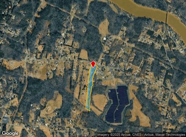
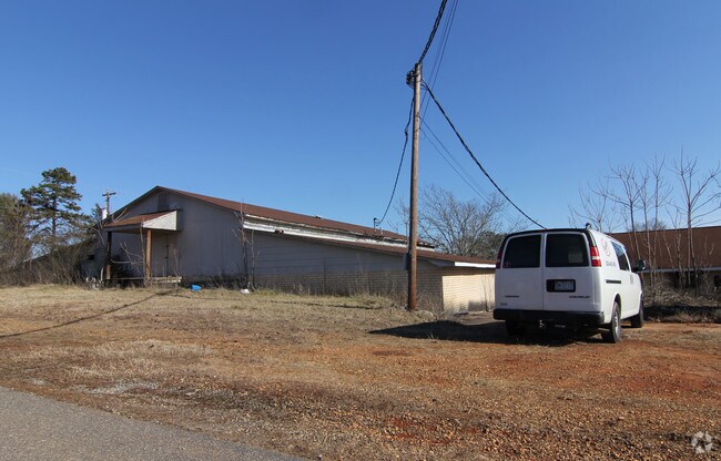
1531 Airport Rhodhiss Rd
28622
Minor Subdivision Hanna E Wilson
Manufacturinglight
1531 AIRPORT RHODHISS RD HICKORY, NC 28601
X
Burke
3710278300K
North Carolina
2025
7.97 AC
2025
Burke County
010402
Charlotte
6,000 SF
Hickory-Lenoir-Morganton, NC
DEMOGRAPHICS near 1531 Airport Rhodhiss Rd
1 Mile
3 Mile
5 Mile
2024 Total Population
1,942
13,617
45,059
2029 Population
1,973
13,724
45,861
Pop Growth 2024-2029
+ 1.60%
+ 0.79%
+ 1.78%
Average Age
42
42
42
2024 Total Households
763
5,458
18,312
HH Growth 2024-2029
+ 1.57%
+ 0.81%
+ 1.85%
Median Household Inc
$60,142
$49,974
$56,113
Avg Household Size
2.50
2.40
2.40
2024 Avg HH Vehicles
2.00
2.00
2.00
Median Home Value
$104,484
$145,380
$183,055
Median Year Built
1986
1978
1977
Nearby Places
Map Layers
Map Styles
 Street
 Aerial
- Restaurants
- Banks
- Shops
- Fitness
- Groceries
Nearby Properties
Address
Land Use
TOTAL SIZE
Lot Size
Zoning
Address
Land Use
TOTAL SIZE
Lot Size
Zoning
534,243 SF
285.78 AC
Address
Land Use
TOTAL SIZE
Lot Size
Zoning
7,240 SF
INDUSTRIAL
Address
Land Use
TOTAL SIZE
Lot Size
Zoning
187,241 SF
25.01 AC
Address
Land Use
TOTAL SIZE
Lot Size
Zoning
26,955 SF
16.44 AC
Address
Land Use
TOTAL SIZE
Lot Size
Zoning
73,872 SF
NO ZONING
Address
Land Use
TOTAL SIZE
Lot Size
Zoning
57,198 SF
16.07 AC
Address
Land Use
TOTAL SIZE
Lot Size
Zoning
301,264 SF
19.88 AC
I
Address
Land Use
TOTAL SIZE
Lot Size
Zoning
20,503 SF
16.55 AC
INDUSTRIAL
Address
Land Use
TOTAL SIZE
Lot Size
Zoning
39,738 SF
11.80 AC
Address
Land Use
TOTAL SIZE
Lot Size
Zoning
240,210 SF
11.64 AC
I
Address
Land Use
TOTAL SIZE
Lot Size
Zoning
9,808 SF
51.64 AC
PD
Address
Land Use
TOTAL SIZE
Lot Size
Zoning
99,512 SF
6.04 AC
Address
Land Use
TOTAL SIZE
Lot Size
Zoning
24,496 SF
2.48 AC
Address
Land Use
TOTAL SIZE
Lot Size
Zoning
52,195 SF
6.46 AC
C-2
Address
Land Use
TOTAL SIZE
Lot Size
Zoning
42,672 SF
7.51 AC
Address
Land Use
TOTAL SIZE
Lot Size
Zoning
38,384 SF
348 AC
Address
Land Use
TOTAL SIZE
Lot Size
Zoning
1,860 SF
GENERAL BU
Address
Land Use
TOTAL SIZE
Lot Size
Zoning
17,248 SF
INDUSTRIAL
Address
Land Use
TOTAL SIZE
Lot Size
Zoning
19,107 SF
R-3 DIST -
Address
Land Use
TOTAL SIZE
Lot Size
Zoning
94,782 SF
64.41 AC
IND
Address
Land Use
TOTAL SIZE
Lot Size
Zoning
57,342 SF
2.35 AC
C-2
Address
Land Use
TOTAL SIZE
Lot Size
Zoning
91,379 SF
11.89 AC
GENERAL MA
Address
Land Use
TOTAL SIZE
Lot Size
Zoning
92,500 SF
22.91 AC
GENERAL MA
Address
Land Use
TOTAL SIZE
Lot Size
Zoning
40,044 SF
3.50 AC
C-2
Address
Land Use
TOTAL SIZE
Lot Size
Zoning
61,621 SF
14.17 AC
OI
Address
Land Use
TOTAL SIZE
Lot Size
Zoning
9,147 SF
633 AC
Address
Land Use
TOTAL SIZE
Lot Size
Zoning
6,148 SF
6.70 AC
Address
Land Use
TOTAL SIZE
Lot Size
Zoning
131,144 SF
10.76 AC
I
Address
Land Use
TOTAL SIZE
Lot Size
Zoning
11,261 SF
15.98 AC
The World's #1 Commercial Real Estate Marketplace
Connect with us
© 2025 CoStar Group
The information above has been obtained from sources believed reliable. While we do not doubt its accuracy we have not verified it and make no guarantee, warranty or representation about it. It is your responsibility to independently confirm its accuracy and completeness. Any projections, opinions, assumptions, or estimates used are for example only and do not represent the current or future performance of the property. The value of this transaction to you depends on tax and other factors which should be evaluated by your tax, financial, and legal advisors. You and your advisors should conduct a careful, independent investigation of the property to determine to your satisfaction the suitability of the property for your needs.