Property Record
1531 Old State Route 74, Batavia, OH 45103
NEARBY LISTINGS FOR SALE OR LEASE
-
-
View all Batavia listings for sale on LoopNet.com
Property Detail
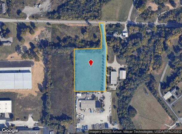
1531 Old State Route 74
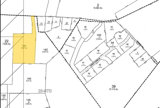
01-20-07D-141
Clermont
Industrialacreage
Ohio
X
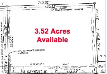
3.53 AC
39025C0229G
Eastgate/Anderson Twp
2024
Cincinnati/Dayton
2024
Cincinnati, OH-KY-IN
041102
DEMOGRAPHICS near 1531 Old State Route 74
1 Mile
3 Mile
5 Mile
2024 Total Population
3,888
34,272
82,222
2029 Population
4,088
35,352
84,693
Pop Growth 2024-2029
+ 5.14%
+ 3.15%
+ 3.01%
Average Age
40
40
40
2024 Total Households
1,628
13,668
33,396
HH Growth 2024-2029
+ 5.10%
+ 3.32%
+ 3.10%
Median Household Inc
$61,172
$69,753
$66,564
Avg Household Size
2.30
2.40
2.40
2024 Avg HH Vehicles
2.00
2.00
2.00
Median Home Value
$282,130
$232,247
$216,053
Median Year Built
2003
1992
1988
Nearby Places
Map Layers
Map Styles
 Street
 Aerial
- Restaurants
- Banks
- Shops
- Fitness
- Groceries
PUBLIC TRANSPORTATION
AIRPORT
Cincinnati/Northern Kentucky International
DRIVE
WALK
Distance
Cincinnati/Northern Kentucky International
46 min
30.3 mi
Freight Ports
Port of Toledo
DRIVE
WALK
Distance
Port of Toledo
250 min
213.5 mi
SALE & LEASE HISTORY
LISTING DATE
SALE/LEASE

Sep 24, 2016
For Sale
Nearby Properties
Address
Land Use
TOTAL SIZE
Lot Size
Zoning
Address
Land Use
TOTAL SIZE
Lot Size
Zoning
7,560 SF
79.10 AC
Address
Land Use
TOTAL SIZE
Lot Size
Zoning
104,856 SF
32.81 AC
Address
Land Use
TOTAL SIZE
Lot Size
Zoning
11,636 SF
49.40 AC
Address
Land Use
TOTAL SIZE
Lot Size
Zoning
20,468 SF
143.20 AC
Address
Land Use
TOTAL SIZE
Lot Size
Zoning
49.15 AC
Address
Land Use
TOTAL SIZE
Lot Size
Zoning
Address
Land Use
TOTAL SIZE
Lot Size
Zoning
56,080 SF
4.40 AC
Address
Land Use
TOTAL SIZE
Lot Size
Zoning
42,078 SF
58.22 AC
Address
Land Use
TOTAL SIZE
Lot Size
Zoning
14.24 AC
Address
Land Use
TOTAL SIZE
Lot Size
Zoning
17,700 SF
50.11 AC
Address
Land Use
TOTAL SIZE
Lot Size
Zoning
83,608 SF
4.45 AC
Address
Land Use
TOTAL SIZE
Lot Size
Zoning
168,266 SF
105.07 AC
Address
Land Use
TOTAL SIZE
Lot Size
Zoning
59,730 SF
9.28 AC
Address
Land Use
TOTAL SIZE
Lot Size
Zoning
230,428 SF
32.44 AC
Address
Land Use
TOTAL SIZE
Lot Size
Zoning
22,109 SF
7.98 AC
Address
Land Use
TOTAL SIZE
Lot Size
Zoning
12,488 SF
32.85 AC
Address
Land Use
TOTAL SIZE
Lot Size
Zoning
17,253 SF
10.59 AC
Address
Land Use
TOTAL SIZE
Lot Size
Zoning
9,504 SF
24.04 AC
Address
Land Use
TOTAL SIZE
Lot Size
Zoning
275,706 SF
14.82 AC
Address
Land Use
TOTAL SIZE
Lot Size
Zoning
6,900 SF
37.76 AC
Address
Land Use
TOTAL SIZE
Lot Size
Zoning
26,404 SF
16.06 AC
Address
Land Use
TOTAL SIZE
Lot Size
Zoning
Address
Land Use
TOTAL SIZE
Lot Size
Zoning
35,046 SF
0.76 AC
Address
Land Use
TOTAL SIZE
Lot Size
Zoning
42,300 SF
10.72 AC
Address
Land Use
TOTAL SIZE
Lot Size
Zoning
29,856 SF
19.21 AC
Address
Land Use
TOTAL SIZE
Lot Size
Zoning
2,688 SF
16.09 AC
Address
Land Use
TOTAL SIZE
Lot Size
Zoning
53,614 SF
6.49 AC
Address
Land Use
TOTAL SIZE
Lot Size
Zoning
134,858 SF
15.44 AC
Address
Land Use
TOTAL SIZE
Lot Size
Zoning
20,482 SF
39.58 AC
Address
Land Use
TOTAL SIZE
Lot Size
Zoning
8,144 SF
41.50 AC
The World's #1 Commercial Real Estate Marketplace
Connect with us
© 2025 CoStar Group
The information above has been obtained from sources believed reliable. While we do not doubt its accuracy we have not verified it and make no guarantee, warranty or representation about it. It is your responsibility to independently confirm its accuracy and completeness. Any projections, opinions, assumptions, or estimates used are for example only and do not represent the current or future performance of the property. The value of this transaction to you depends on tax and other factors which should be evaluated by your tax, financial, and legal advisors. You and your advisors should conduct a careful, independent investigation of the property to determine to your satisfaction the suitability of the property for your needs.