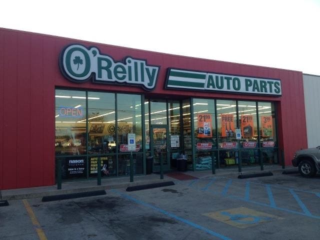
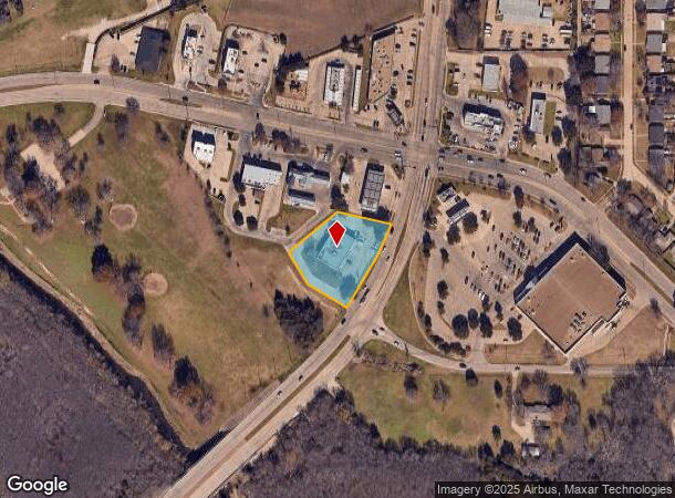
Property Record
1531 S Belt Line Rd, Mesquite, TX 75149
NEARBY LISTINGS FOR SALE OR LEASE
Property Detail
1531 S Belt Line Rd
Dallas-Fort Worth-Arlington, TX
Bruton Belt Line Retail
380129900B0020000
BRUTON BELT LINE RETAIL BLK B LT 2 ACS 1.141 INT201400094156 DD01012014 CO-DC 0129900B00200 3CM0129900B
Storebuilding
Dallas
X
Texas
48257C0150E
2
2024
1.14 AC
2025
Mesquite
017203
Dallas/Ft Worth
7,280 SF
DEMOGRAPHICS near 1531 S Belt Line Rd
1 Mile
3 Mile
5 Mile
2024 Total Population
10,771
99,743
228,204
2029 Population
10,610
98,736
225,610
Pop Growth 2024-2029
(1.49%)
(1.01%)
(1.14%)
Average Age
37
35
34
2024 Total Households
3,595
30,281
68,648
HH Growth 2024-2029
(1.86%)
(1.30%)
(1.46%)
Median Household Inc
$69,137
$59,146
$56,593
Avg Household Size
2.90
3.20
3.20
2024 Avg HH Vehicles
2.00
2.00
2.00
Median Home Value
$191,712
$184,973
$182,068
Median Year Built
1983
1983
1983
Nearby Places
Map Layers
Map Styles
 Street
 Aerial
- Restaurants
- Banks
- Shops
- Fitness
- Groceries
PUBLIC TRANSPORTATION
AIRPORT
Dallas Love Field
DRIVE
WALK
Distance
Dallas Love Field
34 min
20.7 mi
Dallas-Fort Worth International
DRIVE
WALK
Distance
Dallas-Fort Worth International
47 min
38.8 mi
Nearby Properties
Address
Land Use
TOTAL SIZE
Lot Size
Zoning
Address
Land Use
TOTAL SIZE
Lot Size
Zoning
263,360 SF
42.98 AC
Z237
Address
Land Use
TOTAL SIZE
Lot Size
Zoning
441,799 SF
64.72 AC
Z05
Address
Land Use
TOTAL SIZE
Lot Size
Zoning
199,246 SF
15.32 AC
Z250
Address
Land Use
TOTAL SIZE
Lot Size
Zoning
194,385 SF
44.63 AC
Z396
Address
Land Use
TOTAL SIZE
Lot Size
Zoning
592,958 SF
32.34 AC
Address
Land Use
TOTAL SIZE
Lot Size
Zoning
144,858 SF
9.69 AC
Z206
Address
Land Use
TOTAL SIZE
Lot Size
Zoning
200,000 SF
8.11 AC
Address
Land Use
TOTAL SIZE
Lot Size
Zoning
255,008 SF
30.39 AC
Z250
Address
Land Use
TOTAL SIZE
Lot Size
Zoning
100 SF
0.01 AC
Z268
Address
Land Use
TOTAL SIZE
Lot Size
Zoning
290,916 SF
8.24 AC
Address
Land Use
TOTAL SIZE
Lot Size
Zoning
487,200 SF
29.56 AC
Z109
Address
Land Use
TOTAL SIZE
Lot Size
Zoning
193,000 SF
34.42 AC
Z05
Address
Land Use
TOTAL SIZE
Lot Size
Zoning
1,229,138 SF
115.08 AC
Z117
Address
Land Use
TOTAL SIZE
Lot Size
Zoning
622,615 SF
35 AC
Z104
Address
Land Use
TOTAL SIZE
Lot Size
Zoning
214,853 SF
6.60 AC
Z372
Address
Land Use
TOTAL SIZE
Lot Size
Zoning
407,195 SF
31.32 AC
Z109
Address
Land Use
TOTAL SIZE
Lot Size
Zoning
320,390 SF
21.50 AC
Z267
Address
Land Use
TOTAL SIZE
Lot Size
Zoning
395,065 SF
24.18 AC
Z206
Address
Land Use
TOTAL SIZE
Lot Size
Zoning
364,000 SF
40.25 AC
Z236
Address
Land Use
TOTAL SIZE
Lot Size
Zoning
298,150 SF
20.01 AC
Z14
Address
Land Use
TOTAL SIZE
Lot Size
Zoning
217,606 SF
10.01 AC
Z237
Address
Land Use
TOTAL SIZE
Lot Size
Zoning
295,916 SF
16.52 AC
Z104
Address
Land Use
TOTAL SIZE
Lot Size
Zoning
241,512 SF
12.61 AC
Address
Land Use
TOTAL SIZE
Lot Size
Zoning
80,461 SF
6.48 AC
Z372
Address
Land Use
TOTAL SIZE
Lot Size
Zoning
310,900 SF
18.01 AC
Address
Land Use
TOTAL SIZE
Lot Size
Zoning
107,376 SF
38.55 AC
Z372
Address
Land Use
TOTAL SIZE
Lot Size
Zoning
267,011 SF
11.11 AC
Z250
Address
Land Use
TOTAL SIZE
Lot Size
Zoning
174,200 SF
1 AC
Z372
Address
Land Use
TOTAL SIZE
Lot Size
Zoning
110,668 SF
8.05 AC
Z372
Address
Land Use
TOTAL SIZE
Lot Size
Zoning
56,325 SF
3.84 AC
Z28
The World's #1 Commercial Real Estate Marketplace
Connect with us
© 2025 CoStar Group
The information above has been obtained from sources believed reliable. While we do not doubt its accuracy we have not verified it and make no guarantee, warranty or representation about it. It is your responsibility to independently confirm its accuracy and completeness. Any projections, opinions, assumptions, or estimates used are for example only and do not represent the current or future performance of the property. The value of this transaction to you depends on tax and other factors which should be evaluated by your tax, financial, and legal advisors. You and your advisors should conduct a careful, independent investigation of the property to determine to your satisfaction the suitability of the property for your needs.