Property Record
1531 S Post Rd, Shelby, NC 28152
Property Detail
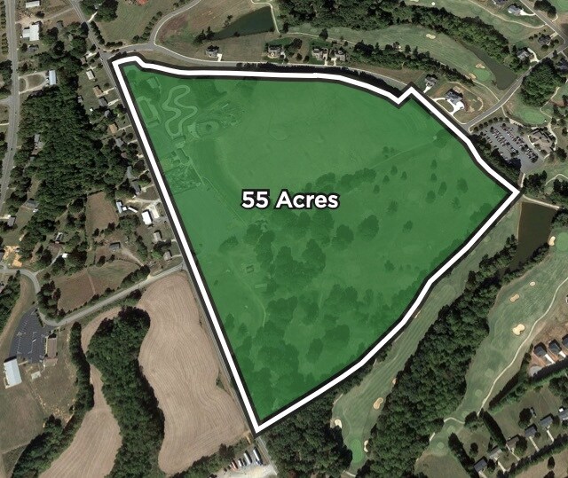
1531 S Post Rd
Shelby-Kings Mountain, NC
23.48AC HWY180
66600
CLEVELAND
Storebuilding
North Carolina
2025
37
2025
31.35 AC
950800
Cleveland County
2,276 SF
Charlotte
NEARBY LISTINGS FOR SALE OR LEASE
-
-
View all Shelby listings for sale on LoopNet.com
DEMOGRAPHICS near 1531 S Post Rd
1 mile
3 mile
5 mile
2025 Total Population
1,618
8,864
29,758
2030 Population
1,661
9,038
30,413
Pop Growth 2025-2030
+ 2.66%
+ 1.96%
+ 2.20%
Average Age
44
43
43
2025 Total Households
701
3,805
12,346
HH Growth 2025-2030
+ 2.57%
+ 1.92%
+ 2.20%
Median Household Inc
$73,032
$58,088
$62,226
Avg Household Size
2.20
2.20
2.30
2025 Avg HH Vehicles
2.00
2.00
2.00
Median Home Value
$294,195
$257,826
$263,399
Median Year Built
1984
1977
1977
Nearby Places
Map Layers
Map Styles
 Street
 Aerial
Layers
 Traffic
 Biking
Places
Listings with unknown addresses are not visible on the map
- Restaurants
- Banks
- Shops
- Fitness
- Groceries
SALE & LEASE HISTORY
LISTING DATE
SALE/LEASE

Sep 11, 2018
For Sale
Oct 12, 2022
For Sale
Nearby Properties
Address
Land Use
TOTAL SIZE
Lot Size
Zoning
Address
Land Use
TOTAL SIZE
Lot Size
Zoning
6,250 SF
18.80 AC
HI
Address
Land Use
TOTAL SIZE
Lot Size
Zoning
18,864 SF
10.65 AC
ROCU
Address
Land Use
TOTAL SIZE
Lot Size
Zoning
63,543 SF
24.07 AC
R20
Address
Land Use
TOTAL SIZE
Lot Size
Zoning
40,074 SF
16 AC
R20
Address
Land Use
TOTAL SIZE
Lot Size
Zoning
50,776 SF
15.10 AC
R20
Address
Land Use
TOTAL SIZE
Lot Size
Zoning
33,067 SF
3.10 AC
R6CU
Address
Land Use
TOTAL SIZE
Lot Size
Zoning
19,069 SF
12.69 AC
ROCU
Address
Land Use
TOTAL SIZE
Lot Size
Zoning
29,969 SF
9.28 AC
CPD
Address
Land Use
TOTAL SIZE
Lot Size
Zoning
43,128 SF
7.61 AC
CPD
Address
Land Use
TOTAL SIZE
Lot Size
Zoning
7,500 SF
108.07 AC
AA1
Address
Land Use
TOTAL SIZE
Lot Size
Zoning
10,302 SF
42.70 AC
LI
Address
Land Use
TOTAL SIZE
Lot Size
Zoning
21,627 SF
10 AC
CPD
Address
Land Use
TOTAL SIZE
Lot Size
Zoning
2,170 SF
6.86 AC
GB
Address
Land Use
TOTAL SIZE
Lot Size
Zoning
74,824 SF
6.78 AC
LI
Address
Land Use
TOTAL SIZE
Lot Size
Zoning
7,480 SF
12.86 AC
AA1
Address
Land Use
TOTAL SIZE
Lot Size
Zoning
11,748 SF
2 AC
RO
Address
Land Use
TOTAL SIZE
Lot Size
Zoning
17,968 SF
2.06 AC
CPD
Address
Land Use
TOTAL SIZE
Lot Size
Zoning
14,258 SF
3.50 AC
ROCU
Address
Land Use
TOTAL SIZE
Lot Size
Zoning
23,074 SF
4.81 AC
AA9
Address
Land Use
TOTAL SIZE
Lot Size
Zoning
1,212 SF
6 AC
CPD
Address
Land Use
TOTAL SIZE
Lot Size
Zoning
11,820 SF
2 AC
RO
Address
Land Use
TOTAL SIZE
Lot Size
Zoning
7,468 SF
1.94 AC
CPD
Address
Land Use
TOTAL SIZE
Lot Size
Zoning
10,604 SF
1.48 AC
RO
Address
Land Use
TOTAL SIZE
Lot Size
Zoning
65,200 SF
13.24 AC
HI
Address
Land Use
TOTAL SIZE
Lot Size
Zoning
9,700 SF
2.69 AC
LI
Address
Land Use
TOTAL SIZE
Lot Size
Zoning
3,496 SF
11.87 AC
R20
Address
Land Use
TOTAL SIZE
Lot Size
Zoning
11,570 SF
1.03 AC
R6
Address
Land Use
TOTAL SIZE
Lot Size
Zoning
2,860 SF
24.13 AC
R6
Address
Land Use
TOTAL SIZE
Lot Size
Zoning
22,400 SF
3.01 AC
CPD
Address
Land Use
TOTAL SIZE
Lot Size
Zoning
56,022 SF
5.35 AC
CPD
The World's #1 Commercial Real Estate Marketplace
Connect with us
© 2026 CoStar Group
The information above has been obtained from sources believed reliable. While we do not doubt its accuracy we have not verified it and make no guarantee, warranty or representation about it. It is your responsibility to independently confirm its accuracy and completeness. Any projections, opinions, assumptions, or estimates used are for example only and do not represent the current or future performance of the property. The value of this transaction to you depends on tax and other factors which should be evaluated by your tax, financial, and legal advisors. You and your advisors should conduct a careful, independent investigation of the property to determine to your satisfaction the suitability of the property for your needs.