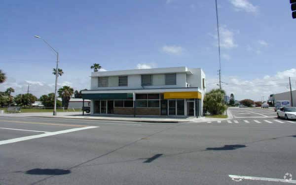
Property Record
15327 Gulf Blvd, Madeira Beach, FL 33708

Property Detail
15327 Gulf Blvd
Tampa-St. Petersburg-Clearwater, FL
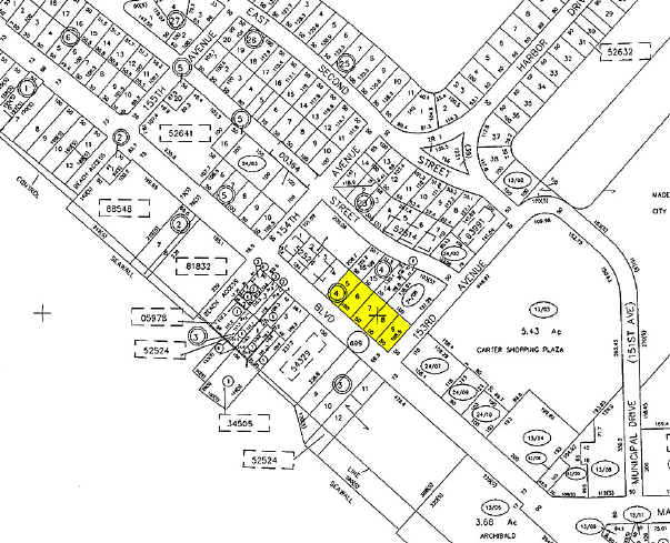
LONE PALM BEACH BLK 4, LOTS 5 THRU 9 LESS RD R/W
09-31-15-52524-004-0090
Pinellas
Storebuilding
Florida
AE The base floodplain where base flood elevations are provided. AE Zones are now used on new format FIRMs instead of A1-A30 Zones.
5-9
2024
0.61 AC
2025
South Pinellas
027801
Tampa/St Petersburg
6,667 SF
NEARBY LISTINGS FOR SALE OR LEASE
DEMOGRAPHICS near 15327 Gulf Blvd
1 mile
3 mile
5 mile
2025 Total Population
5,852
40,038
130,388
2030 Population
6,289
41,243
132,479
Pop Growth 2025-2030
+ 7.47%
+ 3.01%
+ 1.60%
Average Age
59
53
50
2025 Total Households
3,298
20,345
61,544
HH Growth 2025-2030
+ 7.43%
+ 3.14%
+ 1.79%
Median Household Inc
$86,997
$84,058
$79,149
Avg Household Size
1.80
1.90
2.10
2025 Avg HH Vehicles
1.00
2.00
2.00
Median Home Value
$704,215
$491,479
$423,426
Median Year Built
1974
1974
1973
Nearby Places
Map Layers
Map Styles
 Street
 Aerial
Layers
 Traffic
 Biking
Places
Listings with unknown addresses are not visible on the map
- Restaurants
- Banks
- Shops
- Fitness
- Groceries
PUBLIC TRANSPORTATION
AIRPORT
St Pete-Clearwater International
Drive
Walk
Distance
St Pete-Clearwater International
33 min
15.4 mi
Tampa International
Drive
Walk
Distance
Tampa International
43 min
26.2 mi
Freight Ports
Port Manatee
Drive
Walk
Distance
Port Manatee
51 min
33.4 mi
Nearby Properties
Address
Land Use
TOTAL SIZE
Lot Size
Zoning
Address
Land Use
TOTAL SIZE
Lot Size
Zoning
2,167,184 SF
297.75 AC
PSP
Address
Land Use
TOTAL SIZE
Lot Size
Zoning
372,952 SF
31.56 AC
Address
Land Use
TOTAL SIZE
Lot Size
Zoning
453,486 SF
15.73 AC
Address
Land Use
TOTAL SIZE
Lot Size
Zoning
328,466 SF
18.81 AC
Address
Land Use
TOTAL SIZE
Lot Size
Zoning
101,642 SF
1.43 AC
Address
Land Use
TOTAL SIZE
Lot Size
Zoning
5,647 SF
187.56 AC
AE
Address
Land Use
TOTAL SIZE
Lot Size
Zoning
29,644 SF
19.13 AC
Address
Land Use
TOTAL SIZE
Lot Size
Zoning
145,619 SF
1.68 AC
Address
Land Use
TOTAL SIZE
Lot Size
Zoning
160,086 SF
1.18 AC
Address
Land Use
TOTAL SIZE
Lot Size
Zoning
204,891 SF
18.20 AC
Address
Land Use
TOTAL SIZE
Lot Size
Zoning
236,240 SF
12.38 AC
RPD15
Address
Land Use
TOTAL SIZE
Lot Size
Zoning
222,888 SF
11.83 AC
RPD15
Address
Land Use
TOTAL SIZE
Lot Size
Zoning
385,858 SF
8.83 AC
Address
Land Use
TOTAL SIZE
Lot Size
Zoning
4,704 SF
3.36 AC
Address
Land Use
TOTAL SIZE
Lot Size
Zoning
176,209 SF
27.52 AC
Address
Land Use
TOTAL SIZE
Lot Size
Zoning
440 SF
3.47 AC
Address
Land Use
TOTAL SIZE
Lot Size
Zoning
151,421 SF
1.86 AC
Address
Land Use
TOTAL SIZE
Lot Size
Zoning
84,008 SF
1.49 AC
Address
Land Use
TOTAL SIZE
Lot Size
Zoning
160,616 SF
11.88 AC
Address
Land Use
TOTAL SIZE
Lot Size
Zoning
151,149 SF
8.84 AC
RM15
Address
Land Use
TOTAL SIZE
Lot Size
Zoning
6,531 SF
357.94 AC
PC
Address
Land Use
TOTAL SIZE
Lot Size
Zoning
147,755 SF
6.86 AC
Address
Land Use
TOTAL SIZE
Lot Size
Zoning
Address
Land Use
TOTAL SIZE
Lot Size
Zoning
132,714 SF
14.83 AC
UZ
Address
Land Use
TOTAL SIZE
Lot Size
Zoning
5,590 SF
6.38 AC
Address
Land Use
TOTAL SIZE
Lot Size
Zoning
139,181 SF
22.21 AC
R2
Address
Land Use
TOTAL SIZE
Lot Size
Zoning
57,532 SF
6.96 AC
Address
Land Use
TOTAL SIZE
Lot Size
Zoning
62,578 SF
5.45 AC
Address
Land Use
TOTAL SIZE
Lot Size
Zoning
235,268 SF
3.01 AC
Address
Land Use
TOTAL SIZE
Lot Size
Zoning
133,610 SF
12.84 AC
The World's #1 Commercial Real Estate Marketplace
Connect with us
© 2026 CoStar Group
The information above has been obtained from sources believed reliable. While we do not doubt its accuracy we have not verified it and make no guarantee, warranty or representation about it. It is your responsibility to independently confirm its accuracy and completeness. Any projections, opinions, assumptions, or estimates used are for example only and do not represent the current or future performance of the property. The value of this transaction to you depends on tax and other factors which should be evaluated by your tax, financial, and legal advisors. You and your advisors should conduct a careful, independent investigation of the property to determine to your satisfaction the suitability of the property for your needs.